

- Usage in publication:
-
- Black Mountain basalt flow
- Modifications:
-
- Original reference
- Dominant lithology:
-
- Basalt
- AAPG geologic province:
-
- Mojave basin
- San Joaquin basin
Summary:
Pg. 121-142. Black Mountain basalt flow. Olivine basalt, both vesicular and compact. Thickness more than 100 feet. Of post-Miocene Tertiary age, and younger than Rosamond series.
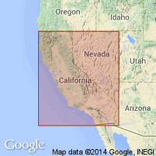
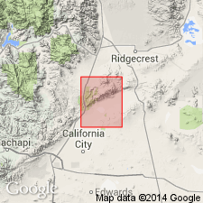
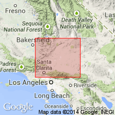
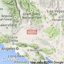
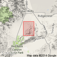
Local origin in Black Mountain, western El Paso Range, along northern boundary of Mojave Desert, eastern Kern Co., southern CA.
Source: US geologic names lexicon (USGS Bull. 896, p. 204); GNU records (USGS DDS-6; Menlo GNULEX).
- Usage in publication:
-
- Black Mountain basalt*
- Modifications:
-
- Revised
- Areal extent
- AAPG geologic province:
-
- Mojave basin
Summary:
Pg. 58-61. Black Mountain basalt. [Mapped (pl. 1, geol. map) in a few small isolated areas in the Summit Range, central northern part of Randsburg 15-min quadrangle, Kern and San Bernardino Cos., southern CA.] Consists of both intrusives and extrusives. Rocks may be classified as augite-hornblende basalts due to their dark color, dense groundmass, stony appearance, and are practically always highly vesicular, even in the intrusive facies. Intrudes Rosamond series and Red Mountain andesites. Age is probably very late Pliocene or early Pleistocene, based on stratigraphic relations and freshness of basalts. Origin of name stated.
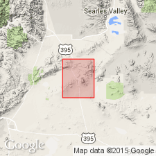
Named [by Baker, 1912] from widespread basalt flows on Black Mountain, 7 mi. west of El Paso Peaks in El Paso Mountains, where they overlie Tertiary sediments [approx. Lat. 35 deg. 28 min. 18 sec. N., Long. 117 deg. 50 min. 52 sec. W.], Satldale 15-min quadrangle, Kern Co., southern CA.
Source: Publication; US geologic names lexicons (USGS Bull. 896, p. 204; USGS Bull. 1200, p. 369); GNU records (USGS DDS-6; Menlo GNULEX).
- Usage in publication:
-
- Black Mountain basalt
- Modifications:
-
- Mapped
- Dominant lithology:
-
- Basalt
- AAPG geologic province:
-
- San Joaquin basin
Summary:
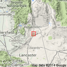
Pg. 30, pls. 1-3. Black Mountain basalt. Described in Saltdale quadrangle, [El Paso Mountains, Kern County, southern California], as a black to gray-black, fine-grained, diabase-textured, vesicular basalt flow, 50 to 150 feet thick; no superjacent strata. Younger than Ricardo formation and older than oldest terrace deposits in area. Age is probably Pleistocene.
Source: Publication; US geologic names lexicon (USGS Bull. 1200, p. 369).
- Usage in publication:
-
- Black Mountain Basalt*
- Modifications:
-
- Adopted
- Areal extent
- Age modified
- AAPG geologic province:
-
- Mojave basin
Summary:
Black Mountain Basalt of El Paso Mountains of Baker (1912) and as mapped by Dibblee (1952) is adopted. Also exposed on Black Mountain southwest of Opal Mountain and east of Opal Mountain. Overlies beveled surface of Barstow and Pickhandle Formations; laps eastward onto Mesozoic quartz monzonite and Lane Mountain Andesite (new). Is presumably of Pleistocene age based on unconformable relationship on formations as young as Pliocene, lensing out into gravel of older alluvium and preservation of top surface of lava flow.
Source: GNU records (USGS DDS-6; Menlo GNULEX).
- Usage in publication:
-
- Black Mountain Basalt*
- Modifications:
-
- Age modified
- Geochronologic dating
- Paleomagnetics
- AAPG geologic province:
-
- Mojave basin
Summary:
Age is Pliocene based on radiometric age of 2.55 +/-0.58 Ma from oldest flow on east flank of Black Mountain southwest of Opal Mountain. Reversed geomagnetic polarity in rocks suggest time of cooling was about 2.9 Ma (Mankinen and Dalrymple, 1979).
Source: GNU records (USGS DDS-6; Menlo GNULEX).
- Usage in publication:
-
- Black Mountain Basalt*
- Modifications:
-
- Areal extent
- Age modified
- Geochronologic dating
- AAPG geologic province:
-
- Mojave basin
Summary:
Unit geographically restricted to Black Mountain Basalt of Baker (1912) [El Paso Mountains]. Age is early and middle Miocene based on K-Ar determinations ranging from 17.9 +/-1.6 Ma (M.F. Diggles, unpub. data, 1982) near its base to 15.1 +/-0.5 Ma (J.L. Morton, unpub. data, 1979) near its top.
Source: GNU records (USGS DDS-6; Menlo GNULEX).
- Usage in publication:
-
- Black Mountain Basalt
- Modifications:
-
- Revised
- AAPG geologic province:
-
- Mojave basin
Summary:
Black Mountain Basalt is considered upper part [!] of Cudahy Camp Formation (new) of Ricardo Group. Occurs in Black Hills and Black Mountain of El Paso basin. Age is early and early middle Miocene based on K-Ar ages of 17.1 +/-0.5 Ma and 15.1 +/-0.5 Ma (Cox, 1982, PhD thesis).
Source: GNU records (USGS DDS-6; Menlo GNULEX).
For more information, please contact Nancy Stamm, Geologic Names Committee Secretary.
Asterisk (*) indicates published by U.S. Geological Survey authors.
"No current usage" (†) implies that a name has been abandoned or has fallen into disuse. Former usage and, if known, replacement name given in parentheses ( ).
Slash (/) indicates name conflicts with nomenclatural guidelines (CSN, 1933; ACSN, 1961, 1970; NACSN, 1983, 2005, 2021). May be explained within brackets ([ ]).