

- Usage in publication:
-
- Big Hole basalt*
- Modifications:
-
- Original reference
- Dominant lithology:
-
- Basalt
- AAPG geologic province:
-
- Snake River basin
Summary:
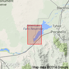
Pg. G25-G26, pl. 1. Big Hole basalt. Includes flows from different eruptive centers. Characteristically dense, blue gray to blue black; commonly contains a few megascopic olivine crystals. Contact with underlying sediments (Raft formation) in water well about 7 miles north of American Falls is at altitude of about 4,320 feet; lower contact about 5.5 miles west of American Falls is about 4,350 feet. Basalt at latter well is 150 feet thick, but thinner to east ranging from 56 to about 20 feet thick beneath Aberdeen terrace. Overlain by loess, sand dunes, American Falls lake beds, and terrace deposits. Stearns and others (1938, USGS Water-Supply Paper 774) thought this basalt was intercalated with American Falls lake beds; herein believed that underlying beds are Raft formation. Age is middle or late Pleistocene.
Type locality: Big Hole, a basalt-rimmed inlet on west side of the American Falls Reservoir, about 3 mi east of Aberdeen, [in T. 5 S., R. 32 E.], American Falls quadrangle, Bingham Co., southeastern ID. Crops out over most of northwest quarter of American Falls quadrangle, [in Bingham and Power Cos.].
[GNC remark (ca. 1967, US geologic names lexicon, USGS Bull. 1350, p. 65): The USGS currently classifies the Big Hole Basalt as a formation in the Snake River Group on the basis of a study now in progress.]
Source: US geologic names lexicon (USGS Bull. 1350, p. 65-66).
- Usage in publication:
-
- Big Hole Basalt*
- Modifications:
-
- Mapped
- AAPG geologic province:
-
- Snake River basin
Summary:
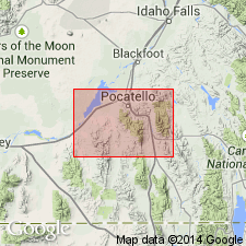
Big Hole Basalt. Basalt flows north of the Snake River above the Raft Formation. Thickness <150 feet (46 m). Recognized in Bingham and Power Counties, southeastern Idaho. Age is considered late Pleistocene. (Follows Carr and Trimble, 1963.)
Source: Publication.
For more information, please contact Nancy Stamm, Geologic Names Committee Secretary.
Asterisk (*) indicates published by U.S. Geological Survey authors.
"No current usage" (†) implies that a name has been abandoned or has fallen into disuse. Former usage and, if known, replacement name given in parentheses ( ).
Slash (/) indicates name conflicts with nomenclatural guidelines (CSN, 1933; ACSN, 1961, 1970; NACSN, 1983, 2005, 2021). May be explained within brackets ([ ]).