

- Usage in publication:
-
- Bemis moraine
- Modifications:
-
- Original reference
- AAPG geologic province:
-
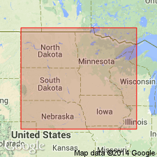
- Sioux uplift
Summary:
Pg. 102-103, and map. Name introduced for outermost moraine of Wisconsin drift in South Dakota, southern Minnesota, and northern Iowa, which was previously mapped as part of the Altamont moraine, but which is now known to be older than the moraine at Altamont, South Dakota, the type locality of Altamont moraine. Is of late Wisconsin age according to W.C. Alden.
Named for occurrence at Bemis, Deuel Co., South Dakota.
Source: US geologic names lexicon (USGS Bull. 896, p. 158).
- Usage in publication:
-
- Bemis moraine
- Modifications:
-
- Areal extent
- AAPG geologic province:
-
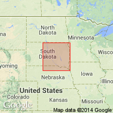
- Sioux uplift
Summary:
Pg. 100, 105, 107. Bemis moraine. Is the most continuous, single, end moraine in the Cary drift sheet, marking the drift border of the Des Moines lobe along the eastern flank of the Coteau des Prairies, in Deuel, Codington, Grant, and Roberts Counties, South Dakota. Because of its position contouring the flank of the Coteau des Prairies, against which the glacier pressed during a long period, this moraine is unusually high and narrow. It ranges in width from 1 to 4 miles, and in height from 30 to 60 feet. Its local relief (the differences in height between knolls and adjacent depressions) ranges from 15 to 30 feet. Good examples of narrow outwash bodies, or melt-water stream channels without outwash, usually leading to some transverse, premoraine valley, are seen along along the distal toe of the Bemis moraine throughout most of its course across Deuel County. West of Lake Hendricks and south of Oak Lake in northeastern Brookings County, the Bemis moraine lies along the northeast-facing flank of the Coteau des Prairies. In this sector a series of dry stream channels contour the slope at successively lower levels. Evidently they were cut by melt-water streams flowing along the margin of the Cary ice at successive positions of retreat. Within this group, minor channels in secs. 29 and 30, T. 112 N., R. 47 W., are discontinuous. In places they end abruptly, hanging above the regional slope. At these places they must have been flowing upon the thin margin of the glacier itself. Such channels were described in detail by Kendall, 1902 (Geol. Soc. London Quart. Jour., v. 58, p. 471-571), who termed them "in-and-out" channels.
Named the Bemis moraine by Leverett [1922, GSA Bull., v. 33, p. 102-103]; not 1932, USGS Prof. Paper 161, p. 57, as stated by author.
Source: Publication.
For more information, please contact Nancy Stamm, Geologic Names Committee Secretary.
Asterisk (*) indicates published by U.S. Geological Survey authors.
"No current usage" (†) implies that a name has been abandoned or has fallen into disuse. Former usage and, if known, replacement name given in parentheses ( ).
Slash (/) indicates name conflicts with nomenclatural guidelines (CSN, 1933; ACSN, 1961, 1970; NACSN, 1983, 2005, 2021). May be explained within brackets ([ ]).