

- Usage in publication:
-
- Begg formation
- Modifications:
-
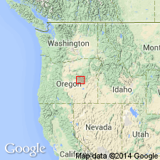
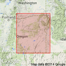
- Areal extent
- AAPG geologic province:
-
- Snake River basin
Summary:
Upper Triassic sequence includes Begg, Brisbois, and Rail Cabin formations. Thickness of sequence, which is overlain by Lower Jurassic Graylock formation (new), is nearly 15,000 feet.
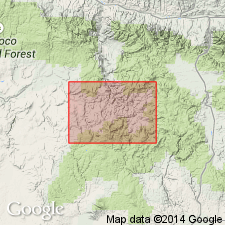
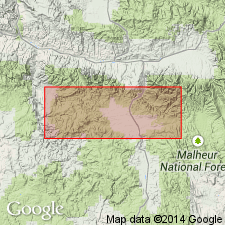
Type locality and derivation of name not stated by author. Report discusses Izee area, Grant Co., central OR.
Source: US geologic names lexicon (USGS Bull. 1200, p. 278).
- Usage in publication:
-
- Begg Formation
- Modifications:
-
- Original reference
- Dominant lithology:
-
- Sandstone
- Conglomerate
- Breccia
- AAPG geologic province:
-
- Snake River basin
- Usage in publication:
-
- Begg Formation
- Modifications:
-
- Overview
Summary:
Pg. 5. Begg Formation. Defined by Dickinson and Vigrass (1965), who designated type locality on nose and southeast limb of Little Bear anticline in northwestern part of Suplee-lzee district, in secs. 7, 8, 17, 18, and 20, T. 17 S., R. 26 E., and sec. 24, T. 17 S., R. 25 E., [Grant County], northeastern Oregon. The unit is fairly widespread in western and north-central part of Suplee-Izee district of central Oregon. It is equivalent to lower part of the Vester Formation located in Aldrich Mountains to the north. Consists of a maximum of 7,500 feet of resistant sandstone, conglomerate, and sedimentary breccia interbedded with less resistant mudstone and slltstone. Soft, carbonaceous, poorly sorted, noncalcareous, dark-gray to dark-green, fine-grained sandstone, siltstone and mudstone compose 50 to 70 percent of the unit. Cross-bedded, locally graded subfeldspathic lithic arenites, chert sandstones, and chert pebble conglomerates make up 25 percent of unit. Marine tuffs, which become increasingly finer grained upsection, make up 10 percent of unit. Thin flows of pyroxene keratophyre, minor polymictic conglomerates of chert, greenstone, and limestone, and sporadic lenses of limestone crop ouf locally. Rests unconformably on Paleozoic strata and grades upsection into Brisbois Formation. A poorly substantiated Karnian ([Late] Triassic) age is assigned to the unit. Is older than Karnian Brisbois Formation which overlies it, however, and the lower part of the unit may extend downsection into Middle Triassic.
See also Dickinson, W.R., and Vigrass, L.W., 1965, "Geology of the Suplee-Izee area, Cook, Grant, and Harney Counties, Oregon," Oregon Dept. Geol. and Min. Ind. Bull., no. 58, 109 p., geol. map (scale 1:42,000).
Source: Publication.
- Usage in publication:
-
- Begg Member*
- Modifications:
-
- Revised
- Adopted
- AAPG geologic province:
-
- Blue Mountains province
Summary:
Begg Member of Vester Formation. Begg Formation of Dickinson and Vigrass (1965) adopted by the USGS as lower of two members of Vester Formation. Present in northeastern Oregon. Unconformably overlies Paleozoic rocks; conformably underlies Brisbois Member (also newly adopted) of Vester. Age is Late Triassic (Carnian).
Source: Changes in stratigraphic nomenclature, 1977 (USGS Bull. 1457-A, p. A9).
For more information, please contact Nancy Stamm, Geologic Names Committee Secretary.
Asterisk (*) indicates published by U.S. Geological Survey authors.
"No current usage" (†) implies that a name has been abandoned or has fallen into disuse. Former usage and, if known, replacement name given in parentheses ( ).
Slash (/) indicates name conflicts with nomenclatural guidelines (CSN, 1933; ACSN, 1961, 1970; NACSN, 1983, 2005, 2021). May be explained within brackets ([ ]).