

- Usage in publication:
-
- Beaverdam formation
- Modifications:
-
- Original reference
- Dominant lithology:
-
- Shale
- Ash
- Conglomerate
- Sandstone
- AAPG geologic province:
-
- Great Basin province
Summary:
Pg. 6 (table 1), 9-10, 13, 15, 28, 75, 76 (table 2). Beaverdam formation in Idavada Volcanics. Since the Payette is not represented in Goose Creek basin, Idaho, name Beaverdam formation is proposed to supplant it for lowest part of Idavada volcanics. Composed chiefly of slabby, well-bedded, light-green and yellowish-gray, tuffaceous (rhyolitic) shale that makes up about half of formation; includes interbeds of friable, light-gray to white pumiceous ash, usually waterlaid; also includes conglomerate and sandstone beds which are up to a few tens of feet thick. Only about 200 feet of upper part of formation crops out in valley of Trapper Creek; 900 feet exposed in drainage of Beaverdam Creek. Underlies Jenny Creek formation; overlies Jarbidge rhyolite, or where Jarbidge absent, lies unconformably on Paleozoic rocks. Trapper Creek flora (middle Miocene) collected from ashy shale in upper 30 feet of formation. Age is considered middle Miocene (Hemingfordian to Barstovian NALMA; most probably early Barstovian).
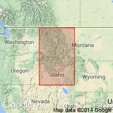
Named from exposures in upper drainage of Beaverdam Creek, just north of UT line, Cassia Co., southernmost ID.
Source: US geologic names lexicon (USGS Bull. 1350, p. 53); GNU records (USGS DDS-6; Denver GNULEX).
- Usage in publication:
-
- Beaverdam Formation*
- Modifications:
-
- Overview
- AAPG geologic province:
-
- Great Basin province
Summary:
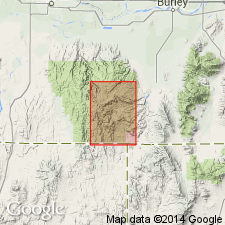
Usage follows Axelrod (1964). Term Idavada Volcanics not used. Mapped in the central part of the quad from approximately sec 27, T14S, R20E south to southern border of map (Cassia Co, ID) with NV [unit obviously continues south into Elko Co, NV] in the Great Basin province. Consists of greenish-gray tuffaceous shale, white volcanic ash, and several beds of carbonaceous shale, sandstone, and conglomerate. Thickness is about 270 m. Assigned to late Miocene. Is older than the Miocene tuff of Ibex Peak. Is younger than a conglomerate of pre-late Miocene age.
Source: GNU records (USGS DDS-6; Denver GNULEX).
For more information, please contact Nancy Stamm, Geologic Names Committee Secretary.
Asterisk (*) indicates published by U.S. Geological Survey authors.
"No current usage" (†) implies that a name has been abandoned or has fallen into disuse. Former usage and, if known, replacement name given in parentheses ( ).
Slash (/) indicates name conflicts with nomenclatural guidelines (CSN, 1933; ACSN, 1961, 1970; NACSN, 1983, 2005, 2021). May be explained within brackets ([ ]).