

- Usage in publication:
-
- Bear Valley Formation
- Modifications:
-
- Original reference
- Dominant lithology:
-
- Volcanic arenite
- AAPG geologic province:
-
- Great Basin province
- Paradox basin
Summary:
Pg. 21; Dissert. Abs., v. 26, no. 12, pt. 1, p. 7256, 1966. Bear Valley Formation. In northern Markagunt Plateau, southwestern Utah, consists of up to 1,000 feet of wind-deposited volcanic arenite (sandstone) with minor interbeds of tuff, lava flows, and mud flow-breccias. Unit blanketed most of the plateau. Deposition of Bear Valley Formation was ended by inundation of at least 2,000 feet of volcanic flows and mud flow-breccias of Cottonwood Canyon Formation (new). Age is Miocene(?).
Type locality and origin of name not stated.
Source: US geologic names lexicon (USGS Bull. 1350, p. 52).
- Usage in publication:
-
- Bear Valley Formation
- Modifications:
-
- Principal reference
- Geochronologic dating
- Dominant lithology:
-
- Sandstone
- Conglomerate
- Breccia
- AAPG geologic province:
-
- Paradox basin
Summary:
Bear Valley Formation. Subdivided into 5 units (descending): (1) cross-bedded, fine- to medium-grained sandstone, 352 feet; (2) sandy muddy pebble conglomerate, 63 feet; (3) cross-bedded, fine- to medium-grained sandstone with lenses of volcanic breccia mudflows in upper part, 389+ feet; (4) fine- to medium-grained sandstone interbedded with conglomeratic sandy mudstone, 123 feet; and (5) a basal zeolitic supermature volcanic arenite, 20 feet. Total thickness at type 1,059 feet. Includes strata previously assigned to Brian Head Formation by Gregory (1945, 1950). Lies above Roger Park Breccia of Callahan (1939). No fossils. Age is considered late Oligocene to Miocene, based on isotopic ages of 24.0 +/-0.3 Ma and 23.9 +/-0.4 Ma from middle part (Robert Fleck, 1970, written commun.) and stratigraphic relations.
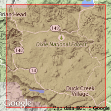
Type section: north of UT Highway 20 about 1.5 mi west of its junction with U.S. Highway 89, from SE/4 NW/4 sec. 5, T. 33 S., R. 5 W. to NE/4 SE/4 sec. 32, T. 32 S., R. 5 W., northern Markagunt Plateau, Garfield Co., UT. Named from Bear Valley. Recognized in northern Markagunt Plateau, Red Hills, and Black Mountains.
Source: Publication.
- Usage in publication:
-
- Bear Valley Formation*
- Modifications:
-
- Age modified
- Dominant lithology:
-
- Sandstone
- Lava
- Tuff
- Breccia
- AAPG geologic province:
-
- Great Basin province
Summary:
Pg. B10-B11 (fig. 2), B15; see also Anderson and Rowley, 1975, GSA Spec. Paper 160, p. 1-51. Bear Valley Formation of Anderson (1966, 1971) is adopted by the USGS. Is primarily a green, yellow, or gray sandstone (volcanic arenite) largely of eolian origin; locally contains thin beds of volcanic mudflow breccia, conglomerate, lava flow, and air-fall and ash-flow tuff. Maximum thickness 330 m. In southwestern Black Mountains, underlies Condor Canyon Formation and overlies Leach Canyon Formation, both of Quichapa Group; [Bear Valley is not part of Quichapa Group]. In Markagunt Plateau, underlies Mount Dutton Formation (alluvial facies) and overlies Buckskin Breccia (new) or Isom Formation; is intercalated with Narrows Tuff Member of Leach Canyon. Age is considered Miocene, based on K-Ar ages of about 24 Ma by Fleck and others (1975, GSA Spec. Paper 160, p. 53-62).
Notable exposures in southwestern Black Mountains, northern Red Hills, and northern Markagunt Plateau, southwestern Utah.
Source: Publication; Changes in stratigraphic nomenclature, 1976 (USGS Bull. 1435-A, p. A6, Condor Canyon entry p. A23-A24).
- Usage in publication:
-
- Bear Valley Formation*
- Modifications:
-
- Geochronologic dating
- Age modified
- AAPG geologic province:
-
- Wasatch uplift
Summary:
Bear Valley Formation. Generally soft, light-gray and locally yellow and green, moderately to well sorted, fine- to medium-grained, "salt-and-pepper" tuffaceous sandstone of eolian and fluvial origin and minor, resistant, gray, and light-pink volcanic mudflow breccia, white airfall tuff, and red and brown, highly welded ash-flow tuff. Thickness up to 300 m. Interbedded with Oligocene Kingston Canyon Tuff Member of Mount Dutton Formation. Age is Oligocene, based on K-Ar ages of about 25 Ma determined from two volcanic beds within formation (citing Fleck and others, GSA Spec. Paper 160, p. 53-62; age corrected for new decay constants of Steiger and Jager, 1977).
Notable exposures in southern part of map, Garfield Co., southwestern UT. [See also Anderson and Rowley, 1987, geol. map of Panguitch NW quadrangle, Iron and Garfield Cos., UT, Utah Geol. Min. Survey Map, no. 103, scale 1:24,000, incl. pamphlet, 8 p.]
Source: Publication.
For more information, please contact Nancy Stamm, Geologic Names Committee Secretary.
Asterisk (*) indicates published by U.S. Geological Survey authors.
"No current usage" (†) implies that a name has been abandoned or has fallen into disuse. Former usage and, if known, replacement name given in parentheses ( ).
Slash (/) indicates name conflicts with nomenclatural guidelines (CSN, 1933; ACSN, 1961, 1970; NACSN, 1983, 2005, 2021). May be explained within brackets ([ ]).