

- Usage in publication:
-
- Baxter shale*
- Modifications:
-
- Original reference
- Dominant lithology:
-
- Shale
- Sandstone
- AAPG geologic province:
-
- Green River basin
Summary:
Baxter shale. Black and drab shales, very soft and friable; shaly sandstones and arenaceous shale, in places highly gypsiferous. Greater part of formation is shale. Thickness undetermined; 1,000 feet exposed in Baxter basin, but base not seen. Underlies Blair formation. Contains fossils of Montana age (Late Cretaceous).
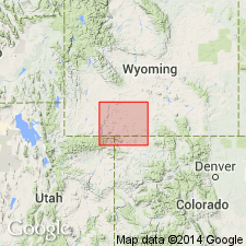
Named from exposures in vicinity of Baxter, [a station on the Union Pacific RR, in T. 19 N., R. 104 W.], Sweetwater Co., southwestern WY.
Source: US geologic names lexicon (USGS Bull. 896, p. 127).
- Usage in publication:
-
- Baxter shale*
- Modifications:
-
- Revised
- AAPG geologic province:
-
- Green River basin
Summary:
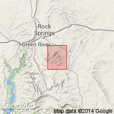
Pg. 16, 19, map. Baxter shale. Between Frontier and Blair formations in Baxter basin, Sweetwater County, southwestern Wyoming, is 3,350 to 3,600 feet of homogeneous gray and drab shale, in part of Colorado and in part of Montana age. Only upper part of this shale is exposed. Schultz gave name Baxter shale to this part, but in present report the name is extended to include the whole body. It includes numerous zones of calcareous concretions and soft thin-bedded sandstone. Thickness in Rock Springs uplift 3,350 to 3,600 feet. A sandstone 850+/- feet below top of formation is called "marker bed" and is believed to mark base of Montana part of Baxter shale. [Age is Late Cretaceous.]
Source: US geologic names lexicon (USGS Bull. 896, p. 127).
For more information, please contact Nancy Stamm, Geologic Names Committee Secretary.
Asterisk (*) indicates published by U.S. Geological Survey authors.
"No current usage" (†) implies that a name has been abandoned or has fallen into disuse. Former usage and, if known, replacement name given in parentheses ( ).
Slash (/) indicates name conflicts with nomenclatural guidelines (CSN, 1933; ACSN, 1961, 1970; NACSN, 1983, 2005, 2021). May be explained within brackets ([ ]).