

- Usage in publication:
-
- Barker Dome tongue*
- Modifications:
-
- Original reference
- Dominant lithology:
-
- Sandstone
- AAPG geologic province:
-
- San Juan basin
Summary:
Sheet 1. Barker Dome tongue of Cliff House sandstone of Mesaverde group. Most extensive tongue of basal Cliff House sandstone in Menefee formation in Barker Dome-Fruitland area is here named Barker Dome tongue. Southwestern wedge-edge of this tongue trends N. 45 deg. W., as determined by exposures in Mancos Canyon and at Barker Dome. From this depositional edge, tongue extends approximately 2.5 miles northeastward before it coalesces with main body of Cliff House sandstone. Contacts are sharp. Age is Late Cretaceous.
Crops out on Barker Dome, southern Ute Dome, and in upper drainage of Barker Creek, northwestern NM; also in walls of Mancos Canyon, southwestern CO.
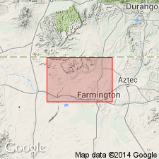
[Barker Dome in Purgatory Canyon and Red Horse Gulch 7.5-min quadrangles, San Juan Co., northwestern NM, and La Plata Co., southwestern CO.]
Source: US geologic names lexicon (USGS Bull. 1200, p. 215).
For more information, please contact Nancy Stamm, Geologic Names Committee Secretary.
Asterisk (*) indicates published by U.S. Geological Survey authors.
"No current usage" (†) implies that a name has been abandoned or has fallen into disuse. Former usage and, if known, replacement name given in parentheses ( ).
Slash (/) indicates name conflicts with nomenclatural guidelines (CSN, 1933; ACSN, 1961, 1970; NACSN, 1983, 2005, 2021). May be explained within brackets ([ ]).