

- Usage in publication:
-
- Banjo Point formation*
- Modifications:
-
- Named
- Biostratigraphic dating
- Dominant lithology:
-
- Sandstone
- Conglomerate
- Shale
- Tuff
- AAPG geologic province:
-
- Aleutian Islands province
Summary:
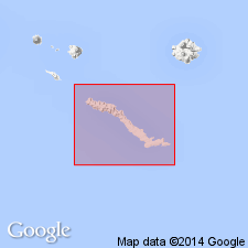
Partial type section designated on north coast at Banjo Point, Amchitka Island, Aleutian Islands, southwestern AK. Occupies entire width of island westward from Makarius Bay about 5 mi west of Banjo Point, several sq mi at Saint Makarius Point, and north coast west of Kirilof Point. Consists of bedded marine sandstone, conglomerate, tuffaceous shale, and some lapilli tuff. Thickness could be as little as 400 ft since top is erosion surface. Is 138 ft thick at type section. Unconformably overlies Amchitka formation (new). West of Banjo Point is in fault contact with Chitka Point formation (new). On basis of meager fauna, age is considered Oligocene to Miocene.
Source: GNU records (USGS DDS-6; Menlo GNULEX).
- Usage in publication:
-
- Banjo Point Formation*
- Modifications:
-
- Areal extent
- Age modified
- Biostratigraphic dating
- AAPG geologic province:
-
- Aleutian Islands province
- Alaska Southwestern region
Summary:
Basaltic breccias mapped as Chitka Point Formation, now included in Banjo Point Formation, extend southeastward along Pacific coast of Amchitka Island. Banjo Point Formation is late Eocene or Oligocene age on basis of mollusks and numerous microfossils from several localities; table included in report. K-Ar ages of dikes intruding Banjo Point Formation range from 10.2 +/-1.1 to 8.9 +/-0.6 Ma.
Source: GNU records (USGS DDS-6; Menlo GNULEX).
For more information, please contact Nancy Stamm, Geologic Names Committee Secretary.
Asterisk (*) indicates published by U.S. Geological Survey authors.
"No current usage" (†) implies that a name has been abandoned or has fallen into disuse. Former usage and, if known, replacement name given in parentheses ( ).
Slash (/) indicates name conflicts with nomenclatural guidelines (CSN, 1933; ACSN, 1961, 1970; NACSN, 1983, 2005, 2021). May be explained within brackets ([ ]).