

- Usage in publication:
-
- Balaklala rhyolite*
- Modifications:
-
- Named
- Dominant lithology:
-
- Rhyolite
- Tuff
- AAPG geologic province:
-
- Klamath Mountains province
Summary:
Named for exposures in hills about Balaklala mine. [No type locality designated.] Is succession of irregular lava flows and tuffs which have been so compressed and folded as to render very obscure original layered arrangement of mass. Thickness is about 500 ft. Underlies Kennett limestone and shale. Overlies and penetrates Copley meta-andesite. Is Jurassic(?) age.
Source: GNU records (USGS DDS-6; Menlo GNULEX).
- Usage in publication:
-
- Balaklala rhyolite†
- Modifications:
-
- Abandoned
- AAPG geologic province:
-
- Klamath Mountains province
Summary:
Abandoned because unit is intrusive alaskite porphyry based on: 1) dikes, sills, and other intrusive masses of it cut surrounding rocks, 2) at many places along contact with other rocks, alaskite porphyry is finer grained than elsewhere, 3) overlying or adjoining rocks are brecciated at many places along contact with alaskite porphyry and at most such points the shales are indurated and more or less metamorphosed. [No replacement name given.]
Source: GNU records (USGS DDS-6; Menlo GNULEX).
- Usage in publication:
-
- Balaklala rhyolite*
- Modifications:
-
- Reinstated
- Age modified
- AAPG geologic province:
-
- Klamath Mountains province
Summary:
Reinstated as formal stratigraphic unit because new evidence indicates formation is composed principally of extrusive rhyolite and pyroclastics and not intrusive alaskite porphyry as considered by Graton(1910a) who abandoned the name. Interpretation of the surface origin of much of the unit is based on its internal features and on evidence seen at contacts. Consists principally of silicic flows interlayered with coarse and fine silicic pyroclastics; about one-forth of rhyolite is pyroclastic Flows and pyroclastics are abnormally rich in soda and silica; they are light-colored and commonly porphyritic, with phenocrysts of quartz and plagioclase (1 to 7 mm). Fossil evidence gives Middle Devonian age.
Source: GNU records (USGS DDS-6; Menlo GNULEX).
- Usage in publication:
-
- Balaklala rhyolite*
- Modifications:
-
- Areal extent
- AAPG geologic province:
-
- Klamath Mountains province
Summary:
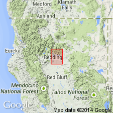
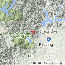
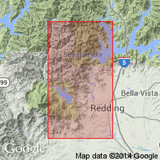
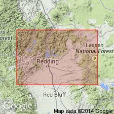
Crops out in belt 16 mi long and 8 mi wide from southern half of Whiskeytown quad to southwest quarter of Behemotosh quad. Consists of silicic flows, breccias, and tuffs having maximum thickness in excess of 1,000 m. Is divided into three informal units: lower nonporphyritic to slightly porphyritic unit containing large amounts of breccia and tuff (600 m thick in Mammoth mine area, thinning out in all directions); middle unit of medium-grained rhyolite with quartz phenocrysts of 1-4 mm with massive sulfide bodies in upper part (average thickness of 100 m, but up to 450 m); and upper unit with dark quartz phenocrysts in excess of 5 mm and thickness of about 100 m. Intrusive bodies typical of middle unit is recognized in many places in district. At least six eruptive centers for Balaklala Rhyolite are identified, three of them within 17x3 km area which constitutes limits of former mining district. Small dikes, sills, and plugs of Balaklala cut underlying Copley greenstone; in some areas flows interfinger with Copley greenstone. Conformably underlies Kennett formation.
Source: GNU records (USGS DDS-6; Menlo GNULEX).
- Usage in publication:
-
- Balaklala Rhyolite*
- Modifications:
-
- Geochronologic dating
- Age modified
- AAPG geologic province:
-
- Klamath Mountains province
Summary:
Balaklala Rhyolite. Age is refined from Middle Devonian to early Middle Devonian based on concordant K-Ar and U-Pb isotopic ages of ca. 400 Ma for Mule Mountain stock. Based on petrologic and geochemical studies of Mule Mountain stock and Balaklala Rhyolite, Barker and others (1979) suggest cogenetic origin of these units.
Source: Modified from GNU records (USGS DDS-6; Menlo GNULEX).
- Usage in publication:
-
- Balaklala Rhyolite*
- Modifications:
-
- Age modified
- AAPG geologic province:
-
- Klamath Mountains province
Summary:
Age revised from Middle Devonian to: Early Devonian based on presumed cogenetic origin with 400 Ma Mule Mountain stock (with U-Pb ages of 400 and 387 Ma; K-Ar ages of 392 +/-3 Ma).
Source: GNU records (USGS DDS-6; Menlo GNULEX).
- Usage in publication:
-
- Balaklala Rhyolite*
- Modifications:
-
- Age modified
- Geochronologic dating
- Biostratigraphic dating
- AAPG geologic province:
-
- Klamath Mountains province
Summary:
Age revised from Early Devonian to: Early(?) and Middle Devonian based on stratigraphic relations, fossils (Eifelian fish plate), and radiometric ages (400Ma; U-Pb).
Source: GNU records (USGS DDS-6; Menlo GNULEX).
For more information, please contact Nancy Stamm, Geologic Names Committee Secretary.
Asterisk (*) indicates published by U.S. Geological Survey authors.
"No current usage" (†) implies that a name has been abandoned or has fallen into disuse. Former usage and, if known, replacement name given in parentheses ( ).
Slash (/) indicates name conflicts with nomenclatural guidelines (CSN, 1933; ACSN, 1961, 1970; NACSN, 1983, 2005, 2021). May be explained within brackets ([ ]).