

- Usage in publication:
-
- Atkinson formation*
- Modifications:
-
- Original reference
- Dominant lithology:
-
- Sandstone
- Shale
- AAPG geologic province:
-
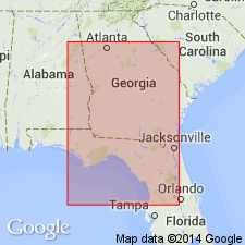
- South GA-North FL sedimentary province
Summary:
Atkinson Formation. Comprises subsurface deposits of early Upper Cretaceous sequence occurring between base of beds of Austin age and top of Lower Cretaceous. On basis of differences in lithology, formation is divided into three unnamed members. Recognized in subsurface of Georgia, Alabama, and Florida.
Named from Atkinson Co., south-central GA, where Sun Oil Company drilled Doster-Ladson No. 1 well (Lot 71, Land District 7).
Source: US geologic names lexicon (USGS Bull. 1200, p. 164).
- Usage in publication:
-
- Atkinson Formation
- Modifications:
-
- Areal extent
- AAPG geologic province:
-
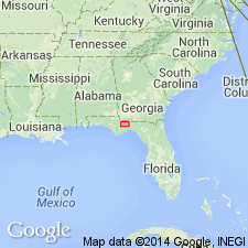
- South Georgia sedimentary province
Summary:
Applin and Applin (1944) referred rocks of the Atkinson Formation to the Tuscaloosa, before naming them Atkinson in 1947. Though divisible into lower, middle, and upper members in the western and central areas of the FL panhandle, only the upper and lower members can be identified in the eastern portion of the panhandle. In Gadsden Co., the lower member is a distinct, massive quartz sand interbedded with varicolored shales. The upper member is predominantly gray and lignitic shale with interbedded sand. The top of the upper member falls between -3,200 and -3,350 ft MSL. Unit underlies a series of unnamed, Upper Cretaceous siliciclastic and calcareous sediments.
Source: GNU records (USGS DDS-6; Reston GNULEX).
- Usage in publication:
-
- Atkinson Formation
- Modifications:
-
- Areal extent
- AAPG geologic province:
-
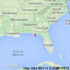
- South Georgia sedimentary province
Summary:
Late Cretaceous Atkinson Formation in Gulf Co., FL, is equivalent to the Tuscaloosa Formation of AL. Only the lower unnamed member is present in the study area and it ranges in thickness from 400 to 800 ft. It is composed of light-colored sands and interbedded calcareous and glauconitic sands and shales containing Foraminifera. Overlies thick sequence of Lower Cretaceous undifferentiated reddish and reddish-brown interbedded shales and sandstones. Underlies uppermost Cretaceous unnamed white, chalky limestones and interbedded gray to light green calcareous shales.
Source: GNU records (USGS DDS-6; Reston GNULEX).
For more information, please contact Nancy Stamm, Geologic Names Committee Secretary.
Asterisk (*) indicates published by U.S. Geological Survey authors.
"No current usage" (†) implies that a name has been abandoned or has fallen into disuse. Former usage and, if known, replacement name given in parentheses ( ).
Slash (/) indicates name conflicts with nomenclatural guidelines (CSN, 1933; ACSN, 1961, 1970; NACSN, 1983, 2005, 2021). May be explained within brackets ([ ]).