

- Usage in publication:
-
- Addy quartzite
- Modifications:
-
- Original reference
- Dominant lithology:
-
- Quartzite
- AAPG geologic province:
-
- Northern Cascade Range-Okanagan province
Summary:
Pg. 61, map. Addy quartzite. Chiefly massive, hard, crystalline, light-colored quartzite. Associated with it in subordinate amounts are belts of quartz-mica schist, highly metamorphosed banded slates, and well banded quartzites with much white mica developed. In vicinity of Addy the hard massive phase grades over into alternating interbedded quartzites and argillites in bands from a few inches to several feet thick. Thickness 8,000+/- feet. Overlies Deer Trail argillite (new) and underlies Chewelah argillite (new) and Old Dominion limestone (new); apparently conformable both above and below. Age is Paleozoic (Stevens series).
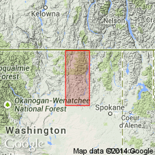
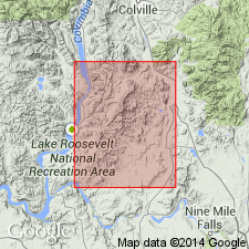
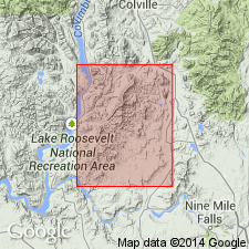
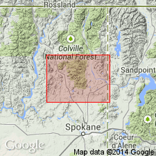
[Named from Addy, in sec. 13, T. 33 N., R. 39 E., Stevens Co., northeastern WA; no "type" designated by original author.] Constitutes Dunn Mountain and crest of Huckleberry Mountains; to east crosses Colville Valley between Chewelah and Addy, Stevens Co., northeastern WA. Is approximately 150 sq mi.
Source: US geologic names lexicon (USGS Bull. 896, p. 14); supplemental information from GNU records (USGS DDS-6; Menlo GNULEX).
- Usage in publication:
-
- Addy quartzite
- Modifications:
-
- Revised
- AAPG geologic province:
-
- Northern Cascade Range-Okanagan province
Summary:
Pg. 9, pls. 1, 2. Addy quartzite. Restricted to exclude underlying greenstone and conglomerate. These units, now named Huckleberry greenstone and Huckleberry conglomerate, were included in Addy by Weaver (1920). Thickness at least 3000 feet; may be as much as 5000 feet. Mapped in magnesite belt (north and south halves). In most areas, overlies greenstone, but in south, locally overlaps greenstone and overlies schistose conglomerate. Overlain by what are presumably extensions of Old Dominion limestone that contain fossils of brachiopod KUTURGINA CINGULATA (Billings) of Early Cambrian age; therefore tentatively assigned Early Cambrian age.
Source: US geologic names lexicon (USGS Bull. 1200, p. 19); GNU records (USGS DDS-6; Menlo GNULEX).
- Usage in publication:
-
- Addy quartzite
- Modifications:
-
- Biostratigraphic dating
- AAPG geologic province:
-
- Okanogan province
Summary:
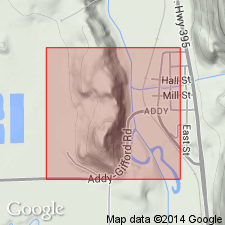
Olenellid trilobite fragments and brachiopods collected from Addy quartzite near Addy, in SW/4 sec. 13, T. 33 N. R. 39 E., Stevens Co., WA [later designated type locality (see entry under Campbell and Loofbourow, 1962)]. Presence of NEVADIA suggest lower portion of Early Cambrian age.
Source: GNU records (USGS DDS-6; Menlo GNULEX).
- Usage in publication:
-
- Addy quartzite*
- Modifications:
-
- Principal reference
- Adopted
- AAPG geologic province:
-
- Okanogan province
Summary:
Pg. F24-F25. Bennett's (1941) Addy quartzite is adopted by the USGS. Bennett restricted Addy quartzite of Weaver (1920) to exclude underlying greenstone and conglomerate [now unnamed members of Huckleberry formation]. Where exposed is thin-bedded, or, less commonly, massive ledge-forming quartzite, bluish-gray to white; distinctive phase has bedding planes emphasized by thin purple bands. Age is early Early Cambrian (citing Okulitch, 1951).
Type locality [designated]: near Addy, in SW/4 sec. 13, T. 33 N., R. 39 E., Stevens Co., WA (=fossil locality of Okulitch, 1951).
Source: Publication; GNU records (USGS DDS-6; Menlo GNULEX).
- Usage in publication:
-
- Addy Quartzite*
- Modifications:
-
- Age modified
- Biostratigraphic dating
- AAPG geologic province:
-
- Okanogan province
Summary:
Age of the Addy Quartzite [everywhere] is revised from Early Cambrian to: Late Proterozoic and Cambrian [following the usage of Lindsay and others, 1990] based on regional stratigraphic relations and fossils [trilobites, trace fossils] found well above the base (at least 500 m) of the unit.
Source: GNU records (USGS DDS-6; Menlo GNULEX).
For more information, please contact Nancy Stamm, Geologic Names Committee Secretary.
Asterisk (*) indicates published by U.S. Geological Survey authors.
"No current usage" (†) implies that a name has been abandoned or has fallen into disuse. Former usage and, if known, replacement name given in parentheses ( ).
Slash (/) indicates name conflicts with nomenclatural guidelines (CSN, 1933; ACSN, 1961, 1970; NACSN, 1983, 2005, 2021). May be explained within brackets ([ ]).