

- Usage in publication:
-
- Aberdeen sandstone member*
- Modifications:
-
- Original reference
- Adopted
- Dominant lithology:
-
- sandstone
- AAPG geologic province:
-
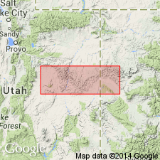
- Uinta basin
Summary:
Aberdeen sandstone member, basal member of Blackhawk formation of Mesaverde group. Massive, medium-grained buff sandstone, 60 to 200 feet thick, lying 160+/- feet above Star Point sandstone. Underlies Castlegate "A" coal of Blackhawk and overlies lower part of Spring Canyon coal group, but in places grades laterally into part of that coal group. In Wellington and Sunnyside 15-min quadrangles, interfingers with Mancos shale. Age is Late Cretaceous (on geologic map legend).
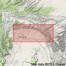
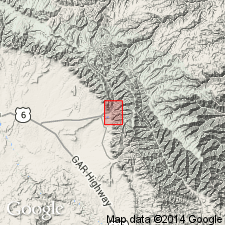
Exposed near Aberdeen Mine, northeast of Kenilworth, Book Cliffs, Castlegate 15-min quadrangle, west Carbon Co., central eastern UT.
[Aberdeen Mine, Lat. 39 deg. 42 min. 18 sec. N., Long. 110 deg. 47 min. 19 sec. W., Helper 7.5-min quadrangle, Carbon Co., central eastern UT.]
Source: US geologic names lexicon (USGS Bull. 896, p. 8); supplemental information from GNU records (USGS DDS-6; Menlo GNULEX).
- Usage in publication:
-
- Aberdeen member*
- Modifications:
-
- Revised
- Redescribed
- Dominant lithology:
-
- Sandstone
- Shale
- Coal
- AAPG geologic province:
-
- Uinta basin
Summary:
Pg. 183, 184, pl. 3. Aberdeen member of Blackhawk formation. Is one of six members of the Blackhawk formation. Redescribed from Aberdeen sandstone member [of Clark (1928)]. Stratigraphically extended; includes not only the massive sandstones [of Clark (1928)] near the Aberdeen Mine, but also includes overlying coal-bearing rocks and associated offshore bar deposits exposed in the Uinta basin, between Coal Creek Canyon and Storrs, Carbon County, Utah. Consists of basal white-capped sandstone with maximum thickness of 88 feet and an overlying series of shale, sandstone, and coal with a maximum thickness of about 100 feet at Kenilworth. The coal-bearing rocks consist of (ascending) gray to black shale, argillaceous, medium- to fine-grained sandstone, and 4 coal beds identified as (ascending) Aberdeen (or Castlegate "A"), Castlegate "B", Royal Blue, and Castlegate "C". Between Kenilworth and Coal Canyon, these coal beds are replaced by five bar sandstones, which grade east into Mancos. The second sandstone from base is the most persistent. The bar sandstones are white-capped on the lagoonal side; they contain dune, back-shore, and lower foreshore laminae. Overlies Spring Canyon member (new) of Blackhawk; underlies Kenilworth member (new) of Blackhawk. Age is Late Cretaceous. Report includes cross sections.
Source: US geologic names lexicon (USGS Bull. 1200, p. 8-9); supplemental information from GNU records (USGS DDS-6; Denver GNULEX).
- Usage in publication:
-
- Aberdeen Member*
- Modifications:
-
- Areal extent
- AAPG geologic province:
-
- Uinta basin
Summary:
Aberdeen Member, basal member of Blackhawk Formation of Mesaverde Group (Young's (1955) basal member of Blackhawk Formation, the Spring Canyon Member, is not present in the district). Outcrops extend from the Sunnyside area, Carbon County, Utah (Uinta basin), to east side of Whitmore Canyon; may extend into Horse Canyon, about 8 miles south of town of Sunnyside. Represented only by a thin, clayey, organic-rich, calcareous, slightly gypsiferous, thinly laminated sandstone composed of very fine-grained, well-rounded quartz and containing a few trace fossils. Is overlain and underlain by Mancos Shale. Age is Late Cretaceous. Report includes geologic map, cross sections, nomenclature chart.
Source: Modified from GNU records (USGS DDS-6; Denver GNULEX).
For more information, please contact Nancy Stamm, Geologic Names Committee Secretary.
Asterisk (*) indicates published by U.S. Geological Survey authors.
"No current usage" (†) implies that a name has been abandoned or has fallen into disuse. Former usage and, if known, replacement name given in parentheses ( ).
Slash (/) indicates name conflicts with nomenclatural guidelines (CSN, 1933; ACSN, 1961, 1970; NACSN, 1983, 2005, 2021). May be explained within brackets ([ ]).