

- Usage in publication:
-
- Camillus shale
- Modifications:
-
- Named
- Dominant lithology:
-
- Shale
- Gypsum
- Dolomite
- AAPG geologic province:
-
- Appalachian basin
Summary:
Named as part of the Salina beds. Consists of shale (gypsum and platten dolomites). Underlies Bertie waterlime; overlies Syracuse salt. Age is Silurian.
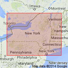
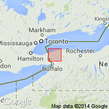
Named from exposures at Camillus, Onondaga Co., central NY.
Source: Modified from GNU records (USGS DDS-6; Reston GNULEX).
- Usage in publication:
-
- Camillus shale member*
- Modifications:
-
- Revised
- AAPG geologic province:
-
- Appalachian basin
Summary:
Rank reduced as Camillus shale member of Salina formation.
Source: GNU records (USGS DDS-6; Reston GNULEX).
- Usage in publication:
-
- Camillus shale
- Modifications:
-
- Revised
- Age modified
- AAPG geologic province:
-
- Appalachian basin
Summary:
Chart 3. Camillus shale of Salina group. Occurs above Syracuse salt and below Bertie waterline. Age is Late Silurian (Cayugan).
Source: US geologic names lexicon (USGS Bull. 1200, p. 592-593).
- Usage in publication:
-
- Camillus Shale
- Modifications:
-
- Areal extent
- AAPG geologic province:
-
- Appalachian basin
Summary:
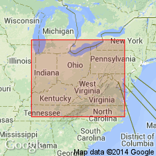
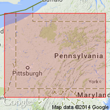
Shown in the subsurface in several wells in OH, PA, WV; this report extends the Camillus from NY into the subsurface of these States.
Source: GNU records (USGS DDS-6; Reston GNULEX).
For more information, please contact Nancy Stamm, Geologic Names Committee Secretary.
Asterisk (*) indicates published by U.S. Geological Survey authors.
"No current usage" (†) implies that a name has been abandoned or has fallen into disuse. Former usage and, if known, replacement name given in parentheses ( ).
Slash (/) indicates name conflicts with nomenclatural guidelines (CSN, 1933; ACSN, 1961, 1970; NACSN, 1983, 2005, 2021). May be explained within brackets ([ ]).