The National Geologic Map Database is migrating to a new infrastructure. We apologize for any service disruptions during this process.
|
|---|


- Usage in publication:
-
- Bass limestone*
- Modifications:
-
- Original reference
- Dominant lithology:
-
- Limestone
- Shale
- AAPG geologic province:
-
- Southern Rocky Mountain region
Summary:
Bass limestone of Unkar group of Grand Canyon series. White crystalline limestone alternating with beds of argillaceous and calcareous red shale containing sun cracks. Thickness 335 feet. Cut by a thick sill of intrusive diabase. Conformably underlies Hakatai shale and conformably overlies Hotauta conglomerate, all of which belong to Unkar group. Age is pre-Cambrian (Algonkian). Report includes geologic map.
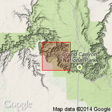
Named from Bass Canyon, south side of Colorado River, Grand Canyon, Shinumo quadrangle, Coconino Co., northern AZ, where typically exposed.
Measured section 304+ ft in Hotauta Canyon. Consists of (ascending) white cherty limestone; argillaceous and calcareous red shale and purple cherty to red crystalline limestone; white cherty limestone with some interbedded purple to red shale; and blue slate and white crystalline limestone.
Source: US geologic names lexicon (USGS Bull. 896, p. 123); supplemental information from GNU records (USGS DDS-6; Denver GNULEX).
- Usage in publication:
-
- Bass Limestone*
- Modifications:
-
- Age modified
- Paleomagnetics
- AAPG geologic province:
-
- Southern Rocky Mountain region
Summary:
Is the basal formation of the Unkar Group of Grand Canyon Supergroup. Unconformably overlies--the "greatest unconformity"--at the top of the Vishnu Schist. Underlies Hakatai Shale of Unkar. Lower contact placed at base of Hotauta Conglomerate Member, a locally occurring conglomerate, following usage of Beus and others (1974). Upper boundary arbitrarily drawn at highest, most laterally continuous sandstone that resembles sandstone of the Bass. Term Bass Limestone preferred to Bass Formation because Bass is the only formation in the Unkar to have an appreciable amount of limestone. Is 37-104 m thick in report area, northern AZ in Southern Rocky Mountain region. Age designation changed from Precambrian Y to Middle Proterozoic, the age term applied to rocks older than 900 Ma and younger than 1,600 Ma. Estimated to be younger than 1,250 Ma and older than 1,200 Ma. Columnar section. The only permissible paleomagnetic correlation and temporal overlap of Grand Canyon Supergroup with Belt Supergroup is between uppermost normal polarity part of Pilcher Quartzite at top of Belt and upper part of Bass.
Source: GNU records (USGS DDS-6; Denver GNULEX).
For more information, please contact Nancy Stamm, Geologic Names Committee Secretary.
Asterisk (*) indicates published by U.S. Geological Survey authors.
"No current usage" (†) implies that a name has been abandoned or has fallen into disuse. Former usage and, if known, replacement name given in parentheses ( ).
Slash (/) indicates name conflicts with nomenclatural guidelines (CSN, 1933; ACSN, 1961, 1970; NACSN, 1983, 2005, 2021). May be explained within brackets ([ ]).