| Total thickness of glacial deposits
| 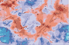
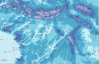
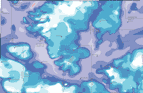
| The surficial, glacial geology of this region is dominated by the thick, complex sequence of deposits that occur in the Mahomet Bedrock Valley (marked by the orange and red areas on the map at left). The Mahomet Bedrock Valley was carved by rivers and by glaciers. As shown in other maps at this site, thick sand and gravel deposits in the Mahomet valley serve as aquifers, supplying groundwater to communities in the region. As shown below, this Valley is mostly filled with the pre-Illinois Episode deposits. [A diagram and explanation of geologic names is available (and will open in a new browser window).] The Valley continued to be filled with glacial deposits during the Illinois Episode, as indicated by the thickest accumulations. During the most recent glaciation, the Wisconsin Episode, the Valley had been completely filled, and the thickest sediments were deposited under the end moraines. Those features mark the positions where, during their advances and retreats across the landscape, the glaciers paused for some time, and deposited sediment at their margins.
|