By design, the North American Stratigraphic Code is meant
to be an evolving document, one that requires change as the field
of earth science evolves. The revisions to the Code that are included
in this 2005 edition encompass a broad spectrum of changes, ranging
from a complete revision of the section on Biostratigraphic
Units (Articles 48 to 54),
several wording changes to Article 58
and its remarks concerning Allostratigraphic Units, updating
of Article 4 to incorporate changes in
publishing methods over the last two decades, and a variety of
minor wording changes to improve clarity and self-consistency
between different sections of the Code. In addition, Figures 1, 4, 5 and 6, as
well as Tables 1 and 2
have been modified. Most of the changes adopted in this revision
arose from Notes 60, 63 and 64 of the Commission, all of which
were published in the AAPG Bulletin. These changes follow
Code amendment procedures as outlined in Article
21.
We hope these changes make the Code a more useable document to
professionals and students alike. Suggestions for future modifications
or additions to the North American Stratigraphic Code are always
welcome. Suggested and adopted modifications will be announced
to the profession, as in the past, by serial Notes and Reports
published in the AAPG Bulletin. Suggestions may be made
to representatives of your association or agency who are current
commissioners, or directly to the Commission itself. The Commission
meets annually, during the national meetings of the Geological
Society of America.
2004 NORTH AMERICAN COMMISSION ON STRATIGRAPHIC NOMENCLATURE
The 1983 Code of recommended procedures for classifying and naming stratigraphic and related units was prepared during a four-year period, by and for North American earth scientists, under the auspices of the North American Commission on Stratigraphic Nomenclature. It represents the thought and work of scores of persons, and thousands of hours of writing and editing. Opportunities to participate in and review the work have been provided throughout its development, as cited in the Preamble, to a degree unprecedented during preparation of earlier codes.
Publication of the International Stratigraphic Guide in 1976 made evident some insufficiencies of the American Stratigraphic Codes of 1961 and 1970. The Commission considered whether to discard our codes, patch them over, or rewrite them fully, and chose the last. We believe it desirable to sponsor a code of stratigraphic practice for use in North America, for we can adapt to new methods and points of view more rapidly than a worldwide body. A timely example was the recognized need to develop modes of establishing formal nonstratiform (igneous and high-grade metamorphic) rock units, an objective that is met in this Code, but not yet in the Guide.
The ways in which the 1983 Code (revised 2005) differs from earlier American codes are evident from the Contents. Some categories have disappeared and others are new, but this Code has evolved from earlier codes and from the International Stratigraphic Guide. Some new units have not yet stood the test of long practice, and conceivably may not, but they are introduced toward meeting recognized and defined needs of the profession. Take this Code, use it, but do not condemn it because it contains something new or not of direct interest to you. Innovations that prove unacceptable to the profession will expire without damage to other concepts and procedures, just as did the geologic-climate units of the 1961 Code.
Te 1983 Code was necessarily somewhat innovative because of: (1) the decision to write a new code, rather than to revise the 1970 Code; (2) the open invitation to members of the geologic profession to offer suggestions and ideas, both in writing and orally; and (3) the progress in the earth sciences since completion of previous codes. This report strives to incorporate the strength and acceptance of established practice, with suggestions for meeting future needs perceived by our colleagues; its authors have attempted to bring together the good from the past, the lessons of the Guide, and carefully reasoned provisions for the immediate future.
Participants in preparation of the 1983 Code are listed in Appendix I, but many others helped with their suggestions and comments. Major contributions were made by the members, and especially the chairmen, of the named subcommittees and advisory groups under the guidance of the Code Committee, chaired by Steven S. Oriel, who also served as principal, but not sole, editor. Amidst the noteworthy contributions by many, those of James D. Aitken have been outstanding. The work was performed for and supported by the Commission, chaired by Malcolm P. Weiss from 1978 to 1982.
This Code is the product of a truly North American effort. Many former and current commissioners representing not only the ten organizational members of the North American Commission on Stratigraphic Nomenclature (Appendix II), but other institutions as well, generated the product. Endorsement by constituent organizations is anticipated, and scientific communication will be fostered if Canadian, United States, and Mexican scientists, editors, and administrators consult Code recommendations for guidance in scientific reports. The Commission will appreciate reports of formal adoption or endorsement of the Code, and asks that they be transmitted to the Chairman of the Commission (c/o American Association of Petroleum Geologists, Box 979, Tulsa, Oklahoma 74101, U.S.A.).
Any code necessarily represents but a stage in the evolution of scientific communication. Suggestions for future changes of, or additions to, the North American Stratigraphic Code are welcome. Suggested and adopted modifications will be announced to the profession, as in the past, by serial Notes and Reports published in the AAPG Bulletin. Suggestions may be made to representatives of your association or agency who are current commissioners, or directly to the Commission itself. The Commission meets annually, during the national meetings of the Geological Society of America.
1982 NORTH AMERICAN COMMISSION ON STRATIGRAPHIC NOMENCLATURE
PART I: PREAMBLE
BACKGROUND
OVERVIEW
Material Categories Based on Content or Physical Limits
PART II: ARTICLES
INTRODUCTION
GENERAL PROCEDURES
DEFINITION OF FORMAL UNITS
Article 3. Requirements for Formally Named Geologic Units
Remarks:
Remark:
Remark:
Remarks:
a. Appropriate geographic terms
c. Priority and preservation of established names
Remarks:
Remarks:
Article 11. Historical Background
Article 12. Dimensions and Regional Relations
Remarks:
Article 16. Surface and Subsea Units
Remarks:
REVISION AND ABANDONMENT OF FORMAL UNITS
Article 17. Requirements for Major Changes
Remark:
Remarks:
Remarks:
c. Examples of changes from area to area
d. Example of change in single area
Remarks:
CODE AMENDMENT
FORMAL UNITS DISTINGUISHED BY CONTENT, PROPERTIES, OR PHYSICAL LIMITS
LITHOSTRATIGRAPHIC UNITS
Nature and Boundaries
Article 22. Nature of Lithostratigraphic Units
Remarks:
d. Independence from inferred geologic history
e. Independence from time concepts
g. Economically exploited units
Remarks:
a. Boundary in a vertically gradational sequence
b. Boundaries in lateral lithologic change
c. Key beds used for boundaries
Ranks of Lithostratigraphic Units
Remarks:
e. Organic reefs and carbonate mounds
Remarks:
Remarks:
Remarks:
Remark:
Lithostratigraphic Nomenclature
Article 30. Compound Character
Remarks:
LITHODEMIC UNITS
Nature and Boundaries
Article 31. Nature of Lithodemic Units
Remarks:
b. Type and reference localities
Remark:
Ranks of Lithodemic Units
Remarks:
Article 34. Division of Lithodemes
Remarks:
Remarks:
Article 38. Misuse of "Series" for Suite, Complex, or Supersuite
Lithodemic Nomenclature
Article 39. General Provisions
Remarks:
MAGNETO STRATIGRAPHIC UNITS
Nature and Boundaries
Article 43. Nature of Magnetostratigraphic Units
Remarks:
Article 44. Definition of Magnetopolarity Unit
Remarks:
c. Independence on inferred history
d. Relation to lithostratigraphic and biostratigraphic units
e. Relation of magnetopolarity units to chronostratigraphic units
Remark:
Ranks of Magnetopolarity Units
Remarks:
Magnetopolarity Nomenclature
BIOSTRATIGRAPHIC UNITS
Preamble
Remark:
Nature and Boundaries
Article 49. Nature of Biostratigraphic Units
Remarks:
b. Contemporaneity of rocks and fossils
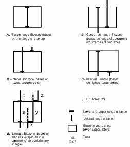
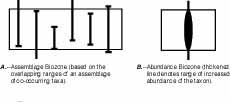
Article 50. Kinds of Biostratigraphic Units
Remarks:
Remark:
Ranks of Biostratigraphic Units
Remarks:
Biostratigraphic Nomenclature
Article 54. Establishing Formal Units
Remarks:
PEDOSTRATIGRAPHIC UNITS
Nature and Boundaries
Article 55. Nature of Pedostratigraphic Units
Remarks:
c. Boundaries and stratigraphic position
e. Distinction from pedologic soils
f. Relation to saprolite and other weathered materials
Pedostratigraphic Nomenclature and Unit
Remarks:
c. Procedures for establishing formal pedostratigraphic units
ALLOSTRATIGRAPHIC UNITS
Nature and boundaries
Article 58. Nature of Allostratigraphic Units
Remarks:
g. Relation to geomorphic surfaces
h. Relation to soils and paleosols
Ranks of Allostratigraphic Units
Remarks:
Allostratigraphic Nomenclature
Remark:
FORMAL UNITS DISTINGUISHED BY AGE
GEOLOGIC-TIME UNITS
Nature and Kinds
Units Based on Material Referents
Article 62. Kinds Based on Referents
Article 63. Isochronous Categories
Remark:
Article 64. Diachronous Categories
Remarks:
Units Independent of Material Referents
CHRONOSTRATIGRAPHIC UNITS
Nature and Boundaries
Remarks:
Remark:
a. Emphasis on lower boundaries of chronostratigraphic units
Ranks of Chronostratigraphic Units
Remark:
Remark:
Remark:
Remarks:
Chronostratigraphic Nomenclature
Remarks:
GEOCHRONOLOGIC UNITS
Nature and Boundaries
Ranks and Nomenclature of Geochronologic Units
POLARITY-CHRONOSTRATIGRAPHIC UNITS
Nature and Boundaries
Remarks:
Ranks and Nomenclature of Polarity-Chronostratigraphic Units
Remarks:
Article 86. Establishing Formal Units
Remarks:
POLARITY-CHRONOLOGIC UNITS
Nature and Boundaries
Ranks and Nomenclature of Polarity-Chronologic Units
Remark:
DIACHRONIC UNITS
Nature and Boundaries
Remarks:
Remark:
Ranks and Nomenclature of Diachronic Units
Remarks:
Remarks:
a. Formal designation of units
Article 95. Establishing Formal Units
Remark:
GEOCHRONOMETRIC UNITS
Nature and Boundaries
Ranks and Nomenclature of Geochronometric Units
PART III: ADDENDA
APPENDICES
I. PARTICIPANTS AND CONFEREES IN CODE REVISION
II. 1977-1982 COMPOSITION OF THE NORTH AMERICAN COMMISSION ON STRATIGRAPHIC NOMENCLATURE
III. REPORTS AND NOTES OF THE AMERICAN COMMISSION ON STRATIGRAPHIC NOMENCLATURE
ILLUSTRATIONS
TABLES
FIGURES
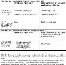
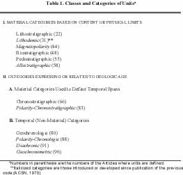
1. Relation of geologic time units to the kinds of material-referents on which most are based
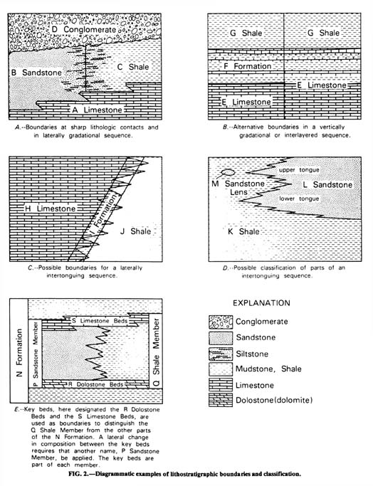
2. Diagrammatic examples of lithostratigraphic boundaries and classification
3. Lithodemic and lithostratigraphic units
4. Examples of range, lineage, and interval zones
5. Examples of assemblage and abundance zones
6. Relationship between pedostratigraphic units and pedologic profiles
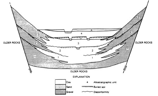
7. Example of allostratigraphic classification of alluvial and lacustrine deposits in a graben
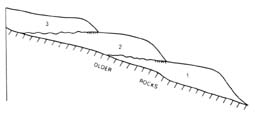
8. Example of allostratigraphic classification of contiguous deposits of similar lithology
10. Comparison of geochronologic, chronostratigraphic, and diachronic units
Codes of Stratigraphic Nomenclature prepared by the North American Commission on Stratigraphic Nomenclature in 1983, the American Commission on Stratigraphic Nomenclature (ACSN, 1961) and its predecessor (Committee on Stratigraphic Nomenclature, 1933) have been used widely as a basis for stratigraphic terminology. Their formulation was a response to needs recognized during the past century by government surveys (both national and local) and by editors of scientific journals for uniform standards and common procedures in defining and classifying formal rock bodies, their fossils, and the time spans represented by them. The 1970 Code (ACSN, 1970) is a slightly revised version of that published in 1961, incorporating some minor amendments adopted by the Commission between 1962 and 1969. The 2005 edition of the 1983 Code incorporates amendments adopted by the Commission between 1983 and 2003. The Codes have served the profession admirably and have been drawn upon heavily for codes and guides prepared in other parts of the world (ISSC, 1976, p. 104-106; 1994, p. 143-147). The principles embodied by any code, however, reflect the state of knowledge at the time of its preparation.
New concepts and techniques developed since 1961 have revolutionized the earth sciences. Moreover, increasingly evident have been the limitations of previous codes in meeting some needs of Precambrian and Quaternary geology and in classification of plutonic, high-grade metamorphic, volcanic, and intensely deformed rock assemblages. In addition, the important contributions of numerous international stratigraphic organizations associated with both the International Union of Geological Sciences (IUGS) and UNESCO, including working groups of the International Geological Correlation Programme (IGCP), merit recognition and incorporation into a North American code.
For these and other reasons, revision of the 1970 Code was undertaken by committees appointed by the North American Commission on Stratigraphic Nomenclature (NACSN). The Commission, founded as the American Commission on Stratigraphic Nomenclature in 1946 (ACSN, 1947), was renamed the NACSN in 1978 (Weiss, 1979b) to emphasize that delegates from ten organizations in Canada, the United States, and Mexico represent the geological profession throughout North America (Appendix II).
Although many past and current members of the Commission helped prepare the 1983 Code, the participation of all interested geologists was sought (for example, Weiss, 1979a). Open forums were held at the national meetings of both the Geological Society of America at San Diego in November, 1979, and the American Association of Petroleum Geologists at Denver in June, 1980, at which comments and suggestions were offered by more than 150 geologists. The resulting draft of this report was printed, through the courtesy of the Canadian Society of Petroleum Geologists, on October 1, 1981, and additional comments were invited from the profession for a period of one year before submittal of this report to the Commission for adoption. More than 50 responses were received with sufficient suggestions for improvement to prompt moderate revision of the printed draft (NACSN, 1981). We are particularly indebted to Hollis D. Hedberg and Amos Salvador for their exhaustive and perceptive reviews of early drafts of this Code, as well as to those who responded to the request for comments. Participants in the preparation and revisions of this report, and conferees, are listed in Appendix I.
Recent amendments to the 1983 Code include allowing electronic publication of new and revised names and correcting inconsistencies to improve clarity (Ferrusquia-Villafranca et al., 2001). Also, the Biostratigraphic Units section (Articles 48 to 54) was revised (Lenz et al., 2001).
Some of the expenses incurred in the course of this work were defrayed by National Science Foundation Grant EAR 7919845, for which we express appreciation. Institutions represented by the participants have been especially generous in their support.
The North American Stratigraphic Code seeks to describe explicit practices for classifying and naming all formally defined geologic units. Stratigraphic procedures and principles, although developed initially to bring order to strata and the events recorded therein, are applicable to all earth materials, not solely to strata. They promote systematic and rigorous study of the composition, geometry, sequence, history, and genesis of rocks and unconsolidated materials. They provide the framework within which time and space relations among rock bodies that constitute the Earth are ordered systematically. Stratigraphic procedures are used not only to reconstruct the history of the Earth and of extra-terrestrial bodies, but also to define the distribution and geometry of some commodities needed by society. Stratigraphic classification systematically arranges and partitions bodies of rock or unconsolidated materials of the Earth's crust into units on the basis of their inherent properties or attributes.
A stratigraphic code or guide is a formulation of current views on stratigraphic principles and procedures designed to promote standardized classification and formal nomenclature of rock materials. It provides the basis for formalization of the language used to denote rock units and their spatial and temporal relations. To be effective, a code must be widely accepted and used; geologic organizations and journals may adopt its recommendations for nomenclatural procedure. Because any code embodies only current concepts and principles, it should have the flexibility to provide for both changes and additions to improve its relevance to new scientific problems.
Any system of nomenclature must be sufficiently explicit to enable users to distinguish objects that are embraced in a class from those that are not. This stratigraphic code makes no attempt to systematize structural, petrographic, paleontologic, or physiographic terms. Terms from these other fields that are used as part of formal stratigraphic names should be sufficiently general as to be unaffected by revisions of precise petrographic or other classifications.
The objective of a system of classification is to promote unambiguous communication in a manner not so restrictive as to inhibit scientific progress. To minimize ambiguity, a code must promote recognition of the distinction between observable features (reproducible data) and inferences or interpretations. Moreover, it should be sufficiently adaptable and flexible to promote the further development of science.
Stratigraphic classification promotes understanding of the geometry and sequence of rock bodies. The development of stratigraphy as a science required formulation of the Law of Superposition to explain sequential stratal relations. Although superposition is not applicable to many igneous, metamorphic, and tectonic rock assemblages, other criteria (such as cross-cutting relations and isotopic dating) can be used to determine sequential arrangements among rock bodies.
The term stratigraphic unit may be defined in several ways. Etymological emphasis requires that it be a stratum or assemblage of adjacent strata distinguished by any or several of the many properties that rocks may possess (ISSC, 1976, p. 13; 1994, p. 13). The scope of stratigraphic classification and procedures, however, suggests a broader definition: a naturally occurring body of rock or rock material distinguished from adjoining bodies of rock on the basis of some stated property or properties. Commonly used properties include composition, texture, included fossils, magnetic signature, radioactivity, seismic velocity, and age. Sufficient care is required in defining the boundaries of a unit to enable others to distinguish the material body from those adjoining it. Units based on one property commonly do not coincide with those based on another and, therefore, distinctive terms are needed to identify the property used in defining each unit.
The adjective stratigraphic is used in two ways in the remainder of this report. In discussions of lithic (used here as synonymous with "lithologic") units, a conscious attempt is made to restrict the term to lithostratigraphic or layered rocks and sequences that obey the Law of Superposition. For nonstratiform rocks (of plutonic or tectonic origin, for example), the term lithodemic (see Article 27) is used. The adjective stratigraphic is also used in a broader sense to refer to those procedures derived from stratigraphy which are now applied to all classes of earth materials.
An assumption made in the material that follows is that the reader has some degree of familiarity with basic principles of stratigraphy as outlined, for example, by Dunbar and Rodgers (1957), Weller (1960), Shaw (1964), Matthews (1974), Blatt et al. (1990), Boggs (2001), or the International Stratigraphic Guide (ISSC, 1976, 1994).
RELATION OF CODES TO INTERNATIONAL GUIDE
Publication of the International Stratigraphic Guide by the International Subcommission on Stratigraphic Classification (ISSC, 1976), which is being endorsed and adopted throughout the world, played a part in prompting examination of the American Stratigraphic Code and the decision to revise it.
The International Guide embodies principles and procedures that had been adopted by several national and regional stratigraphic committees and commissions. More than two decades of effort by H.D. Hedberg and other members of the Subcommission (ISSC, 1976, p. VI, 1, 3) developed the consensus required for preparation of the Guide. Although the Guide attempts to cover all kinds of rocks and the diverse ways of investigating them, it is necessarily incomplete. Mechanisms are needed to stimulate individual innovations toward promulgating new concepts, principles, and practices that subsequently may be found worthy of inclusion in later editions of the Guide. The flexibility of national and regional committees or commissions enables them to perform this function more readily than an international subcommission, even while they adopt the Guide as the international standard of stratigraphic classification.
A guiding principle in preparing this Code has been to make it as consistent as possible with the International Guide, and at the same time to foster further innovations to meet the expanding and changing needs of earth scientists on the North American continent.
An attempt is made to strike a balance between serving the needs of those in evolving specialties and resisting the proliferation of categories of units. Consequently, additional formal categories are recognized here relative to previous codes or in the International Guide (ISSC, 1994). On the other hand, no special provision is made for formalizing certain kinds of units (deep oceanic, for example) that may be accommodated by available categories.
Four principal categories of units have previously been used widely in traditional stratigraphic work; these have been termed lithostratigraphic, biostratigraphic, chronostratigraphic, and geochronologic and are distinguished as follows:
1. A lithostratigraphic unit is a stratum or body of strata, generally but not invariably layered, generally but not invariably tabular, that conforms to the Law of Superposition and is distinguished and delimited on the basis of lithic characteristics and stratigraphic position. Example: Navajo Sandstone.
2. A biostratigraphic unit is a body of rock defined and characterized by its fossil content. Example: Discoaster multiradiatus Interval Biozone.
3. A chronostratigraphic unit is a body of rock established to serve as the material reference for all rocks formed during the same span of time. Example: Devonian System. Each boundary of a chronostratigraphic unit is synchronous. Chronostratigraphy provides a means of organizing strata into units based on their age relations. A chronostratigraphic body also serves as the basis for defining the specific interval of geologic time, or geochronologic unit, represented by the referent.
4. A geochronologic unit is a division of time distinguished on the basis of the rock record preserved in a chronostratigraphic unit. Example: Devonian Period.
The first two categories are comparable in that they consist of material units defined on the basis of content. The third category differs from the first two in that it serves primarily as the standard for recognizing and isolating materials of a specific age. The fourth, in contrast, is not a material, but rather a conceptual, unit; it is a division of time. Although a geochronologic unit is not a stratigraphic body, it is so intimately tied to chronostratigraphy that the two are discussed properly together.
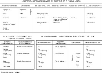
Properties and procedures that may be used in distinguishing geologic units are both diverse and numerous (ISSC, 1976, p. 1, 96;1994, p. 102-103; Harland, 1977, p. 230), but all may be assigned to the following principal classes of categories used in stratigraphic classification (Table 1), which are discussed below:
I. Material categories based on content, inherent attributes, or physical limits
II. Categories expressing or related to geologic age
A. Material categories used to define temporal spans
B. Temporal (non-material) categories
Table 1. Classes and Categories of Units*
[Click on table for enlarged view]
Material Categories Based on Content or Physical Limits
The basic building blocks for most geologic work are rock bodies defined on the basis of composition and related lithic characteristics, or on their physical, chemical, or biologic content or properties. Emphasis is placed on the relative objectivity and reproducibility of data used in defining units within each category.
Foremost properties of rocks are composition, texture, fabric, structure, and color, which together are designated lithic characteristics. These serve as the basis for distinguishing and defining the most fundamental of all formal units. Such units based primarily on composition are divided into two categories (Henderson and others, 1980): lithostratigraphic (Article 22) and lithodemic (defined here in Article 31). A lithostratigraphic unit obeys the Law of Superposition, whereas a lithodemic unit does not. A lithodemic unit is a defined body of predominantly intrusive, highly metamorphosed, or intensely deformed rock that, because it is intrusive or has lost primary structure through metamorphism or tectonism, generally does not conform to the Law of Superposition.
Recognition during the past several decades that remanent magnetism in rocks records the Earth's past magnetic characteristics (Cox, Doell, and Dalrymple, 1963) provides a powerful new tool encompassed by magnetostratigraphy (McDougall, 1977; McElhinny, 1978). Magnetostratigraphy (Article 43) is the study of remanent magnetism in rocks; it is the record of the Earth's magnetic polarity (or field reversals), dipole-field-pole position (including apparent polar wander), the non-dipole component (secular variation), and field intensity. Polarity is of particular utility and is used to define a magnetopolarity unit (Article 44) as a body of rock identified by its remanent magnetic polarity (ACSN, 1976; ISSC, 1979). Empirical demonstration of uniform polarity does not necessarily have direct temporal connotations because the remanent magnetism need not be related to rock deposition or crystallization. Nevertheless, polarity is a physical attribute that may characterize a body of rock.
Biologic remains contained in, or forming, strata are uniquely important in stratigraphic practice. First, they provide the means of defining and recognizing material units based on fossil content (biostratigraphic units). Second, the irreversibility of organic evolution makes it possible to partition enclosing strata temporally. Third, biologic remains provide important data for the reconstruction of ancient environments of deposition.
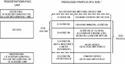
Composition also is important in distinguishing pedostratigraphic units. A pedostratigraphic unit is a body of rock that consists of one or more pedologic horizons developed in one or more lithic units now buried by a formally defined lithostratigraphic or allostratigraphic unit or units. A pedostratigraphic unit is the part of a buried soil characterized by one or more clearly defined soil horizons containing pedogenically formed minerals and organic compounds. Pedostratigraphic terminology is discussed below and in Article 55.
Many upper Cenozoic, especially Quaternary, deposits are distinguished and delineated on the basis of content, for which lithostratigraphic classification is appropriate. However, others are delineated on the basis of criteria other than content. To facilitate the reconstruction of geologic history, some compositionally similar deposits in vertical sequence merit distinction as separate stratigraphic units because they are the products of different processes; others merit distinction because they are of demonstrably different ages. Lithostratigraphic classification of these units is impractical and a new approach, allostratigraphic classification, is introduced here and may prove applicable to older deposits as well. An allostratigraphic unit is a mappable stratiform body of sedimentary rock defined and identified on the basis of bounding discontinuities (Article 58 and related Remarks).
Geologic-Climate units, defined in the 1970 Code (ACSN, 1970, p. 31), were abandoned in the 1983 Code because they proved to be of dubious utility. Inferences regarding climate are subjective and too tenuous a basis for the definition of formal geologic units. Such inferences commonly are based on deposits assigned more appropriately to lithostratigraphic or allostratigraphic units and may be expressed in terms of diachronic units (defined below).
Categories Expressing or Related to Geologic Age
Time is a single, irreversible continuum. Nevertheless, various categories of units are used to define intervals of geologic time, just as terms having different bases, such as Paleolithic, Renaissance, and Elizabethan, are used to designate specific periods of human history. Different temporal categories are established to express intervals of time distinguished in different ways.
Major objectives of stratigraphic classification are to provide a basis for systematic ordering of the time and space relations of rock bodies and to establish a time framework for the discussion of geologic history. For such purposes, units of geologic time traditionally have been named to represent the span of time during which a well-described sequence of rock, or a chronostratigraphic unit, was deposited ("time units based on material referents," Fig. 1). This procedure continues, to the exclusion of other possible approaches, to be standard practice in studies of Phanerozoic rocks. Despite admonitions in previous American codes and the International Stratigraphic Guide (ISSC, 1976, p. 81; 1994, p. 87) that similar procedures should be applied to the Precambrian, no comparable chronostratigraphic units, or geochronologic units derived therefrom, proposed for the Precambrian have yet been accepted worldwide. Instead, the IUGS Subcommission on Precambrian Stratigraphy (Sims, 1979) and its Working Groups (Harrison and Peterman, 1980) recommend division of Precambrian time into geochronometric units having no material referents.
FIG. 1. -Relation of geologic time units to the kinds of material-referents on which most are based.
[Click on figure for enlarged view]
A distinction is made throughout this report between isochronous and synchronous, as urged by Cumming, Fuller, and Porter (1959, p. 730), although the terms have been used synonymously by many. Isochronous means of equal duration; synchronous means simultaneous, or occurring at the same time. Although two rock bodies of very different ages may be formed during equal durations of time, the term isochronous is not applied to them in the earth sciences. Rather, isochronous bodies are those bounded by synchronous surfaces and formed during the same span of time. Isochron, in contrast, is used for a line connecting points of equal age on a graph representing physical or chemical phenomena; the line represents the same or equal time. The adjective diachronous is applied either to a rock unit with one or two bounding surfaces which are not synchronous, or to a boundary which is not synchronous (which "transgresses time").
Two classes of time units based on material referents, or stratotypes, are recognized (Fig. 1). The first is that of the traditional and conceptually isochronous units, and includes geochronologic units, which are based on chronostratigraphic units, and polarity-geochronologic units. These isochronous units have worldwide applicability and may be used even in areas lacking a material record of the named span of time. The second class of time units, newly defined in this Code, consists of diachronic units (Article 91), which are based on rock bodies known to be diachronous. In contrast to isochronous units, a diachronic term is used only where a material referent is present; a diachronic unit is coextensive with the material body or bodies on which it is based.
A chronostratigraphic unit, as defined above and in Article 66, is a body of rock established to serve as the material reference for all rocks formed during the same span of time; its boundaries are synchronous. It is the referent for a geochronologic unit, as defined above and in Article 80. Internationally accepted and traditional chronostratigraphic units were based initially on the time spans of lithostratigraphic units, biostratigraphic units, or other features of the rock record that have specific durations. In sum, they form the Standard Global Chronostratigraphic Scale (ISSC, 1976, p. 76-81; 1994, p. 85; Harland, 1978), consisting of established systems and series.
A polarity-chronostratigraphic unit is a body of rock that contains a primary magnetopolarity record imposed when the rock was deposited or crystallized (Article 83). It serves as a material standard or referent for a part of geologic time during which the Earth's magnetic field had a characteristic polarity or sequence of polarities; that is, for a polarity-chronologic unit (Article 88).
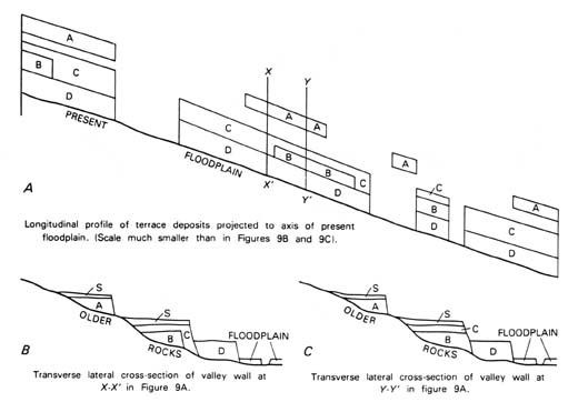
A diachronic unit comprises the unequal spans of time represented by one or more specific diachronous rock bodies (Article 91). Such bodies may be lithostratigraphic, biostratigraphic, pedostratigraphic, allostratigraphic, or an assemblage of such units. A diachronic unit is applicable only where its material referent is present.
A geochronometric (or chronometric) unit is an isochronous direct division of geologic time expressed in years (Article 96). It has no material referent.
The definition and nomenclature for pedostratigraphic units2 in this Code differ from those for soil-stratigraphic units in the previous Code (ACSN, 1970, Article 18), by being more specific with regard to content, boundaries, and the basis for determining stratigraphic position.
The term "soil" has different meanings to the geologist, the soil scientist, the engineer, and the layman, and commonly has no stratigraphic significance. The term paleosol is currently used in North America for any soil that formed on a landscape of the past; it may be a buried soil, a relict soil, or an exhumed soil (Ruhe, 1965; Valentine and Dalrymple, 1976).
A pedologic soil is composed of one or more soil horizons3. A soil horizon is a layer within a pedologic soil that (1) is approximately parallel to the soil surface, (2) has distinctive physical, chemical, biological, and morphological properties that differ from those of adjacent, genetically related, soil horizons, and (3) is distinguished from other soil horizons by objective compositional properties that can be observed or measured in the field. The physical boundaries of buried pedologic horizons are objective traceable boundaries with stratigraphic significance. A buried pedologic soil provides the material basis for definition of a stratigraphic unit in pedostratigraphic classification (Article 55), but a buried pedologic soil may be somewhat more inclusive than a pedostratigraphic unit. A pedologic soil may contain both an O-horizon and the entire C-horizon (Fig. 6), whereas the former is excluded and the latter need not be included in a pedostratigraphic unit.
The definition and nomenclature for pedostratigraphic units in this Code differ from those of soil stratigraphic units proposed by the International Union for Quaternary Research and International Society of Soil Science (Parsons, 1981). The pedostratigraphic unit, geosol, also differs from the proposed INQUA-ISSS soil-stratigraphic unit, pedoderm, in several ways, the most important of which are: (1) a geosol may be in any part of the geologic column, whereas a pedoderm is a surficial soil; (2) a geosol is a buried soil, whereas a pedoderm may be a buried, relict, or exhumed soil; (3) the boundaries and stratigraphic position of a geosol are defined and delineated by criteria that differ from those for a pedoderm; and (4) a geosol may be either all or only a part of a buried soil, whereas a pedoderm is the entire soil.
The term geosol, as defined by Morrison (1967, p. 3), is a laterally traceable, mappable, geologic weathering profile that has a consistent stratigraphic position. The term is adopted and redefined here as the fundamental and only unit in formal pedostratigraphic classification (Article 56).
2 From Greek, pedon, ground or soil.
3 As used in a geological sense, a horizon is a surface or line. In pedology, however, it is a body of material, and such usage is continued here.
Although the Code emphasizes formal categories of geologic units, informal nomenclature is highly useful in stratigraphic work.
Formally named units are those that are named in accordance with an established scheme of classification; the fact of formality is conveyed by capitalization of the initial letter of the rank or unit term (for example, Morrison Formation). Informal units, whose unit terms are ordinary nouns, are not protected by the stability provided by proper formalization and recommended classification procedures. Informal terms are devised for both economic and scientific reasons. Formalization is appropriate for those units requiring stability of nomenclature, particularly those likely to be extended far beyond the locality in which they were first recognized. Informal terms are appropriate for casually mentioned, innovative, and most economic units, those defined by unconventional criteria, and those that may be too thin to map at usual scales.
Casually mentioned geologic units not defined in accordance with this Code are informal. For many of these, there may be insufficient need or information, or perhaps an inappropriate basis, for formal designations. Informal designations as beds or lithozones (the pebbly beds, the shaly zone, third coal) are appropriate for many such units.
Most economic units, such as aquifers, oil sands, coal beds, quarry layers, and ore-bearing "reefs," are informal, even though they may be named. Some such units, however, are so significant scientifically and economically that they merit formal recognition as beds, members, or formations.
Innovative approaches in regional stratigraphic studies have resulted in the recognition and definition of units best left as informal, at least for the time being. Units bounded by major regional unconformities on the North American craton were designated "sequences" (example: Sauk sequence) by Sloss (1963). Major unconformity-bounded units also were designated "synthems" by Chang (1975), who recommended that they be treated formally. Marker-defined units that are continuous from one lithofacies to another were designated "formats" by Forgotson (1957). The term "chronosome" was proposed by Schultz (1982) for rocks of diverse facies corresponding to geographic variations in sedimentation during an interval of deposition identified on the basis of bounding stratigraphic markers. Successions of faunal zones containing evolutionally related forms, but bounded by non-evolutionary biotic discontinuities, were termed "biomeres" (Palmer, 1965). The foregoing are only a few selected examples to demonstrate how informality provides a continuing avenue for innovation.
The terms magnafacies and parvafacies, coined by Caster (1934) to emphasize the distinction between lithostratigraphic and chronostratigraphic units in sequences displaying marked facies variation, have remained informal despite their impact on clarifying the concepts involved.
Tephrochronologic studies provide examples of informal units too thin to map at conventional scales but yet invaluable for dating important geologic events. Although some such units are named for physiographic features and places where first recognized (e.g., Guaje pumice bed, where it is not mapped as the Guaje Member of the Bandelier Tuff), others bear the same name as the volcanic vent (e.g., Huckleberry Ridge ash bed of Izett and Wilcox, 1981).
Informal geologic units are designated by ordinary nouns, adjectives or geographic terms and lithic or unit-terms that are not capitalized (chalky formation or beds, St. Francis coal).
No geologic unit should be established and defined, whether formally or informally, unless its recognition serves a clear purpose.
Correlation is a procedure for demonstrating correspondence between geographically separated parts of a geologic unit. The term is a general one having diverse meanings in different disciplines. Demonstration of temporal correspondence is one of the most important objectives of stratigraphy. The term correlation frequently is misused to express the idea that a unit has been identified or recognized.
Correlation is used in this Code as the demonstration of correspondence between two geologic units in both some defined property and relative stratigraphic position. Because correspondence may be based on various properties, three kinds of correlation are best distinguished by more specific terms. Lithocorrelation links units of similar lithology and stratigraphic position (or sequential or geometric relation, for lithodemic units). Biocorrelation expresses similarity of fossil content and biostratigraphic position. Chronocorrelation expresses correspondence in age and in chronostratigraphic position.
Other terms that have been used for the similarity of content and stratal succession are homotaxy and chronotaxy. Homotaxy is the similarity in separate regions of the serial arrangement or succession of strata of comparable compositions or of included fossils. The term is derived from homotaxis, proposed by Huxley (1862, p. xlvi) to emphasize that similarity in succession does not prove age equivalence of comparable units. The term chronotaxy has been applied to similar stratigraphic sequences composed of units which are of equivalent age (Henbest, 1952, p. 310).
Criteria used for ascertaining temporal and other types of correspondence are diverse (ISSC, 1976, p. 86-93; 1994, p. 92-97) and new criteria will emerge in the future. Evolving statistical tests, as well as isotopic and paleomagnetic techniques, complement the traditional paleontologic and lithologic procedures. Boundaries defined by one set of criteria need not correspond to those defined by others.
Article 1. -Purpose. This Code describes explicit stratigraphic procedures for classifying and naming geologic units accorded formal status. Such procedures, if widely adopted, assure consistent and uniform usage in classification and terminology and therefore promote unambiguous communication.
Article 2. -Categories. Categories of formal stratigraphic units, though diverse, are of three classes. The first class (I on Table 1) is of rock-material categories based on content, inherent attributes, or physical limits, and includes lithostratigraphic, lithodemic, magnetopolarity, biostratigraphic, pedostratigraphic, and allostratigraphic units. The second class (IIA on Table 1) is of material categories used as standards for defining spans of geologic time, and includes chronostratigraphic and polarity-chronostratigraphic units. The third class (IIB on Table 1) is of non-material temporal categories, and includes geochronologic, polarity-chronologic, diachronic, and geochronometric units.
Article 3. -Requirements for Formally Named Geologic Units. Naming, establishing, revising, redefining, and abandoning formal geologic units require publication in a recognized scientific medium of a comprehensive statement which includes: (i) intent to designate or modify a formal unit; (ii) designation of category and rank of unit; (iii) selection and derivation of name; (iv) specification of stratotype (where applicable); (v) description of unit; (vi) definition of boundaries; (vii) historical background; (viii) dimensions, shape, and other regional aspects; (ix) geologic age; (x) correlations; and possibly (xi) genesis (where applicable). These requirements apply to subsurface and offshore, as well as exposed, units.
Table 2. Categories and Ranks of Units Defined in This Code*
*Fundamental units are italicized.
[Click on table for enlarged view]
Article 4. -Publication.4 "Publication in a recognized scientific medium" in conformance with this Code means that a work, when first issued, must (1) be reproduced in ink on paper; be reproduced electronically on CD-ROM, on the Internet, or by another electronic method widely accepted by the scientific community; or be reproduced by some method that assures numerous identical copies and wide distribution; (2) be issued for the purpose of scientific, public, permanent record; (3) be readily obtainable by purchase or free distribution; and (4) have undergone adequate peer review.
Remarks. (a) Inadequate publication. -The following do not constitute publication within the meaning of the Code: (1) distribution of microfilms, microcards, or matter reproduced by similar methods; (2) distribution to colleagues or students of a note, even if printed, in explanation of an accompanying illustration; (3) distribution of proof sheets; (4) open-file release; (5) theses, dissertations, and dissertation abstracts; (6) mention at a scientific or other meeting; (7) mention in an abstract, map explanation, or figure caption; (8) labeling of a rock specimen in a collection; (9) mere deposit of a document in a library; (10) anonymous publication; (11) mention in the popular press or in a legal document; or (12) distribution by an author by posting on the Internet, or by another electronic medium, a document that has not undergone the procedures stated below (Remark c).
(b) Guidebooks. -A guidebook with distribution limited to participants of a field excursion does not meet the test of availability. Some organizations publish and distribute widely large editions of serial guidebooks that include refereed regional papers; although these do meet the tests of scientific purpose and availability, and therefore constitute valid publication, other media are preferable.
(c) Electronic publication. -Publication in this medium, which has become widespread since distribution of the Code in 1983, is confined to publication in a journal or other publication series by a widely recognized (1) scientific society, (2) government agency, (3) academic institution, or (4) other respected scientific publisher. All versions distributed must be the same, whether in paper or electronic form, without alteration. Other requirements are as follows: (1) archival practices adequate for future availability; (2) suitable typography, (3) coding and markup practices that adhere to accepted standards, (4) database preparation that includes satisfactory search and retrieval tools as well as the capability for downloading to a researcher's local printer, and (5) adequate copyediting standards. New stratigraphic names can be published electronically.
4 This article is modified slightly from a statement by the International Commission of Zoological Nomenclature (1964, p. 7-9). Remark (c) is from the advice of the Association of Earth Science Editors.
Article 5. -Intent and Utility. To be valid, a new unit must serve a clear purpose and be duly proposed and duly described, and the intent to establish it must be specified. Casual mention of a unit, such as "the granite exposed near the Middleville schoolhouse," does not establish a new formal unit, nor does mere use in a table, columnar section, or map.
Remark. (a) Demonstration of purpose served. -The initial definition or revision of a named geologic unit constitutes, in essence, a proposal. As such, it lacks status until use by others demonstrates that a clear purpose has been served. A unit becomes established through repeated demonstration of its utility. The decision not to use a newly proposed or a newly revised term requires a full discussion of its unsuitability.
Article 6. -Category and Rank. The category and rank of a new or revised unit must be specified.
Remark. (a) Need for specification. -Many stratigraphic controversies have arisen from confusion or misinterpretation of the category of a unit (for example, lithostratigraphic vs. chronostratigraphic). Specification and unambiguous description of the category is of paramount importance. Selection and designation of an appropriate rank from the distinctive terminology developed for each category help serve this function (Table 2).
Article 7. -Name. The name of a formal geologic unit is compound. For most categories, the name of a unit should consist of a geographic name combined with an appropriate rank (Wasatch Formation) or descriptive term (Viola Limestone). Biostratigraphic units are designated by appropriate biologic forms (Exus albus Assemblage Biozone). Worldwide chronostratigraphic units bear long established and generally accepted names of diverse origins (Triassic System). The first letters of all words used in the names of formal geologic units are capitalized (except for the trivial species and subspecies terms in the name of a biostratigraphic unit).
Remarks. (a) Appropriate geographic terms. -Geographic names derived from permanent natural or artificial features at or near which the unit is present are preferable to those derived from impermanent features such as farms, schools, stores, churches, crossroads, and small communities. Appropriate names may be selected from those shown on topographic, state, provincial, county, forest service, hydrographic, or comparable maps, particularly those showing names approved by a national board for geographic names. The generic part of a geographic name, e.g., river, lake, village, should be omitted from new terms, unless required to distinguish between two otherwise identical names (e.g., Redstone Formation and Redstone River Formation). Two names should not be derived from the same geographic feature. A unit should not be named for the source of its components; for example, a deposit inferred to have been derived from the Keewatin glaciation center should not be designated the "Keewatin Till."
(b) Duplication of names. -Responsibility for avoiding duplication, either in use of the same name for different units (homonymy) or in use of different names for the same unit (synonomy), rests with the proposer. Although the same geographic term has been applied to different categories of units (example: the lithostratigraphic Word Formation and the chronostratigraphic Wordian Stage) now entrenched in the literature, the practice is undesirable. The extensive geologic nomenclature of North America, including not only names but also nomenclatural history of formal units, is recorded in compendia maintained by the Committee on Stratigraphic Nomenclature of the Geological Survey of Canada, Ottawa, Ontario; by the Geologic Names Committee of the United States Geological Survey, Reston, Virginia; by the Instituto de Geologia, Ciudad Universitaria, México, D.F.; and by many state and provincial geological surveys. These organizations respond to inquiries regarding the availability of names, and some are prepared to reserve names for units likely to be defined in the next year or two.
(c) Priority and preservation of established names. -Stability of nomenclature is maintained by use of the rule of priority and by preservation of well-established names. Names should not be modified without explaining the need. Priority in publication is to be respected, but priority alone does not justify displacing a well-established name by one neither well-known nor commonly used; nor should an inadequately established name be preserved merely on the basis of priority. Redefinitions in precise terms are preferable to abandonment of the names of well-established units which may have been defined imprecisely but nonetheless in conformance with older and less stringent standards.
(d) Differences of spelling and changes in name. -The geographic component of a well-established stratigraphic name is not changed due to differences in spelling or changes in the name of a geographic feature. The name Bennett Shale, for example, used for more than half a century, need not be altered because the town is named Bennet. Nor should the Mauch Chunk Formation be changed because the town has been renamed Jim Thorpe. Disappearance of an impermanent geographic feature, such as a town, does not affect the name of an established geologic unit.
(e) Names in different countries and different languages. -For geologic units that cross local and international boundaries, a single name for each is preferable to several. Spelling of a geographic name commonly conforms to the usage of the country and linguistic group involved. Although geographic names are not translated (Cuchillo is not translated to Knife), lithologic or rank terms are (Edwards Limestone, Caliza Edwards; Formación La Casita, La Casita Formation).
Article 8. -Stratotypes. The designation of a unit or boundary stratotype (type section or type locality) is essential in the definition of most formal geologic units. Many kinds of units are best defined by reference to an accessible and specific sequence of rock that may be examined and studied by others. A stratotype is the standard (original or subsequently designated) for a named geologic unit or boundary and constitutes the basis for definition or recognition of that unit or boundary; therefore, it must be illustrative and representative of the concept of the unit or boundary being defined.
Remarks. (a) Unit stratotypes. -A unit stratotype is the type section for a stratiform deposit or the type area for a nonstratiform body that serves as the standard for definition and recognition of a geologic unit. The upper and lower limits of a unit stratotype are designated points in a specific sequence or locality and serve as the standards for definition and recognition of a stratigraphic unit's boundaries.
(b) Boundary stratotype. -A boundary stratotype is the type locality for the boundary reference point for a stratigraphic unit. Both boundary stratotypes for any unit need not be in the same section or region. Each boundary stratotype serves as the standard for definition and recognition of the base of a stratigraphic unit. The top of a unit may be defined by the boundary stratotype of the next higher stratigraphic unit.
(c) Type locality. -A type locality is the specified geographic locality where the stratotype of a formal unit or unit boundary was originally defined and named. A type area is the geographic territory encompassing the type locality. Before the concept of a stratotype was developed, only type localities and areas were designated for many geologic units which are now long- and well-established. Stratotypes, though now mandatory in defining most stratiform units, are impractical in definitions of many large nonstratiform rock bodies whose diverse major components may be best displayed at several reference localities.
(d) Composite-stratotype. -A composite-stratotype consists of several reference sections (which may include a type section) required to demonstrate the range or totality of a stratigraphic unit.
(e) Reference sections. -Reference sections may serve as invaluable standards in definitions or revisions of formal geologic units. For those well-established stratigraphic units for which a type section never was specified, a principal reference section (lectostratotype of ISSC, 1976, p. 26; 1994, p. 28) may be designated. A principal reference section (neostratotype of ISSC, 1976, p. 26; 1994, p. 28) also may be designated for those units or boundaries whose stratotypes have been destroyed, covered, or otherwise made inaccessible. Supplementary reference sections often are designated to illustrate the diversity or heterogeneity of a defined unit or some critical feature not evident or exposed in the stratotype. Once a unit or boundary stratotype section is designated, it is never abandoned or changed; however, if a stratotype proves inadequate, it may be supplemented by a principal reference section or by several reference sections that may constitute a composite-stratotype.
(f) Stratotype descriptions. -Stratotypes should be described both geographically and geologically. Sufficient geographic detail must be included to enable others to find the stratotype in the field, and may consist of maps and (or) aerial photographs showing location and access, as well as appropriate coordinates or bearings. Geologic information should include thickness, descriptive criteria appropriate to the recognition of the unit and its boundaries, and discussion of the relation of the unit to other geologic units of the area. A carefully measured and described section provides the best foundation for definition of stratiform units. Graphic profiles, columnar sections, structure-sections, and photographs are useful supplements to a description; a geologic map of the area including the type locality is essential.
Article 9. -Unit Description. A unit proposed for formal status should be described and defined so clearly that any subsequent investigator can recognize that unit unequivocally. Distinguishing features that characterize a unit may include any or several of the following: composition, texture, primary structures, structural attitudes, biologic remains, readily apparent mineral composition (e.g., calcite vs. dolomite), geochemistry, geophysical properties (including magnetic signatures), geomorphic expression, unconformable or cross-cutting relations, and age. Although all distinguishing features pertinent to the unit category should be described sufficiently to characterize the unit, those not pertinent to the category (such as age and inferred genesis for lithostratigraphic units, or lithology for biostratigraphic units) should not be made part of the definition.
Article 10. -Boundaries. The criteria specified for the recognition of boundaries between adjoining geologic units are of paramount importance because they provide the basis for scientific reproducibility of results. Care is required in describing the criteria, which must be appropriate to the category of unit involved.
Remarks. (a) Boundaries between intergradational units. -Contacts between rocks of markedly contrasting composition are appropriate boundaries of lithic units, but some rocks grade into, or intertongue with, others of different lithology. Consequently, some boundaries are necessarily arbitrary as, for example, the top of the uppermost limestone in a sequence of interbedded limestone and shale. Such arbitrary boundaries commonly are diachronous.
(b) Overlaps and gaps. -The problem of overlaps and gaps between long-established adjacent chronostratigraphic units is being addressed by international IUGS and IGCP working groups appointed to deal with various parts of the geologic column. The procedure recommended by the Geological Society of London (George et al., 1969; Holland et al., 1978), of defining only the basal boundaries of chronostratigraphic units, has been widely adopted (e.g., McLaren, 1977) to resolve the problem. Such boundaries are defined by a carefully selected and agreed-upon boundary-stratotype (marker-point type section or "golden spike") that becomes the standard for the base of a chronostratigraphic unit. The concept of the mutual-boundary stratotype (ISSC, 1976, p. 84-86), redesignated lower-boundary stratotype (ISSC, 1994, p. 90), based on the assumption of continuous deposition in selected sequences, also has been used to define chronostratigraphic units.
Although international chronostratigraphic units of series and higher rank are being redefined by IUGS and IGCP working groups, there may be a continuing need for some provincial series. Adoption of the basal boundary-stratotype concept is urged.
Article 11. -Historical Background. A proposal for a new name must include a nomenclatorial history of constituent rocks assigned to the proposed unit, describing how they were treated previously and by whom (references), as well as such matters as priorities, possible synonymy, and other pertinent considerations. Consideration of the historical background of an older unit commonly provides the basis for justifying definition of a new unit.
Article 12. -Dimensions and Regional Relations. A perspective on the magnitude of a unit should be provided by such information as may be available on the geographic extent of a unit; observed ranges in thickness, composition, and geomorphic expression; relations to other kinds and ranks of stratigraphic units; correlations with other nearby sequences; and the bases for recognizing and extending the unit beyond the type locality. If the unit is not known anywhere but in an area of limited extent, informal designation is recommended.
Article 13. -Age. For most formal material geologic units, other than chronostratigraphic and polarity-chronostratigraphic, inferences regarding geologic age play no proper role in their definition. Nevertheless, the age, as well as the basis for its assignment, are important features of the unit and, where possible, should be stated. For many lithodemic units, the age of the protolith should be distinguished from that of the metamorphism or deformation. If the basis for assigning an age is tenuous, a doubt should be expressed.
Remarks. (a) Dating. -The geochronologic ordering of the rock record, whether in terms of radioactive-decay rates or other processes, is generally called "dating." However, the use of the noun "date" to mean "isotopic age" is not recommended. Similarly, the term "absolute age" should be suppressed in favor of "isotopic age" for an age determined on the basis of isotopic ratios. The more inclusive term "numerical age" is recommended for all ages determined from isotopic ratios, fission tracks, and other quantifiable age-related phenomena.
(b) Calibration. -The dating of chronostratigraphic boundaries in terms of numerical ages is a special form of dating for which the word "calibration" should be used. The geochronologic time-scale now in use has been developed mainly through such calibration of chronostratigraphic sequences.
(c) Convention and abbreviations. -The age of a stratigraphic unit or the time of a geologic event, as commonly determined by numerical dating or by reference to a calibrated time-scale, may be expressed in years before the present. The unit of time is the modern year as presently recognized worldwide. Recommended (but not mandatory) abbreviations for such ages are SI (International System of Units) multipliers coupled with "a" for annum: ka, Ma, and Ga5 for kilo-annum (103 years), Mega-annum (106 years), and Giga-annum (109 years), respectively. Use of these terms after the age value follows the convention established in the field of C-14 dating. The "present" refers to 1950 AD, and such qualifiers as "ago" or "before the present" are omitted after the value because measurement of the duration from the present to the past is implicit in the designation. In contrast, the duration of a remote interval of geologic time, as a number of years, should not be expressed by the same symbols. Abbreviations for numbers of years, without reference to the present, are informal (e.g., y or yr for years; my, m.y., or m.yr. for millions of years; and so forth, as preference dictates). For example, boundaries of the Late Cretaceous Epoch currently are calibrated at 63 Ma and 96 Ma, but the interval of time represented by this epoch is 33 m.y.
(d) Expression of "age" of lithodemic units. -The adjectives "early," "middle," and "late" should be used with the appropriate geochronologic term to designate the age of lithodemic units. For example, a granite dated isotopically at 510 Ma should be referred to using the geochronologic term "Late Cambrian granite" rather than either the chronostratigraphic term "Upper Cambrian granite" or the more cumbersome designation "granite of Late Cambrian age."
5 Note that the initial letters Mega- and Giga- are capitalized, but that of kilo- is not, by SI convention.
Article 14. -Correlation. Information regarding spatial and temporal counterparts of a newly defined unit beyond the type area provides readers with an enlarged perspective. Discussions of criteria used in correlating a unit with those in other areas should make clear the distinction between data and inferences.
Article 15. -Genesis. Objective data are used to define and classify geologic units and to express their spatial and temporal relations. Although many of the categories defined in this Code (e.g., lithostratigraphic group, plutonic suite) have genetic connotations, inferences regarding geologic history or specific environments of formation may play no proper role in the definition of a unit. However, observations, as well as inferences, that bear on genesis are of great interest to readers and should be discussed.
Article 16. -Subsurface and Subsea Units. The foregoing procedures for establishing formal geologic units apply also to subsurface and offshore or subsea units. Complete lithologic and paleontologic descriptions or logs of the samples or cores are required in written or graphic form, or both. Boundaries and divisions, if any, of the unit should be indicated clearly with their depths from an established datum.
Remarks. (a) Naming subsurface units. -A subsurface unit may be named for the borehole (Eagle Mills Formation), oil field (Smackover Limestone), or mine which is intended to serve as the stratotype, or for a nearby geographic feature. The hole or mine should be located precisely, both with map and exact geographic coordinates, and identified fully (operator or company, farm or lease block, dates drilled or mined, surface elevation and total depth, etc).
(b) Additional recommendations. -Inclusion of appropriate borehole geophysical logs is urged. Moreover, rock and fossil samples and cores and all pertinent accompanying materials should be stored, and available for examination, at appropriate federal, state, provincial, university, or museum depositories. For offshore or subsea units (Clipperton Formation of Tracey and others, 1971, p.22; Argo Salt of McIver, 1972, p. 57), the names of the project and vessel, depth of sea floor, and pertinent regional sampling and geophysical data should be added.
(c) Seismostratigraphic units. -High-resolution seismic methods now can delineate stratal geometry and continuity at a level of confidence not previously attainable. Accordingly, seismic surveys have come to be the principal adjunct of the drill in subsurface exploration. On the other hand, the method identifies rock types only broadly and by inference. Thus, formalization of units known only from seismic profiles is inappropriate. Once the stratigraphy is calibrated by drilling, the seismic method may provide objective well-to-well correlations.
REVISION AND ABANDONMENT OF FORMAL UNITS
Article 17. -Requirements for Major Changes. Formally defined and named geologic units may be redefined, revised, or abandoned, but revision and abandonment require as much justification as establishment of a new unit.
Remark. (a) Distinction between redefinition and revision. -Redefinition of a unit involves changing the view or emphasis on the content of the unit without changing the boundaries or rank, and differs only slightly from redescription. Neither redefinition nor redescription is considered revision. A redescription corrects an inadequate or inaccurate description, whereas a redefinition may change a descriptive (for example, lithologic) designation. Revision involves either minor changes in the definition of one or both boundaries or in the rank of a unit (normally, elevation to a higher rank). Correction of a misidentification of a unit outside its type area is neither redefinition nor revision.
Article 18. -Redefinition. A correction or change in the descriptive term applied to a stratigraphic or lithodemic unit is a redefinition which does not require a new geographic term.
Remarks. (a) Change in lithic designation. -Priority should not prevent more exact lithic designation if the original designation is not everywhere applicable; for example, the Niobrara Chalk changes gradually westward to a unit in which shale is prominent, for which the designation "Niobrara Shale" or "Formation" is more appropriate. Many carbonate formations originally designated "limestone" or "dolomite" are found to be geographically inconsistent as to prevailing rock type. The appropriate lithic term or "formation" is again preferable for such units.
(b) Original lithic designation inappropriate. -Restudy of some long-established lithostratigraphic units has shown that the original lithic designation was incorrect according to modern criteria; for example, some "shales" have the chemical and mineralogical composition of limestone, and some rocks described as felsic lavas now are understood to be welded tuffs. Such new knowledge is recognized by changing the lithic designation of the unit, while retaining the original geographic term. Similarly, changes in the classification of igneous rocks have resulted in recognition that rocks originally described as quartz monzonite now are more appropriately termed granite. Such lithic designations may be modernized when the new classification is widely adopted. If heterogeneous bodies of plutonic rock have been misleadingly identified with a single compositional term, such as "gabbro," the adoption of a neutral term, such as "intrusion" or "pluton," may be advisable.
Article 19. -Revision. Revision involves either minor changes in the definition of one or both boundaries of a unit, or in the unit's rank.
Remarks. (a) Boundary change. -Revision is justifiable if a minor change in boundary will make a unit more natural and useful. If revision modifies only a minor part of the content of a previously established unit, the original name may be retained.
(b) Change in rank. -Change in rank of a stratigraphic or temporal unit requires neither redefinition of its boundaries nor alteration of the geographic part of its name. A member may become a formation or vice versa, a formation may become a group or vice versa, and a lithodeme may become a suite or vice versa.
(c) Examples of changes from area to area. -The Conasauga Shale is recognized as a formation in Georgia and as a group in eastern Tennessee; the Osgood Formation, Laurel Limestone, and Waldron Shale in Indiana are classed as members of the Wayne Formation in a part of Tennessee; the Virgelle Sandstone is a formation in western Montana and a member of the Eagle Sandstone in central Montana; the Skull Creek Shale and the Newcastle Sandstone in North Dakota are members of the Ashville Formation in Manitoba.
(d) Example of change in single area. -The rank of a unit may be changed without changing its content. For example, the Madison Limestone of early work in Montana later became the Madison Group, containing several formations.
(e) Retention of type section. -When the rank of a geologic unit is changed, the original type section or type locality is retained for the newly ranked unit (see Article 22c).
(f) Different geographic name for a unit and its parts. -In changing the rank of a unit, the same name may not be applied both to the unit as a whole and to a part of it. For example, the Astoria Group should not contain an Astoria Sandstone, nor the Washington Formation, a Washington Sandstone Member.
(g) Undesirable restriction. -When a unit is divided into two or more of the same rank as the original, the original name should not be used for any of the divisions. Retention of the old name for one of the units precludes use of the name in a term of higher rank. Furthermore, in order to understand an author's meaning, a later reader would have to know about the modification and its date, and whether the author is following the original or the modified usage. For these reasons, the normal practice is to raise the rank of an established unit when units of the same rank are recognized and mapped within it.
Article 20. -Abandonment. An improperly defined or obsolete stratigraphic, lithodemic, or temporal unit may be formally abandoned, provided that (a) sufficient justification is presented to demonstrate a concern for nomenclatural stability, and (b) recommendations are made for the classification and nomenclature to be used in its place.
Remarks. (a) Reasons for abandonment. -A formally defined unit may be abandoned by the demonstration of synonymy or homonymy, of assignment to an improper category (for example, definition of a lithostratigraphic unit in a chronostratigraphic sense), or of other direct violations of a stratigraphic code or procedures prevailing at the time of the original definition. Disuse, or the lack of need or useful purpose for a unit, may be a basis for abandonment; so, too, may widespread misuse in diverse ways which compound confusion. A unit also may be abandoned if it proves impracticable, neither recognizable nor mappable elsewhere.
(b) Abandoned names. -A name for a lithostratigraphic or lithodemic unit, once applied and then abandoned, is available for some other unit only if the name was introduced casually, or if it has been published only once in the last several decades and is not in current usage, and if its reintroduction will cause no confusion. An explanation of the history of the name and of the new usage should be a part of the designation.
(c) Obsolete names. -Authors may refer to national and provincial records of stratigraphic names to determine whether a name is obsolete (see Article 7b).
(d) Reference to abandoned names. -When it is useful to refer to an obsolete or abandoned formal name, its status is made clear by some such term as "abandoned" or "obsolete," and by using a phrase such as "La Plata Sandstone of Cross (1898)". (The same phrase also is used to convey that a named unit has not yet been adopted for usage by the organization involved.)
(e) Reinstatement. -A name abandoned for reasons that seem valid at the time, but which subsequently are found to be erroneous, may be reinstated. Example: the Washakie Formation, defined in 1869, was abandoned in 1918 and reinstated in 1973.
Article 21. -Procedure for Amendment. Additions to, or changes of, this Code may be proposed in writing to the Commission by any geoscientist at any time. If accepted for consideration by a majority vote of the Commission, they may be adopted by a two-thirds vote of the Commission at an annual meeting not less than a year after publication of the proposal.
Article 22. -Nature of Lithostratigraphic Units. A lithostratigraphic unit is a defined body of sedimentary, extrusive igneous, metasedimentary, or metavolcanic strata which is distinguished and delimited on the basis of lithic characteristics and stratigraphic position. A lithostratigraphic unit generally conforms to the Law of Superposition and commonly is stratified and tabular in form.
Remarks. (a) Basic units. -Lithostratigraphic units are the basic units of general geologic work and serve as the foundation for delineating strata, local and regional structure, economic resources, and geologic history in regions of stratified rocks. They are recognized and defined by observable rock characteristics; boundaries may be placed at clearly distinguished contacts or drawn arbitrarily within a zone of gradation. Lithification or cementation is not a necessary property; clay, gravel, till, and other unconsolidated deposits may constitute valid lithostratigraphic units.
(b) Type section and locality. -The definition of lithostratigraphic unit should be based, if possible, on a stratotype consisting of readily accessible rocks in place, e.g., in outcrops, excavations, and mines, or of rocks accessible only to remote sampling devices, such as those in drill holes and underwater. Even where remote methods are used, definitions must be based on lithic criteria and not on the geophysical characteristics of the rocks, nor the implied age of their contained fossils. Definitions must be based on descriptions of actual rock material. Regional validity must be demonstrated for all such units. In regions where the stratigraphy has been established through studies of surface exposures, the naming of new units in the subsurface is justified only where the subsurface section differs materially from the surface section, or where there is doubt as to the equivalence of a subsurface and a surface unit. The establishment of subsurface reference sections for units originally defined in outcrop is encouraged.
(c) Type section never changed. -The definition and name of a lithostratigraphic unit are established at a type section (or locality) that, once specified, must not be changed. If the type section is poorly designated or delimited, it may be redefined subsequently. If the originally specified stratotype is incomplete, poorly exposed, structurally complicated, or unrepresentative of the unit, a principal reference section or several reference sections may be designated to supplement, but not to supplant, the type section (Article 8e).
(d) Independence from inferred geologic history. -Inferred geologic history, depositional environment, and biological sequence have no place in the definition of a lithostratigraphic unit, which must be based on composition and other lithic characteristics; nevertheless, considerations of well-documented geologic history properly may influence the choice of vertical and lateral boundaries of a new unit. Fossils may be valuable during mapping in distinguishing between two lithologically similar, noncontiguous lithostratigraphic units. The fossil content of a lithostratigraphic unit is a legitimate lithic characteristic; for example, oyster-rich sandstone, coquina, coral reef, or graptolitic shale. Moreover, otherwise similar units, such as the Formación Mendez and Formación Velasco mudstones, may be distinguished on the basis of coarseness of contained fossils (Foraminifera).
(e) Independence from time concepts. -The boundaries of most lithostratigraphic units are time independent, but some may be approximately synchronous. Inferred time spans, however measured, play no part in differentiating or determining the boundaries of any lithostratigraphic unit. Either relatively short or relatively long intervals of time may be represented by a single unit. The accumulation of material assigned to a particular unit may have begun or ended earlier in some localities than in others; also, removal of rock by erosion, either within the time span of deposition of the unit or later, may reduce the time span represented by the unit locally. The body in some places may be entirely younger than in other places. On the other hand, the establishment of formal units that straddle known, identifiable, regional disconformities is to be avoided, if at all possible. Although concepts of time or age play no part in defining lithostratigraphic units nor in determining their boundaries, evidence of age may aid recognition of similar lithostratigraphic units at localities far removed from the type sections or areas.
(f) Surface form. -Erosional morphology or secondary surface form may be a factor in the recognition of a lithostratigraphic unit, but properly should play a minor part at most in the definition of such units. Because the surface expression of lithostratigraphic units is an important aid in mapping, it is commonly advisable, where other factors do not countervail, to define lithostratigraphic boundaries so as to coincide with lithic changes that are expressed in topography.
(g) Economically exploited units. -Aquifers, oil sands, coal beds, and quarry layers are, in general, informal units even though named. Some such units, however, may be recognized formally as beds, members, or formations because they are important in the elucidation of regional stratigraphy.
(h) Instrumentally defined units. -In subsurface investigations, certain bodies of rock and their boundaries are widely recognized on borehole geophysical logs showing their electrical resistivity, radioactivity, density, or other physical properties. Such bodies and their boundaries may or may not correspond to formal lithostratigraphic units and their boundaries. Where other considerations do not countervail, the boundaries of subsurface units should be defined so as to correspond to useful geophysical markers; nevertheless, units defined exclusively on the basis of remotely sensed physical properties, although commonly useful in stratigraphic analysis, stand completely apart from the hierarchy of formal lithostratigraphic units and are considered informal.
(i) Zone. -As applied to the designation of lithostratigraphic units, the term "zone" is informal. Examples are "producing zone," "mineralized zone," "metamorphic zone," and "heavy-mineral zone." A zone may include all or parts of a bed, a member, a formation, or even a group.
(j) Cyclothems. -Cyclic or rhythmic sequences of sedimentary rocks, whose repetitive divisions have been named cyclothems, have been recognized in sedimentary basins around the world. Some cyclothems have been identified by geographic names, but such names are considered informal. A clear distinction must be maintained between the division of a stratigraphic column into cyclothems and its division into groups, formations, and members. Where a cyclothem is identified by a geographic name, the word cyclothem should be part of the name, and the geographic term should not be the same as that of any formal unit embraced by the cyclothem.
(k) Soils and paleosols. -Soils and paleosols are layers composed of the in-situ products of weathering of older rocks which may be of diverse composition and age. Soils and paleosols differ in several respects from lithostratigraphic units, and should not be treated as such (see "Pedostratigraphic Units," Articles 55 et seq).
(1) Depositional facies. 3/4 Depositional facies are informal units, whether objective (conglomeratic, black shale, graptolitic) or genetic and environmental (platform, turbiditic, fluvial), even when a geographic term has been applied, e.g., Lantz Mills facies. Descriptive designations convey more information than geographic terms and are preferable.
Article 23. 3/4 Boundaries. Boundaries of lithostratigraphic units are placed at positions of lithic change. Boundaries are placed at distinct contacts or may be selected at some arbitrary level within zones of gradation (Fig. 2a). Both vertical and lateral boundaries are based on the lithic criteria that provide the greatest unity and utility.
Remarks. (a) Boundary in a vertically gradational sequence. -A named lithostratigraphic unit is preferably bounded by a single lower and a single upper surface so that the name does not recur in a normal stratigraphic succession (see Remark b). Where a rock unit passes vertically into another by intergrading or interfingering of two or more kinds of rock, unless the gradational strata are sufficiently thick to warrant designation of a third, independent unit, the boundary is necessarily arbitrary and should be selected on the basis of practicality (Fig. 2b). For example, where a shale unit overlies a unit of interbedded limestone and shale, the boundary commonly is placed at the top of the highest readily traceable limestone bed. Where a sandstone unit grades upward into shale, the boundary may be so gradational as to be difficult to place even arbitrarily; ideally it should be drawn at the level where the rock is composed of one-half of each component. Because of creep in outcrops and caving in boreholes, it is generally best to define such arbitrary boundaries by the highest occurrence of a particular rock type, rather than the lowest.
(b) Boundaries in lateral lithologic change. -Where a unit changes laterally through gradation into, or intertongues with, a markedly different kind of rock, a new unit should be proposed for the different rock type. An arbitrary lateral boundary may be placed between the two equivalent units. Where the area of lateral intergradation or intertonguing is sufficiently extensive, a transitional interval of interbedded rocks may constitute a third independent unit (Fig. 2c). Where tongues (Article 25b) of formations are mapped separately or otherwise set apart without being formally named, the unmodified formation name should not be repeated in a normal stratigraphic sequence, although the modified name may be repeated in such phrases as "lower tongue of Mancos Shale" and "upper tongue of Mancos Shale." To show the order of superposition on maps and cross sections, the unnamed tongues may be distinguished informally (Fig. 2d) by number, letter, or other means. Such relationships may also be dealt with informally through the recognition of depositional facies (Article 22l).
(c) Key beds used for boundaries. -Key beds (Article 26b) may be used as boundaries for a formal lithostratigraphic unit where the internal lithic characteristics of the unit remain relatively constant. Even though bounding key beds may be traceable beyond the area of the diagnostic overall rock type, geographic extension of the lithostratigraphic unit bounded thereby is not necessarily justified. Where the rock between key beds becomes drastically different from that of the type locality, a new name should be applied (Fig. 2e), even though the key beds are continuous (Article 26b). Stratigraphic and sedimentologic studies of stratigraphic units (usually informal) bounded by key beds may be very informative and useful, especially in subsurface work where the key beds may be recognized by their geophysical signatures. Such units, however, may be a kind of chronostratigraphic, rather than lithostratigraphic, unit (Article 75, 75c), although others are diachronous because one, or both, of the key beds are also diachronous.
FIG. 2. -Diagrammatic examples of lithostratigraphic boundaries and classification.
[Click on figure for enlarged view]
(d) Unconformities as boundaries. -Unconformities, where recognizable objectively on lithic criteria, are ideal boundaries for lithostratigraphic units. However, a sequence of similar rocks may include an obscure unconformity so that separation into two units may be desirable but impracticable. If no lithic distinction adequate to define a widely recognizable boundary can be made, only one unit should be recognized, even though it may include rock that accumulated in different epochs, periods, or eras.
(e) Correspondence with genetic units. -The boundaries of lithostratigraphic units should be chosen on the basis of lithic changes and, where feasible, to correspond with the boundaries of genetic units, so that subsequent studies of genesis will not have to deal with units that straddle formal boundaries.
Ranks of Lithostratigraphic Units
Article 24. -Formation. The formation is the fundamental unit in lithostratigraphic classification. A formation is a body of rock identified by lithic characteristics and stratigraphic position; it is prevailingly but not necessarily tabular and is mappable at the Earth's surface or traceable in the subsurface.
Remarks. (a) Fundamental unit. -Formations are the basic lithostratigraphic units used in describing and interpreting the geology of a region. The limits of a formation normally are those surfaces of lithic change that give it the greatest practicable unity of constitution. A formation may represent a long or short time interval, may be composed of materials from one or several sources, and may include breaks in deposition (see Article 23d).
(b) Content. -A formation should possess some degree of internal lithic homogeneity or distinctive lithic features. It may contain between its upper and lower limits (i) rock of one lithic type, (ii) repetitions of two or more lithic types, or (iii) extreme lithic heterogeneity which in itself may constitute a form of unity when compared to the adjacent rock units.
(c) Lithic characteristics. -Distinctive lithic characteristics include chemical and mineralogical composition, texture, and such supplementary features as color, primary sedimentary or volcanic structures, fossils (viewed as rock-forming particles), or other organic content (coal, oil-shale). A unit distinguishable only by the taxonomy of its fossils is not a lithostratigraphic but a biostratigraphic unit (Article 48). Rock type may be distinctively represented by electrical, radioactive, seismic, or other properties (Article 22h), but these properties by themselves do not describe adequately the lithic character of the unit.
(d) Mappability and thickness. -The proposal of a new formation must be based on tested mappability. Well-established formations commonly are divisible into several widely recognizable lithostratigraphic units; where formal recognition of these smaller units serves a useful purpose, they may be established as members and beds, for which the requirement of mappability is not mandatory. A unit formally recognized as a formation in one area may be treated elsewhere as a group, or as a member of another formation, without change of name. Example: the Niobrara is mapped at different places as a member of the Mancos Shale, of the Cody Shale, or of the Colorado Shale, and also as the Niobrara Formation, as the Niobrara Limestone, and as the Niobrara Shale.
Thickness is not a determining parameter in dividing a rock succession into formations; the thickness of a formation may range from a feather edge at its depositional or erosional limit to thousands of meters elsewhere. No formation is considered valid that cannot be delineated at the scale of geologic mapping practiced in the region when the formation is proposed. Although representation of a formation on maps and cross sections by a labeled line may be justified, proliferation of such exceptionally thin units is undesirable. The methods of subsurface mapping permit delineation of units much thinner than those usually practicable for surface studies; before such thin units are formalized, consideration should be given to the effect on subsequent surface and subsurface studies.
(e) Organic reefs and carbonate mounds. -Organic reefs and carbonate mounds ("buildups") may be distinguished formally, if desirable, as formations distinct from their surrounding, thinner, temporal equivalents. For the requirements of formalization, see Article 30f.
(f) Interbedded volcanic and sedimentary rock. -Sedimentary rock and volcanic rock that are interbedded may be assembled into a formation under one name which should indicate the predominant or distinguishing lithology, such as Mindego Basalt.
(g) Volcanic rock. -Mappable distinguishable sequences of stratified volcanic rock should be treated as formations or lithostratigraphic units of higher or lower rank. A small intrusive component of a dominantly stratiform volcanic assemblage may be treated informally.
(h) Metamorphic rock. -Formations composed of low-grade metamorphic rock (defined for this purpose as rock in which primary structures are clearly recognizable) are, like sedimentary formations, distinguished mainly by lithic characteristics. The mineral facies may differ from place to place, but these variations do not require definition of a new formation. High-grade metamorphic rocks whose relation to established formations is uncertain are treated as lithodemic units (see Articles 31 et seq).
Article 25. -Member. A member is the formal lithostratigraphic unit next in rank below a formation and is always a part of some formation. It is recognized as a named entity within a formation because it possesses characteristics distinguishing it from adjacent parts of the formation. A formation need not be divided into members unless a useful purpose is served by doing so. Some formations may be divided completely into members; others may have only certain parts designated as members; still others may have no members. A member may extend laterally from one formation to another.
Remarks. (a) Mapping of member. -A member is established when it is advantageous to recognize a particular part of a heterogeneous formation. A member, whether formally or informally designated, need not be mappable at the scale required for formations. Even if all members of a formation are locally mappable, it does not follow that they should be raised to formational rank, because proliferation of formation names may obscure rather than clarify relations with other areas.
(b) Lens and tongue. -A geographically restricted member that terminates on all sides within a formation may be called a lens (lentil). A wedging member that extends outward beyond a formation or wedges ("pinches") out within another formation may be called a tongue.
(c) Organic reefs and carbonate mounds. -Organic reefs and carbonate mounds may be distinguished formally, if desirable, as members within a formation. For the requirements of formalization, see Article 30f.
(d) Division of members. -A formally or informally recognized division of a member is called a bed or beds, except for volcanic flow rocks, for which the smallest formal unit is a flow. Members may contain beds or flows, but may never contain other members.
(e) Laterally equivalent members. -Although members normally are in vertical sequence, laterally equivalent parts of a formation that differ recognizably may also be considered members.
Article 26. -Bed(s). A bed, or beds, is the smallest formal lithostratigraphic unit of sedimentary rocks.
Remarks. (a) Limitations. -The designation of a bed or a unit of beds as a formally named lithostratigraphic unit generally should be limited to certain distinctive beds whose recognition is particularly useful. Coal beds, oil sands, and other beds of economic importance commonly are named, but such units and their names usually are not a part of formal stratigraphic nomenclature (Articles 22g and 30g).
(b) Key or marker beds. -A key or marker bed is a thin bed of distinctive rock that is widely distributed. Such beds may be named, but usually are considered informal units. Individual key beds may be traced beyond the lateral limits of a particular formal unit (Article 23c).
Article 27. -Flow. A flow is the smallest formal lithostratigraphic unit of volcanic flow rocks. A flow is a discrete, extrusive, volcanic body distinguishable by texture, composition, order of superposition, paleomagnetism, or other objective criteria. It is part of a member and thus is equivalent in rank to a bed or beds of sedimentary-rock classification. Many flows are informal units. The designation and naming of flows as formal rock-stratigraphic units should be limited to those that are distinctive and widespread.
Article 28. -Group. A group is the lithostratigraphic unit next higher in rank to formation; a group may consist entirely of named formations, or alternatively, need not be composed entirely of named formations.
Remarks. (a) Use and content. -Groups are defined to express the natural relationships of associated formations. They are useful in small-scale mapping and regional stratigraphic analysis. In some reconnaissance work, the term "group" has been applied to lithostratigraphic units that appear to be divisible into formations, but have not yet been so divided. In such cases, formations may be erected subsequently for one or all of the practical divisions of the group.
(b) Change in component formations. -The formations making up a group need not necessarily be everywhere the same. The Rundle Group, for example, is widespread in western Canada and undergoes several changes in formational content. In southwestern Alberta, it comprises the Livingstone, Mount Head, and Etherington Formations in the Front Ranges, whereas in the foothills and subsurface of the adjacent plains, it comprises the Pekisko, Shunda, Turner Valley, and Mount Head Formations. However, a formation or its parts may not be assigned to two vertically adjacent groups.
(c) Change in rank. -The wedge-out of a component formation or formations may justify the reduction of a group to formation rank, retaining the same name. When a group is extended laterally beyond where it is divided into formations, it becomes in effect a formation, even if it is still called a group. When a previously established formation is divided into two or more component units that are given formal formation rank, the old formation, with its old geographic name, should be raised to group status. Raising the rank of the unit is preferable to restricting the old name to a part of its former content, because a change in rank leaves the sense of a well-established unit unchanged (Articles 19b, 19g).
Article 29. -Supergroup. A supergroup is a formal assemblage of related or superposed groups, or of groups and formations. Such units have proved useful in regional and provincial syntheses. Supergroups should be named only where their recognition serves a clear purpose.
Remark. (a) Misuse of "series" for group or supergroup. -Although "series" is a useful general term, it is applied formally only to a chronostratigraphic unit and should not be used for a lithostratigraphic unit. The term "series" should no longer be employed for an assemblage of formations or an assemblage of formations and groups, as it has been, especially in studies of the Precambrian. These assemblages are groups or supergroups.
Lithostratigraphic Nomenclature
Article 30. -Compound Character. The formal name of a lithostratigraphic unit is compound. It consists of a geographic name combined with a descriptive lithic term or with the appropriate rank term, or both. Initial letters of all words used in forming the names of formal rock-stratigraphic units are capitalized.
Remarks. (a) Omission of part of a name. -Where frequent repetition would be cumbersome, the geographic name, the lithic term, or the rank term may be used alone, once the full name has been introduced; as "the Burlington," "the limestone," or "the formation," for the Burlington Limestone.
(b) Use of simple lithic terms. -The lithic part of the name should indicate the predominant or diagnostic lithology, even if subordinate lithologies are included. Where a lithic term is used in the name of a lithostratigraphic unit, the simplest generally acceptable term is recommended (for example, limestone, sandstone, shale, tuff, quartzite). Compound terms (for example, clay shale) and terms that are not in common usage (for example, calcirudite, orthoquartzite) should be avoided. Combined terms, such as "sand and clay," should not be used for the lithic part of the names of lithostratigraphic units, nor should an adjective be used between the geographic and the lithic terms, as "Chattanooga Black Shale" and "Biwabik Iron-Bearing Formation."
(c) Group names. -A group name combines a geographic name with the term "group," and no lithic designation is included; for example, San Rafael Group.
(d) Formation names. -A formation name consists of a geographic name followed by a lithic designation or by the word "formation." Examples: Dakota Sandstone, Mitchell Mesa Rhyolite, Monmouth Formation, Halton Till.
(e) Member names. -All member names include a geographic term and the word "member;" some have an intervening lithic designation, if useful; for example, Wedington Sandstone Member of the Fayetteville Shale. Members designated solely by lithic character (for example, siliceous shale member), by position (upper, lower), or by letter or number, are informal.
(f) Names of reefs. -Organic reefs identified as formations or members are formal units only where the name combines a geographic name with the appropriate rank term, e.g., Leduc Formation (a name applied to the several reefs enveloped by the Ireton Formation), Rainbow Reef Member.
(g) Bed and flow names. -The names of beds or flows combine a geographic term, a lithic term, and the term "bed" or "flow;" for example, Knee Hills Tuff Bed, Ardmore Bentonite Beds, Negus Variolitic Flows.
(h) Informal units. -When geographic names are applied to such informal units as oil sands, coal beds, mineralized zones, and informal members (see Articles 22g and 26a), the unit term should not be capitalized. A name is not necessarily formal because it is capitalized, nor does failure to capitalize a name render it informal. Geographic names should be combined with the terms "formation" or "group" only in formal nomenclature.
(i) Informal usage of identical geographic names. -The application of identical geographic names to several minor units in one vertical sequence is considered informal nomenclature (lower Mount Savage coal, Mount Savage fireclay, upper Mount Savage coal, Mount Savage rider coal, and Mount Savage sandstone). The application of identical geographic names to the several lithologic units constituting a cyclothem likewise is considered informal.
(j) Metamorphic rock. -Metamorphic rock recognized as a normal stratified sequence, commonly low-grade metavolcanic or metasedimentary rocks, should be assigned to named groups, formations, and members, such as the Deception Rhyolite, a formation of the Ash Creek Group, or the Bonner Quartzite, a formation of the Missoula Group. High-grade metamorphic and metasomatic rocks are treated as lithodemes and suites (see Articles 31, 33, 35).
(k) Misuse of well-known name. -A name that suggests some well-known locality, region, or political division should not be applied to a unit typically developed in another less well-known locality of the same name. For example, it would be inadvisable to use the name "Chicago Formation" for a unit in California.
LITHODEMIC UNITS
Nature and Boundaries
Article 31. -Nature of Lithodemic Units. A lithodemic6 unit is a defined body of predominantly intrusive, highly deformed, and (or) highly metamorphosed rock, distinguished and delimited on the basis of rock characteristics. In contrast to lithostratigraphic units, a lithodemic unit generally does not conform to the Law of Superposition. Its contacts with other rock units may be sedimentary, extrusive, intrusive, tectonic, or metamorphic (Fig. 3).
Remarks. (a) Recognition and definition. -Lithodemic units are defined and recognized by observable rock characteristics. They are the practical units of general geological work in terranes in which rock bodies generally lack primary stratification; in such terranes they serve as the foundation for studying, describing, and delineating lithology, local and regional structure, economic resources, and geologic history.
(b) Type and reference localities. -The definition of a lithodemic unit should be based on as full a knowledge as possible of its lateral and vertical variations and its contact relationships. For purposes of nomenclatural stability, a type locality and, wherever appropriate, reference localities should be designated.
(c) Independence from inferred geologic history. -Concepts based on inferred geologic history properly play no part in the definition of a lithodemic unit. Nevertheless, where two rock masses are lithically similar but display objective structural relations that preclude the possibility of their being even broadly of the same age, they should be assigned to different lithodemic units.
(d) Use of "zone." -As applied to the designation of lithodemic units, the term "zone" is informal. Examples are: "mineralized zone," "contact zone," and "pegmatitic zone."
6 From the Greek demas, -os: "living body, frame".
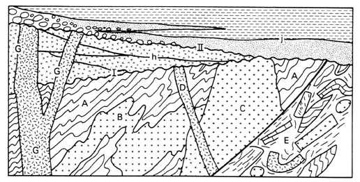
FIG. 3. - Lithodemic (upper case) and lithostratigraphic (lower case) units. A lithodeme of gneiss (A) contains an intrusion of diorite (B) that was deformed with the gneiss. A and B may be treated jointly as a complex. A younger granite (C) is cut by a dike of syenite (D), that is cut in turn by unconformity I. All the foregoing are in fault contact with a structural complex (E). A volcanic complex (G) is built upon unconformity I, and its feeder dikes cut the unconformity. Laterally equivalent volcanic strata in orderly, mappable succession (h) are treated as lithostratigraphic units. A gabbro feeder (G'), to the volcanic complex, where surrounded by gneiss is readily distinguished as a separate lithodeme and named as a gabbro or an intrusion. All the foregoing are overlain, at unconformity II, by sedimentary rocks (j) divided into formations and members.
[Click on figure for enlarged view]
Article 32. -Boundaries. Boundaries of lithodemic units are placed at positions of lithic change. They may be placed at clearly distinguished contacts or within zones of gradation. Boundaries, both vertical and lateral, are based on the lithic criteria that provide the greatest unity and practical utility. Contacts with other lithodemic and lithostratigraphic units may be depositional, intrusive, metamorphic, or tectonic.
Remark. (a) Boundaries within gradational zones. -Where a lithodemic unit changes through gradation into, or intertongues with, a rock mass with markedly different characteristics, it is usually desirable to propose a new unit. It may be necessary to draw an arbitrary boundary within the zone of gradation. Where the area of intergradation or intertonguing is sufficiently extensive, the rocks of mixed character may constitute a third unit.
Ranks of Lithodemic Units
Article 33. -Lithodeme. The lithodeme is the fundamental unit in lithodemic classification. A lithodeme is a body of intrusive, pervasively deformed, or highly metamorphosed rock, generally non-tabular and lacking primary depositional structures, and characterized by lithic homogeneity. It is mappable at the Earth's surface and traceable in the subsurface. For cartographic and hierarchical purposes, it is comparable to a formation (see Table 2).
Remarks. (a) Content. -A lithodeme should possess distinctive lithic features and some degree of internal lithic homogeneity. It may consist of (i) rock of one type, (ii) a mixture of rocks of two or more types, or (iii) extreme heterogeneity of composition, which may constitute in itself a form of unity when compared to adjoining rock-masses (see also "complex," Article 37).
(b) Lithic characteristics. -Distinctive lithic characteristics may include mineralogy, textural features such as grain size, and structural features such as schistose or gneissic structure. A unit distinguishable from its neighbors only by means of chemical analysis is informal.
(c) Mappability. -Practicability of surface or subsurface mapping is an essential characteristic of a lithodeme (see Article 24d).
Article 34. -Division of Lithodemes. Units below the rank of lithodeme are informal.
Article 35. -Suite. A suite (metamorphic suite, intrusive suite, plutonic suite) is the lithodemic unit next higher in rank to lithodeme. It comprises two or more associated lithodemes of the same class (e.g., plutonic, metamorphic). For cartographic and hierarchical purposes, suite is comparable to group (see Table 2).
Remarks. (a) Purpose. -Suites are recognized for the purpose of expressing the natural relations of associated lithodemes having significant lithic features in common, and of depicting geology at compilation scales too small to allow delineation of individual lithodemes. Ideally, a suite consists entirely of named lithodemes, but may contain both named and unnamed units.
(b) Change in component units. -The named and unnamed units constituting a suite may change from place to place, so long as the original sense of natural relations and of common lithic features is not violated.
(c) Change in rank. -Traced laterally, a suite may lose all of its formally named divisions but remain a recognizable, mappable entity. Under such circumstances, it may be treated as a lithodeme but retain the same name. Conversely, when a previously established lithodeme is divided into two or more mappable divisions, it may be desirable to raise its rank to suite, retaining the original geographic component of the name. To avoid confusion, the original name should not be retained for one of the divisions of the original unit (see Article 19g).
Article 36. -Supersuite. A supersuite is the unit next higher in rank to a suite. It comprises two or more suites or complexes having a degree of natural relationship to one another, either in the vertical or the lateral sense. For cartographic and hierarchical purposes, supersuite is similar in rank to supergroup.
Article 37. -Complex. An assemblage or mixture of rocks of two or more genetic classes, i.e., igneous, sedimentary, or metamorphic, with or without highly complicated structure, may be named a complex. The term "complex" takes the place of the lithic or rank term (for example, Boil Mountain Complex, Franciscan Complex) and, although unranked, commonly is comparable to suite or supersuite and is named in the same manner (Articles 41, 42).
Remarks. (a) Use of "complex." -Identification of an assemblage of diverse rocks as a complex is useful where the mapping of each separate lithic component is impractical at ordinary mapping scales. "Complex" is unranked but commonly comparable to suite or supersuite; therefore, the term may be retained if subsequent, detailed mapping distinguishes some or all of the component lithodemes or lithostratigraphic units.
(b) Volcanic complex. -Sites of persistent volcanic activity commonly are characterized by a diverse assemblage of extrusive volcanic rocks, related intrusions, and their weathering products. Such an assemblage may be designated a volcanic complex.
(c) Structural complex. -In some terranes, tectonic processes (e.g., shearing, faulting) have produced heterogeneous mixtures or disrupted bodies of rock in which some individual components are too small to be mapped. Where there is no doubt that the mixing or disruption is due to tectonic processes, such a mixture may be designated as a structural complex, whether it consists of two or more classes of rock, or a single class only. A simpler solution for some mapping purposes is to indicate intense deformation by an overprinted pattern.
(d) Misuse of "complex". -Where the rock assemblage to be united under a single, formal name consists of diverse types of a single class of rock, as in many terranes that expose a variety of either intrusive igneous or high-grade metamorphic rocks, the term "intrusive suite," "plutonic suite," or "metamorphic suite" should be used, rather than the unmodified term "complex." Exceptions to this rule are the terms structural complex and volcanic complex (see Remarks c and b, above).
Article 38. -Misuse of "Series" for Suite, Complex, or Supersuite. The term "series" has been employed for an assemblage of lithodemes or an assemblage of lithodemes and suites, especially in studies of the Precambrian. This practice now is regarded as improper; these assemblages are suites, complexes, or supersuites. The term "series" also has been applied to a sequence of rocks resulting from a succession of eruptions or intrusions. In these cases a different term should be used; "group" should replace "series" for volcanic and low-grade metamorphic rocks, and "intrusive suite" or "plutonic suite" should replace "series" for intrusive rocks of group rank.
Lithodemic Nomenclature
Article 39. -General Provisions. The formal name of a lithodemic unit is compound. It consists of a geographic name combined with a descriptive or appropriate rank term. The principles for the selection of the geographic term, concerning suitability, availability, priority, etc, follow those established in Article 7, where the rules for capitalization are also specified.
Article 40. -Lithodeme Names. The name of a lithodeme combines a geographic term with a lithic or descriptive term, e.g., Killarney Granite, Adamant Pluton, Manhattan Schist, Skaergaard Intrusion, Duluth Gabbro. The term formation should not be used.
Remarks. (a) Lithic term. -The lithic term should be a common and familiar term, such as schist, gneiss, gabbro. Specialized terms and terms not widely used, such as websterite and jacupirangite, and compound terms, such as graphitic schist and augen gneiss, should be avoided.
(b) Intensive and plutonic rocks. -Because many bodies of intrusive rock range in composition from place to place and are difficult to characterize with a single lithic term, and because many bodies of plutonic rock are considered not to be intrusions, latitude is allowed in the choice of a lithic or descriptive term. Thus, the descriptive term should preferably be compositional (e.g., gabbro, granodiorite), but may, if necessary, denote form (e.g., dike, sill), or be neutral (e.g., intrusion, pluton7). In any event, specialized compositional terms not widely used are to be avoided, as are form terms that are not widely used, such as bysmalith and chonolith. Terms implying genesis should be avoided as much as possible, because interpretations of genesis may change.
7 Pluton-a mappable body of plutonic rock.
Article 41.-Suite Names. The name of a suite combines a geographic term, the term " suite, " and an adjective denoting the fundamental character of the suite; for example, Idaho Springs Metamorphic Suite, Tuolumne Intrusive Suite, Cassiar Plutonic Suite. The geographic name of a suite may not be the same as that of a component lithodeme (see Article 19f). Intrusive assemblages, however, may share the same geographic name if an intrusive lithodeme is representative of the suite. (e.g. the Methuen Plutonic Suite may include the Methuen, Deloro, Abinger and Addington Granites, Easton, 1992. As the Methuen Granite, a lithodeme, is typical of the suite, the duplication of names is permissible).
Article 42. -Supersuite Names. The name of a supersuite combines a geographic term with the term "supersuite."
MAGNETOSTRATIGRAPHIC UNITS
Nature and Boundaries
Article 43. -Nature of Magnetostratigraphic Units. A magnetostratigraphic unit is a body of rock unified by specified remanent-magnetic properties and is distinct from underlying and overlying magnetostratigraphic units having different magnetic properties.
Remarks. (a) Definition. -Magnetostratigraphy is defined here as all aspects of stratigraphy based on remanent magnetism (paleomagnetic signatures). Four basic paleomagnetic phenomena can be determined or inferred from remanent magnetism: polarity, dipole-field-pole position (including apparent polar wander), the non-dipole component (secular variation), and field intensity.
(b) Contemporaneity of rock and remanent magnetism. -Many paleomagnetic signatures reflect earth magnetism at the time the rock formed. Nevertheless, some rocks have been subjected subsequently to physical and (or) chemical processes which altered the magnetic properties. For example, a body of rock may be heated above the blocking temperature or Curie point for one or more minerals, or a ferromagnetic mineral may be produced by low-temperature alteration long after the enclosing rock formed, thus acquiring a component of remanent magnetism reflecting the field at the time of alteration, rather than the time of original rock deposition or crystallization.
(c) Designations and scope. -The prefix magneto is used with an appropriate term to designate the aspect of remanent magnetism used to define a unit. The terms "magnetointensity" or "magnetosecular-variation" are possible examples. This Code considers only polarity reversals, which now are recognized widely as a stratigraphic tool. However, apparent-polar-wander paths offer increasing promise for correlations within Precambrian rocks.
Article 44. -Definition of Magnetopolarity Unit. A magnetopolarity unit is a body of rock unified by its remanent magnetic polarity and distinguished from adjacent rock bodies that have different polarity.
Remarks. (a) Nature. -Magnetopolarity is the record in rocks of the polarity history of the Earth's magnetic-dipole field. Frequent past reversals of the polarity of the Earth's magnetic field provide a basis for magnetopolarity stratigraphy.
(b) Stratotype. -A stratotype for a magnetopolarity unit should be designated and the boundaries defined in terms of recognized lithostratigraphic and (or) biostratigraphic units in the stratotype. The formal definition of a magnetopolarity unit should meet the applicable specific requirements of Articles 3 to 16.
(c) Independence from inferred history. -Definition of a magnetopolarity unit does not require knowledge of the time at which the unit acquired its remanent magnetism; its magnetism may be primary or secondary. Nevertheless, the unit's present polarity is a property that may be ascertained and confirmed by others.
(d) Relation to lithostratigraphic and biostratigraphic units. -Magnetopolarity units resemble lithostratigraphic and biostratigraphic units in that they are defined on the basis of an objective recognizable property, but differ fundamentally in that most magnetopolarity unit boundaries are thought not to be time transgressive. Their boundaries may coincide with those of lithostratigraphic or biostratigraphic units, or be parallel to but displaced from those of such units, or be crossed by them.
(e) Relation of magnetopolarity units to chronostratigraphic units. -Although transitions between polarity reversals are of global extent, a magnetopolarity unit does not contain within itself evidence that the polarity is primary, or criteria that permit its unequivocal recognition in chronocorrelative strata of other areas. Other criteria, such as paleontologic or numerical age, are required for both correlation and dating. Although polarity reversals are useful in recognizing chronostratigraphic units, magnetopolarity alone is insufficient for their definition.
Article 45. -Boundaries. The upper and lower limits of a magnetopolarity unit are defined by boundaries marking a change of polarity. Such boundaries may represent either a depositional discontinuity or a magnetic-field transition. The boundaries are either polarity-reversal horizons or polarity transition-zones, respectively.
Remark. (a) Polarity-reversal horizons and transition-zones. -A polarity-reversal horizon is either a single, clearly definable surface or a thin body of strata constituting a transitional interval across which a change in magnetic polarity is recorded. Polarity-reversal horizons describe transitional intervals of 1 m or less; where the change in polarity takes place over a stratigraphic interval greater than 1 m, the term "polarity transition-zone" should be used. Polarity-reversal horizons and polarity transition-zones provide the boundaries for polarity zones, although they may also be contained within a polarity zone where they mark an internal change subsidiary in rank to those at its boundaries.
Ranks of Magnetopolarity Units
Article 46. -Fundamental Unit. A polarity zone is the fundamental unit of magnetopolarity classification. A polarity zone is a unit of rock characterized by the polarity of its magnetic signature. Magnetopolarity zone, rather than polarity zone, should be used where there is risk of confusion with other kinds of polarity.
Remarks. (a) Content. -A polarity zone should possess some degree of internal homogeneity. It may contain rocks of (1) entirely or predominantly one polarity, or (2) mixed polarity.
(b) Thickness and duration. -The thickness of rock of a polarity zone or the amount of time represented should play no part in the definition of the zone. The polarity signature is the essential property for definition.
(c) Ranks. -When continued work at the stratotype for a polarity zone, or new work in correlative rock bodies elsewhere, reveals smaller polarity units, these may be recognized formally as polarity subzones. If it should prove necessary or desirable to group polarity zones, these should be termed polarity superzones. The rank of a polarity unit may be changed when deemed appropriate.
Magnetopolarity Nomenclature
Article 47. -Compound Name. The formal name of a magnetopolarity zone should consist of a geographic name and the term Polarity Zone. The term may be modified by Normal, Reversed, or Mixed (example: Deer Park Reversed Polarity Zone). In naming or revising magnetopolarity units, appropriate parts of Articles 7 and 19 apply. The use of informal designations, e.g., numbers or letters, is not precluded.
BIOSTRATIGRAPHIC UNITS
Preamble
Article 48. -Fundamentals of biostratigraphy. Biostratigraphy is the branch of stratigraphy that deals with the distribution of fossils in the stratigraphic record and the classification of bodies of rock or rock material into biostratigraphic units based on their contained fossils.
Remark. (a) Uniqueness. -Biostratigraphic units are distinct from all other kinds of stratigraphic units because their contained fossils record the unidirectional process of organic evolution. As such, the stratigraphic record as a whole contains an unrepeated sequence of fossil taxa that may be used to determine the relative age of their enclosing strata.
Nature and Boundaries
Article 49.-Nature of Biostratigraphic Units. A biostratigraphic unit is a body of rock that is defined or characterized by its fossil content.
Remarks: (a) Unfossiliferous rocks. -Those bodies of rock lacking named fossils have no biostratigraphic character and are, therefore, not amenable to biostratigraphic classification.
(b) Contemporaneity of rocks and fossils.-- Most fossils are contemporaneous with the body of rock that contains them, including those derived from different, but coeval sedimentary environments. A body of rock, however, sometimes contains fossils derived from older or younger rocks. Fossils not contemporaneous with the enclosing body of rock should not be used to define, characterize, or identify a biostratigraphic unit.
(c) Independence from lithostratigraphic units.-- Biostratigraphic units are based on criteria that differ fundamentally from those used for lithostratigraphic units. Their boundaries may or may not coincide with the boundaries of lithostratigraphic units, but they bear no inherent relation to them.
(d) Independence from chronostratigraphic units.--The boundaries of most biostratigraphic units, unlike the boundaries of chronostratigraphic units, are both characteristically and conceptually diachronous. The vertical and lateral limits of the biostratigraphic unit represent the recorded limits in distribution of the defining or characterizing fossil elements. Regionally, the upper and lower boundaries of biostratigraphic units are rarely synchronous surfaces, whereas the lateral boundaries of biostratigraphic units are never synchronous surfaces. Nevertheless, biostratigraphic units are effective for interpreting chronostratigraphic relations.
Article 50. -Kinds of Biostratigraphic Units. The biozone is the fundamental biostratigraphic unit. Five specific kinds of biozones are recognized herein: range biozone, interval biozone, lineage biozone, assemblage biozone, and abundance biozone. These five kinds of biozones are not hierarchically interrelated. The words "range," "interval," "lineage," "assemblage," and "abundance" are merely descriptive terms. They represent different approaches in the process of setting up, and in the recognition of, a biozone. The kind of biozone chosen will depend on the nature of the biota, the approaches and preferences of the individual scientist, and the specific problem being investigated. The most common choice of biozone is one in which both the lower boundary and the upper boundary are based on the lowest occurrences of individual taxa; the two taxa may or may not have a direct phylogenetic link. The ranges of the taxa whose lowest or highest occurrences or maximum abundances define the boundaries of the biozone are not necessarily restricted to the biozone, nor is it necessary that they range through the entire biozone.
Remarks. (a) Range biozone. -A range biozone is a body of rock representing the known stratigraphic and geographic range of occurrence of any selected element or elements of the chosen fossil taxon, or taxa, present in the rock record. There are two kinds of range biozones: taxon-range biozone and concurrent-range biozone.
A taxon-range biozone (Fig. 4a) is a body of rock representing the known stratigraphic and geographic range of a chosen taxon. A concurrent-range biozone (Fig. 4b) is a body of rock including the concurrent, coincident, or overlapping part of the ranges of two specified taxa.
(b) Interval biozone. An interval biozone is a body of rock between two specified biostratigraphic surfaces (biohorizons of the International Stratigraphic Guide, 1994, p. 56). The features on which biohorizons are commonly based include lowest occurrences (Fig. 4c), highest occurrences (Fig. 4d), distinctive occurrences, or changes in the character of individual taxa (e.g., changes in the direction of coiling in foraminifers or in number of septa in corals).
(c) Lineage biozone. -A lineage biozone (Fig. 4e) is a body of rock containing species representing a specific segment of an evolutionary lineage.
(d) Assemblage biozone. -An assemblage biozone (Fig. 5a) is a body of rock characterized by a unique association of three or more taxa, the association of which distinguishes it in biostratigraphic character from adjacent strata. An assemblage biozone may be based on a single taxonomic group, for example, trilobites, or on more than one group, such as acritarchs and chitinozoans.
(e) Abundance biozone. -An abundance biozone (Fig. 5b) is a body of rock in which the abundance of a particular taxon or specified group of taxa is significantly greater than that in adjacent parts of the section. Abundance zones may be of limited, local utility because abundances of taxa in the geologic record are largely controlled by paleoecology, taphonomy, and diagenesis. The only way to identify a particular abundance zone is to trace it laterally.
(f) Hybrid or new kinds of biozones. -As specific problems are faced, biostratigraphic analysis progresses, and new technologies appear, other forms of biozones may prove useful, and are not prohibited under this code.
FIG. 4. -Examples of range, lineage, and interval zones.
[Click on figure for enlarged view]
Article 51. -Boundaries. The boundaries of a biozone are drawn at surfaces that mark the lowest occurrence, highest occurrence, limit, increase in abundance, or decrease in abundance of one or more components of the fauna or flora. Furthermore, the base or top of one kind of biozone may not, or need not, coincide with the base or top of another kind of biozone.
Remark. (a) Identification of biozones. -Boundaries of range biozones are the horizons of lowest and highest stratigraphic occurrence of the specified taxon or taxa. When two taxa are involved, the concurrent-range biozone is present only where both taxa are present. Boundaries of interval biozones are defined by two specified biostratigraphic surfaces, in which case the base of one biozone usually defines the top of the underlying biozone. Boundaries of lineage biozones are determined by the biohorizons representing the lowest occurrence(s) of successive elements in the evolutionary lineage under consideration. Boundaries of assemblage biozones may be difficult to define precisely, but such biozones are readily characterized and identified by the fully or partially overlapping ranges of enclosed taxa or groups of taxa. In any one section, however, not all characterizing taxa need be present in order to recognize the biozone, and the biozone may be characterized or identified by other taxa. Boundaries of abundance biozones are defined by marked changes in relative abundance of preserved taxa.
FIG. 5. -Examples of assemblage and abundance zones.
[Click on figure for enlarged view]
Ranks of Biostratigraphic Units
Article 53. -Fundamental Unit. The biozone is the fundamental unit of biostratigraphic classification.
Remarks. (a) Scope. -A single body of rock may be divided into more than one kind of biozone. A biozone may be based on a single taxonomic group or on several different taxonomic groups. Biozone boundaries derived from one taxonomic group need not, and commonly do not, coincide with those of another taxonomic group. Biozones vary greatly in their stratigraphic thickness and geographic extent, and taxonomic refinement or revision may increase or decrease the extent of a biozone.
(b) Divisions. -A biozone may be completely or partly divided into subbiozones. All rules for defining and characterizing biozones are also applicable to subbiozones.
(c) Shortened forms of expression. -"Biozone" is a condensed expression for "biostratigraphic zone,". "Bio" should be used in front of "zone" to differentiate it from other kinds of zones, but the unadorned term "zone" may be used once it is clear that the term is a substitute for "biozone". Furthermore, once it has been made clear what kind of biozone has been employed, the descriptive term is not required to become part of the formal name; for example, the Eurekaspirifer pinyonensis Assemblage Biozone can be designated simply as the Eurekaspirifer pinyonensis Biozone. However, when a biozone is described for the first time, the descriptive term should be capitalized; e.g., Exus albus Assemblage Biozone. Similarly, "subbiozone" may be shortened to "subzone" when the meaning is clear.
Biostratigraphic Nomenclature
Article 54. -Establishing Formal Units. Formal establishment of a biozone must meet the requirements of Article 3 and requires a unique name, a description of its fossil content and stratigraphic boundaries, and a discussion of its spatial extent.
Remarks. (a) Name. -The name of a biozone consists of the name of one or more distinctive taxa or parataxa (for trace fossils) found in the biozone, followed by the word "Biozone" (e.g., Turborotalia cerrozaulensis Biozone or Cyrtograptus lundgreni- Testograptus testis Biozone). The name of the species whose lowest occurrence defines the base of the zone is the most common choice for the biozone name. Names of the nominate taxa, and hence the names of the biozones, conform to the rules of the international codes of zoological or botanical nomenclature or, in the case of trace fossils, internationally accepted standard practice.
(b) Shorter designation for biozones. -Once a formal biozone has been established, an abbreviation or alpha-numeric designation that represents the name of the biozone may be a convenient substitute. For example, the Icriodus woschmidti Biozone was termed the woschmidti Zone by Klapper and Johnson (1980), and the Rhombodinium porosum Assemblage Zone in the Barton Beds was termed BAR-3 by Bujak et al. (1980).
(c) Revision. -Biozones and subbiozones are established empirically and may be modified on the basis of new evidence. Positions of established biozone or subbiozone boundaries may be refined stratigraphically, new characterizing taxa may be recognized, or original characterizing taxa may be superseded. If the concept of a particular biozone or subbiozone is substantially modified, a new unique designation is desirable.
(d) Defining taxa. -When a biozone or subbiozone is formally described, or later emended, it is necessary to designate, or re-designate, the defining or characterizing taxa, and (or) to document the lowest and highest occurrences of the taxa that mark the biozone or subbiozone boundaries.
(e) Reference sections. -Biostratigraphic units do not have stratotypes in the sense of Article 3, item (iv), and Article 8. Nevertheless, it is desirable to designate a reference section in which the biostratigraphic unit is characteristically developed.
PEDOSTRATIGRAPHIC UNITS
Nature and Boundaries
Article 55. -Nature of Pedostratigraphic Units. A pedostratigraphic unit is a body of rock that consists of one or more pedologic horizons developed in one or more lithostratigraphic, allostratigraphic, or lithodemic units (Fig. 6) and is overlain by one or more formally defined lithostratigraphic or allostratigraphic units.
FIG. 6. -Relationship between pedostratigraphic units and pedologic profiles.
The base of a geosol is the lowest clearly defined physical boundary of a pedologic horizon in a buried soil profile. In this example it is the lower boundary of the B horizon because the base of the C horizon is not a clearly defined physical boundary. In other profiles the base may be the lower boundary of a C horizon.
[Click on figure for enlarged view]
Remarks. (a) Definition. -A pedostratigraphic8 unit is a buried, traceable, three-dimensional body of rock that consists of one or more differentiated pedologic horizons.
(b) Recognition. -The distinguishing property of a pedostratigraphic unit is the presence of one or more distinct, differentiated, pedologic horizons. Pedologic horizons are products of soil development (pedogenesis) which occurred subsequent to formation of the lithostratigraphic, allostratigraphic, or lithodemic unit or units on which the buried soil was formed; these units are the parent materials in which pedogenesis occurred. Pedologic horizons are recognized in the field by diagnostic features such as color, soil structure, organic-matter accumulation, texture, clay coatings, stains, or concretions. Micromorphology, particle size, clay mineralogy, and other properties determined in the laboratory also may be used to identify and distinguish pedostratigraphic units.
(c) Boundaries and stratigraphic position. -The upper boundary of a pedostratigraphic unit is the top of the uppermost pedologic horizon formed by pedogenesis in a buried soil profile. The lower boundary of a pedostratigraphic unit is the lowest definite physical boundary of a pedologic horizon within a buried soil profile. The stratigraphic position of a pedostratigraphic unit is determined by its relation to overlying and underlying stratigraphic units (see Remark d).
(d) Traceability. -Practicability of subsurface tracing of the upper boundary of a buried soil is essential in establishing a pedostratigraphic unit because (1) few buried soils are exposed continuously for great distances, (2) the physical and chemical properties of a specific pedostratigraphic unit may vary greatly, both vertically and laterally, from place to place, and (3) pedostratigraphic units of different stratigraphic significance in the same region generally do not have unique identifying physical and chemical characteristics. Consequently, extension of a pedostratigraphic unit is accomplished by lateral tracing of the contact between a buried soil and an overlying, formally defined lithostratigraphic or allostratigraphic unit, or between a soil and two or more demonstrably correlative stratigraphic units.
(e) Distinction from pedologic soils. -Pedologic soils may include organic deposits (e.g., litter zones, peat deposits, or swamp deposits) that overlie or grade laterally into differentiated buried soils. The organic deposits are not products of pedogenesis, and therefore, O horizons are not included in a pedostratigraphic unit (Fig. 6); they may be classified as biostratigraphic or lithostratigraphic units. Pedologic soils also include the entire C horizon of a soil. The C horizon in pedology is not rigidly defined; it is merely the part of a soil profile that underlies the B horizon. The base of the C horizon in many soil profiles is gradational or unidentifiable; commonly it is placed arbitrarily. The need for clearly defined and easily recognized physical boundaries for a stratigraphic unit requires that the lower boundary of a pedostratigraphic unit be defined as the lowest definite physical boundary of a pedologic horizon in a buried soil profile, and part or all of the C horizon may be excluded from a pedostratigraphic unit.
(f) Relation to saprolite and other weathered materials. -A material derived by in situ weathering of lithostratigraphic, allostratigraphic, and(or) lithodemic units (e.g., saprolite, bauxite, residuum) may be the parent material in which pedologic horizons form, but is not a pedologic soil. A pedostratigraphic unit may be based on the pedologic horizons of a buried soil developed in the product of in-situ weathering, such as saprolite. The parents of such a pedostratigraphic unit are both the saprolite and, indirectly, the rock from which it formed.
(g) Distinction from other stratigraphic units. -A pedostratigraphic unit differs from other stratigraphic units in that (1) it is a product of surface alteration of one or more older material units by specific processes (pedogenesis), (2) its lithology and other properties differ markedly from those of the parent material(s), and (3) a single pedostratigraphic unit may be formed in situ in parent material units of diverse compositions and ages.
(h) Independence from time concepts. -The boundaries of a pedostratigraphic unit are time-transgressive. Concepts of time spans, however measured, play no part in defining the boundaries of a pedostratigraphic unit. Nonetheless, evidence of age, whether based on fossils, numerical ages, or geometrical or other relationships, may play an important role in distinguishing and identifying non-contiguous pedostratigraphic units at localities away from the type areas. The name of a pedostratigraphic unit should be chosen from a geographic feature in the type area, and not from a time span.
8 Terminology related to pedostratigraphic classification is summarized on page 850.
Pedostratigraphic Nomenclature and Unit
Article 56. -Fundamental Unit. The fundamental and only unit in pedostratigraphic classification is a geosol.
Article 57. -Nomenclature. -The formal name of a pedostratigraphic unit consists of a geographic name combined with the term "geosol." Capitalization of the initial letter in each word serves to identify formal usage. The geographic name should be selected in accordance with recommendations in Article 7 and should not duplicate the name of another formal geologic unit. Names based on subjacent and superjacent rock units, for example the super-Wilcox-sub-Claiborne soil, are informal, as are those with time connotations (post-Wilcox-pre-Claiborne soil).
Remarks. (a) Composite geosols. -Where the horizons of two or more merged or "welded" buried soils can be distinguished, formal names of pedostratigraphic units based on the horizon boundaries can be retained. Where the horizon boundaries of the respective merged or "welded" soils cannot be distinguished, formal pedostratigraphic classification is abandoned and a combined name such as Hallettville-Jamesville geosol may be used informally.
(b) Characterization. -The physical and chemical properties of a pedostratigraphic unit commonly vary vertically and laterally throughout the geographic extent of the unit. A pedostratigraphic unit is characterized by the range of physical and chemical properties of the unit in the type area, rather than by "typical" properties exhibited in a type section. Consequently, a pedostratigraphic unit is characterized on the basis of a composite stratotype (Article 8d).
(c) Procedures for establishing formal pedostratigraphic units. -A formal pedostratigraphic unit may be established in accordance with the applicable requirements of Article 3. The definition should include a description of major soil horizons and their lateral variations.
ALLOSTRATIGRAPHIC UNITS
Nature and Boundaries
Article 58. -Nature of Allostratigraphic Units. An allostratigraphic9 unit is a mappable body of rock that is defined and identified on the basis of its bounding discontinuities.
Remarks. (a) Purpose. -Formal allostratigraphic units may be defined to distinguish between different (1) superposed discontinuity-bounded deposits of similar lithology (Figs. 7, 9), (2) contiguous discontinuity-bounded deposits of similar lithology (Fig. 8), or (3) geographically separated discontinuity-bounded units of similar lithology (Fig. 9). Formal allostratigraphic units may also be defined to distinguish as single units discontinuity-bounded deposits characterized by lithic heterogeneity (units 1-4 in Fig. 7). Allostratigraphic units are distinguished by bounding discontinuities. The lithology of an allostratigraphic unit plays no part in its definition.
FIG. 7. -Example of allostratigraphic classification of alluvial and lacustrine deposits in a graben.
The alluvial and lacustrine deposits may be included in a single formation, or may be separated laterally into formations distinguished on the basis of contrasting texture (gravel, clay). Textural changes are abrupt and sharp, both vertically and laterally. The gravel deposits and clay deposits, respectively, are lithologically similar and thus cannot be distinguished as members of a formation. Four allostratigraphic units, each including two or three textural facies, may be defined on the basis of laterally traceable discontinuities (buried soils or disconformities).
[Click on figure for enlarged view]
FIG. 8. -Example of allostratigraphic classification of contiguous deposits of similar lithology.
Allostratigraphic units 1, 2, and 3 are physical records of three glaciations. They are lithologically similar, reflecting derivation from the same bedrock, and constitute a single lithostratigraphic unit.
[Click on figure for enlarged view]
FIG. 9. -Example of allostratigraphic classification of lithologically similar, discontinuous terrace deposits.
A, B, C, and D are terrace gravel units of similar lithology at different topographic positions on a valley wall. The deposits may be defined as separate formal allostratigraphic units if such units are useful and if bounding discontinuities can be traced laterally. Terrace gravels of the same age commonly are separated geographically by exposures of older rocks. Where the bounding discontinuities cannot be traced continuously, they may be extended geographically on the basis of objective correlation of internal properties of the deposits other than lithology (e.g., fossil content, included tephras), topographic position, numerical ages, or relative-age criteria (e.g., soils or other weathering phenomena). The criteria for such extension should be documented. Slope deposits and eolian deposits (S) that mantle terrace surfaces may be of diverse ages and are not included in a terrace-gravel allostratigraphic unit. A single terrace surface may be underlain by more than one allostratigraphic unit (units B and C in sections b and c).
[Click on figure for enlarged view]
(b) Internal characteristics. -Internal characteristics (physical, chemical, and paleontological) may vary laterally and vertically throughout the unit.
(c) Boundaries. -Boundaries of allostratigraphic units are laterally traceable discontinuities (Figs. 7, 8, and 9).
(d) Mappability. -A formal allostratigraphic unit must be mappable at the scale practiced in the region where the unit is defined.
(e) Type locality and extent. -A type locality and type area must be designated; a composite stratotype or a type section and several reference sections are desirable. An allostratigraphic unit may be laterally contiguous with a formally defined lithostratigraphic unit, but as the two kinds of units are defined by entirely different criteria, both kinds of units may be formally recognized in the same area. [Article 58 (e) was revised in accordance with Article 21 in 1995. The revised remark is shown here. See Note 60 (AAPG Bulletin, v. 77, p. 909) and Note 62 (AAPG Bulletin, v. 81, p. 1342-1345) for further details on the revision.]
(f) Relation to genesis. -Genetic interpretation is an inappropriate basis for defining an allostratigraphic unit. However, genetic interpretation may influence the choice of its boundaries.
(g) Relation to geomorphic surfaces. -A geomorphic surface may be used as a boundary of an allostratigraphic unit, but the unit should not be given the geographic name of the surface.
(h) Relation to soils and paleosols. -Soils and paleosols are composed of products of weathering and pedogenesis and differ in many respects from allostratigraphic units, which are depositional units (see "Pedostratigraphic Units," Article 55). The upper boundary of a surface or buried soil may be used as a boundary of an allostratigraphic unit.
(i) Relation to inferred geologic history. -Inferred geologic history is not used to define an allostratigraphic unit. However, well-documented geologic history may influence the choice of the unit's boundaries.
(j) Relation to time concepts. -Inferred time spans, however measured, are not used to define an allostratigraphic unit. However, age relationships may influence the choice of the unit's boundaries.
(k) Extension of allostratigraphic units. -An allostratigraphic unit is extended from its type area by tracing the boundary discontinuities or by tracing or matching the deposits between the discontinuities.
9 From the Greek allo: "other, different."
Ranks of Allostratigraphic Units
Article 59. -Hierarchy. The hierarchy of allostratigraphic units, in order of decreasing rank, is allogroup, alloformation, and allomember.
Remarks. (a) Alloformation. -The alloformation is the fundamental unit in allostratigraphic classification. An alloformation may be completely or only partly divided into allomembers, if some useful purpose is served, or it may have no allomembers.
(b) Allomember. -An allomember is the formal allostratigraphic unit next in rank below an alloformation.
(c) Allogroup. -An allogroup is the allostratigraphic unit next in rank above an alloformation. An allogroup is established only if a unit of that rank is essential to elucidation of geologic history. An allogroup may consist entirely of named alloformations or, alternatively, may contain one or more named alloformations which jointly do not comprise the entire allogroup.
(d) Changes in rank. -The principles and procedures for elevation and reduction in rank of formal allostratigraphic units are the same as those in Articles 19b, 19g, and 28.
Allostratigraphic Nomenclature
Article 60. -Nomenclature. The principles and procedures for naming allostratigraphic units are the same as those for naming of lithostratigraphic units (see Articles 7, 30).
Remark. (a) Revision. -Allostratigraphic units may be revised or otherwise modified in accordance with the recommendations in Articles 17 to 20.
GEOLOGIC-TIME UNITS
Nature and Kinds
Article 61. -Kinds. Geologic-time units are conceptual, rather than material, in nature. Two types are recognized: those based on material standards or referents (specific rock sequences or bodies), and those independent of material referents (Fig. 1).
Units Based on Material Referents
Article 62. -Kinds Based on Referents. Two kinds of formal geologic-time units based on material referents are recognized: they are isochronous and diachronous units.
Article 63. -Isochronous Categories. Isochronous time units and the material bodies from which they are derived are twofold: geochronologic units (Article 80), which are based on corresponding material chronostratigraphic units (Article 66), and polarity-geochronologic units (Article 88), based on corresponding material polarity-chronostratigraphic units (Article 83).
Remark. (a) Extent. -Isochronous units are applicable worldwide; they may be referred to even in areas lacking a material record of the named span of time. The duration of the time may be represented by a unit-stratotype referent. The beginning and end of the time are represented by point-boundary-stratotypes either in a single stratigraphic sequence or in separate stratotype sections (Articles 8b, 10b).
Article 64. -Diachronous Categories. Diachronic units (Article 91) are time units corresponding to diachronous material allostratigraphic units (Article 58), pedostratigraphic units (Article 55), and most lithostratigraphic (Article 22) and biostratigraphic (Article 48) units.
Remarks. (a) Diachroneity. -Some lithostratigraphic and biostratigraphic units are clearly diachronous, whereas others have boundaries which are not demonstrably diachronous within the resolving power of available dating methods. The latter commonly are treated as isochronous and are used for purposes of chronocorrelation (see biochronozone, Article 75). However, the assumption of isochroneity must be tested continually.
(b) Extent. -Diachronic units are coextensive with the diachronous material stratigraphic units on which they are based and are not used beyond the extent of their material referents.
Units Independent of Material Referents
Article 65. -Numerical Divisions of Time. Isochronous geologic-time units based on numerical divisions of time in years are geochronometric units (Article 96) and have no material referents.
CHRONOSTRATIGRAPHIC UNITS
Nature and Boundaries
Article 66. -Definition. A chronostratigraphic unit is a body of rock established to serve as the material reference for all constituent rocks formed during the same span of time. Each boundary is synchronous. The body also serves as the basis for defining the specific interval of time, or geochronologic unit (Article 80), represented by the referent.
Remarks. (a) Purposes. -Chronostratigraphic classification provides a means of establishing the temporally sequential order of rock bodies. Principal purposes are to provide a framework for (1) temporal correlation of the rocks in one area with those in another, (2) placing the rocks of the Earth's crust in a systematic sequence and indicating their relative position and age with respect to earth history as a whole, and (3) constructing an internationally recognized Standard Global Chronostratigraphic Scale.
(b) Nature. -A chronostratigraphic unit is a material unit and consists of a body of rock formed during a specific time span. Such a unit represents all rocks, and only those rocks, formed during that time span.
(c) Content. -A chronostratigraphic unit may be based upon the time span of a biostratigraphic unit, a lithic unit, a magnetopolarity unit, or any other feature of the rock record that has a time range. Or it may be any arbitrary but specified sequence of rocks, provided it has properties allowing chronocorrelation with rock sequences elsewhere.
Article 67. -Boundaries. Boundaries of chronostratigraphic units should be defined in a designated stratotype on the basis of observable paleontological or physical features of the rocks.
Remark. (a) Emphasis on lower boundaries of chronostratigraphic units. -Designation of point boundaries for both base and top of chronostratigraphic units is not recommended, because subsequent information on relations between successive units may identify overlaps or gaps. One means of minimizing or eliminating problems of duplication or gaps in chronostratigraphic successions is to define formally as a point-boundary stratotype only the base of the unit. Thus, a chronostratigraphic unit with its base defined at one locality, will have its top defined by the base of an overlying unit at the same, but more commonly another, locality (Article 8b).
Article 68. -Correlation. Demonstration of time equivalence is required for geographic extension of a chronostratigraphic unit from its type section or area. Boundaries of chronostratigraphic units can be extended only within the limits of resolution of available means of chronocorrelation, which currently include paleontology, numerical dating, remanent magnetism, thermoluminescence, relative-age criteria (examples are superposition and cross-cutting relations), and such indirect and inferential physical criteria as climatic changes, degree or weathering, and relations to unconformities. Ideally, the boundaries of chronostratigraphic units are independent of lithology, fossil content, or other material bases of stratigraphic division, but, in practice, the correlation or geographic extension of these boundaries relies at least in part on such features. Boundaries of chronostratigraphic units commonly are intersected by boundaries of most other kinds of material units.
Ranks of Chronostratigraphic Units
Article 69. -Hierarchy. The hierarchy of chronostratigraphic units, in order of decreasing rank, is eonothem, erathem, system, series, and stage. Of these, system is the primary unit of worldwide major rank; its primacy derives from the history of development of stratigraphic classification. All systems and units of higher rank are divided completely into units of the next lower rank. Chronozones are non-hierarchical and commonly lower-rank chronostratigraphic units. Stages and chronozones in sum do not necessarily equal the units of next higher rank and need not be contiguous. The rank and magnitude of chronostratigraphic units are related to the time interval represented by the units, rather than to the thickness or areal extent of the rocks on which the units are based.
Article 70. -Eonothem. The unit highest in rank is eonothem. The Phanerozoic Eonothem encompasses the Paleozoic, Mesozoic, and Cenozoic Erathems. Although older rocks have been assigned heretofore to the Precambrian Eonothem, they also have been assigned recently to other (Archean and Proterozoic) eonothems by the IUGS Precambrian Subcommission. The span of time corresponding to an eonothem is an eon.
Article 71.-Erathem. An erathem is the formal chronostratigraphic unit of rank next lower to eonothem and consists of several adjacent systems. The span of time corresponding to an erathem is an era.
Remark. (a) Names. -Names given to traditional Phanerozoic erathems were based upon major stages in the development of life on Earth: Paleozoic (old), Mesozoic (intermediate), and Cenozoic (recent) life. Although somewhat comparable terms have been applied to Precambrian units, the names and ranks of Precambrian divisions are not yet universally agreed upon and are under consideration by the IUGS Subcommission on Precambrian Stratigraphy.
Article 72. -System. The unit of rank next lower to erathem is the system. Rocks encompassed by a system represent a time span and an episode of Earth history sufficiently great to serve as a worldwide chronostratigraphic reference unit. The temporal equivalent of a system is a period.
Remark. (a) Subsystem and supersystem. -Some systems initially established in Europe later were divided or grouped elsewhere into units ranked as systems. Subsystems (Mississippian Subsystem of the Carboniferous System) and supersystems (Karoo Supersystem) are more appropriate.
Article 73. -Series. Series is a conventional chronostratigraphic unit that ranks below a system and always is a division of a system. A series commonly constitutes a major unit of chronostratigraphic correlation within a province, between provinces, or between continents. Although many European series are being adopted increasingly for dividing systems on other continents, provincial series of regional scope continue to be useful. The temporal equivalent of a series is an epoch.
Article 74. -Stage. A stage is a chronostratigraphic unit of smaller scope and rank than a series. It is most commonly of greatest use in intra-continental classification and correlation, although it has the potential for worldwide recognition. The geochronologic equivalent of a stage is an age.
Remark. (a) Substage. -Stages may be, but need not be, divided completely into substages.
Article 75. -Chronozone. A chronozone is a non-hierarchical, but commonly small, formal chronostratigraphic unit, and its boundaries may be independent of those of ranked chronostratigraphic units such as stage or series. Although a chronozone is an isochronous unit, it may be based on a biostratigraphic unit (example: Cardioceras cordatum Biochronozone), a lithostratigraphic unit (Woodbend Lithochronozone), or a magnetopolarity unit (Gilbert Reversed-Polarity Chronozone). Modifiers (litho-, bio-, polarity) used in formal names of the units need not be repeated in general discussions where the meaning is evident from the context, e.g., Exus albus Chronozone.
Remarks. (a) Boundaries of chronozones. -The base and top of a chronozone correspond in the unit's stratotype to the observed, defining, physical and paleontological features, but they are extended to other areas by any means available for recognition of synchroneity. The temporal equivalent of a chronozone is a chron.
(b) Scope. -The scope of the non-hierarchical chronozone may range markedly, depending upon the purpose for which it is defined either formally or informally. The informal "biochronozone of the ammonites," for example, represents a duration of time which is enormous and exceeds that of a system. In contrast, a biochronozone defined by a species of limited range, such as the Exus albus Chronozone, may represent a duration equal to or briefer than that of a stage.
(c) Practical utility. -Chronozones, especially thin and informal biochronozones and lithochronozones bounded by key beds or other "markers," are the units used most commonly in industry investigations of selected parts of the stratigraphy of economically favorable basins. Such units are useful to define geographic distributions of lithofacies or biofacies, which provide a basis for genetic interpretations and the selection of targets to drill.
Chronostratigraphic Nomenclature
Article 76. -Requirements. Requirements for establishing a formal chronostratigraphic unit include: (i) statement of intention to designate such a unit; (ii) selection of name; (iii) statement of kind and rank of unit; (iv) statement of general concept of unit including historical background, synonymy, previous treatment, and reasons for proposed establishment; (v) description of characterizing physical and (or) biological features; (vi) designation and description of boundary type sections, stratotypes, or other kinds of units on which it is based; (vii) correlation and age relations; and (viii) publication in a recognized scientific medium as specified in Article 4.
Article 77. -Nomenclature. A formal chronostratigraphic unit is given a compound name, and the initial letters of all words, except for trivial taxonomic terms, is capitalized. Except for chronozones (Article 75), names proposed for new chronostratigraphic units should not duplicate those for other stratigraphic units. For example, naming a new chronostratigraphic unit simply by adding "-an" or "-ian" to the name of a lithostratigraphic unit is improper.
Remarks. (a) Systems and units of higher rank. -Names that are generally accepted for systems and units of higher rank have diverse origins, and they also have different kinds of endings (Paleozoic, Cambrian, Cretaceous, Jurassic, Quaternary).
(b) Series and units of lower rank. -Series and units of lower rank are commonly known either by geographic names (Virgilian Series, Ochoan Series) or by names of their encompassing units modified by the capitalized adjectives Upper, Middle, and Lower (Lower Ordovician). Names of chronozones are derived from the unit on which they are based (Article 75). For series and stage, a geographic name is preferable because it may be related to a type area. For geographic names, the adjectival endings -an or -ian are recommended (Cincinnatian Series), but it is permissible to use the geographic name without any special ending, if more euphonious. Many series and stage names already in use have been based on lithic units (groups, formations, and members) and bear the names of these units (Wolfcampian Series, Claibornian Stage). Nevertheless, a stage preferably should have a geographic name not previously used in stratigraphic nomenclature. Use of internationally accepted (mainly European) stage names is preferable to the proliferation of others.
Article 78. -Stratotypes. An ideal stratotype for a chronostratigraphic unit is a completely exposed unbroken and continuous sequence of fossiliferous stratified rocks extending from a well-defined lower boundary to the base of the next higher unit. Unfortunately, few available sequences are sufficiently complete to define stages and units of higher rank, which therefore are best defined by boundary-stratotypes (Article 8b).
Boundary-stratotypes for major chronostratigraphic units ideally should be based on complete sequences of either fossiliferous monofacial marine strata or rocks with other criteria for chronocorrelation to permit widespread tracing of synchronous horizons. Extension of synchronous surfaces should be based on as many indicators of age as possible.
Article 79. -Revision of Units. Revision of a chronostratigraphic unit without changing its name is allowable but requires as much justification as the establishment of a new unit (Articles 17, 19, and 76). Revision or redefinition of a unit of system or higher rank requires international agreement. If the definition of a chronostratigraphic unit is inadequate, it may be clarified by establishment of boundary stratotypes in a principal reference section.
GEOCHRONOLOGIC UNITS
Nature and Boundaries
Article 80. -Definition and Basis. Geochronologic units are divisions of time traditionally distinguised on the basis of the rock record as expressed by chronostratigraphic units. A geochronologic unit is not a stratigraphic unit (i.e., it is not a material unit), but it corresponds to the time span of an established chronostratigraphic unit (Articles 65 and 66), and its beginning and ending corresponds to the base and top of the referent.
Ranks and Nomenclature of Geochronologic Units
Article 81. -Hierarchy. The hierarchy of geochronologic units in order of decreasing rank is eon, era, period, epoch, and age. Chron is a non-hierarchical, but commonly brief, geochronologic unit. Ages in sum do not necessarily equal epochs and need not form a continuum. An eon is the time represented by the rocks constituting an eonothem; era by an erathem; period by a system; epoch by a series; age by a stage; and chron by a chronozone.
Article 82. -Nomenclature. Names for periods and units of lower rank are identical with those of the corresponding chronostratigraphic units; the names of some eras and eons are independently formed. Rules of capitalization for chronostratigraphic units (Article 77) apply to geochronologic units. The adjectives Early, Middle, and Late are used for the geochronologic epochs equivalent to the corresponding chronostratigraphic Lower, Middle, and Upper series, where these are formally established.
POLARITY-CHRONOSTRATIGRAPHIC UNITS
Nature and Boundaries
Article 83. -Definition. A polarity-chronostratigraphic unit is a body of rock that contains the primary magnetic-polarity record imposed when the constituent rock was deposited, or crystallized, during a specific interval of geologic time.
Remarks. (a) Nature. -Polarity-chronostratigraphic units depend fundamentally for definition on actual sections or sequences, or measurements on individual rock units, and without these standards they are meaningless. They are based on material units, the polarity zones of magnetopolarity classification. Each polarity-chronostratigraphic unit is the record of the time during which the rock formed and the Earth's magnetic field had a designated polarity. Care should be taken to define polarity-chronologic units in terms of polarity-chronostratigraphic units, and not vice versa.
(b) Principal purposes. -Two principal purposes are served by polarity-chronostratigraphic classification: (1) correlation of rocks at one place with those of the same age and polarity at other places; and (2) delineation of the polarity history of the Earth's magnetic field.
(c) Recognition. -A polarity-chronostratigraphic unit may be extended geographically from its type locality only with the support of physical and (or) paleontologic criteria used to confirm its age.
Article 84. -Boundaries. The boundaries of a polarity chronozone are placed at polarity-reversal horizons or polarity transition-zones (see Article 45).
Ranks and Nomenclature of Polarity-Chronostratigraphic Units
Article 85. -Fundamental Unit. The polarity chronozone consists of rocks of a specified primary polarity and is the fundamental unit of worldwide polarity-chronostratigraphic classification.
Remarks. (a) Meaning of term. -A polarity chronozone is the worldwide body of rock strata that is collectively defined as a polarity-chronostratigraphic unit.
(b) Scope. -Individual polarity zones are the basic building blocks of polarity chronozones. Recognition and definition of polarity chronozones may thus involve step-by-step assembly of carefully dated or correlated individual polarity zones, especially in work with rocks older than the oldest ocean-floor magnetic anomalies. This procedure is the method by which the Brunhes, Matuyama, Gauss, and Gilbert Chronozones were recognized (Cox, Doell, and Dalrymple, 1963) and defined originally (Cox, Doell, and Dalrymple, 1964).
(c) Ranks. -Divisions of polarity chronozones are designated polarity subchronozones. Assemblages of polarity chronozones may be termed polarity superchronozones.
Article 86. -Establishing Formal Units. Requirements for establishing a polarity-chronostratigraphic unit include those specified in Articles 3 and 4, and also (1) definition of boundaries of the unit, with specific references to designated sections and data; (2) distinguishing polarity characteristics, lithologic descriptions, and included fossils; and (3) correlation and age relations.
Article 87. -Name. A formal polarity-chronostratigraphic unit is given a compound name beginning with that for a named geographic feature; the second component indicates the normal, reversed, or mixed polarity of the unit, and the third component is chronozone. The initial letter of each term is capitalized. If the same geographic name is used for both a magnetopolarity zone and a polarity-chronostratigraphic unit, the latter should be distinguished by an -an or -ian ending. Example: Tetonian Reversed-Polarity Chronozone.
Remarks. (a) Preservation of established name. --A particularly well-established name should not be displaced, either on the basis of priority, as described in Article 7c, or because it was not taken from a geographic feature. Continued use of Brunhes, Matuyama, Gauss, and Gilbert, for example, is endorsed so long as they remain valid units.
(b) Expression of doubt. -Doubt in the assignment of polarity zones to polarity-chronostratigraphic units should be made explicit if criteria of time equivalence are inconclusive.
POLARITY-CHRONOLOGIC UNITS
Nature and Boundaries
Article 88. -Definition. Polarity-chronologic units are divisions of geologic time distinguished on the basis of the record of magnetopolarity as embodied in polarity-chronostratigraphic units. No special kind of magnetic time is implied; the designations used are meant to convey the parts of geologic time during which the Earth's magnetic field had a characteristic polarity or sequence of polarities. These units correspond to the time spans represented by polarity chronozones, e.g., Gauss Normal Polarity Chronozone. They are not material units.
Ranks and Nomenclature of Polarity-Chronologic Units
Article 89. -Fundamental Unit. The polarity chron is the fundamental unit of geologic time designating the time span of a polarity-chronozone.
Remark. (a) Hierarchy. -Polarity-chronologic units of decreasing hierarchical ranks are polarity superchron, polarity chron, and polarity subchron.
Article 90. -Nomenclature. Names for polarity chronologic units are identical with those of corresponding polarity-chronostratigraphic units, except that the term chron (or superchron, etc) is substituted for chronozone (or superchronozone, etc).
DIACHRONIC UNITS
Nature and Boundaries
Article 91. -Definition. A diachronic unit comprises the unequal spans of time represented either by a specific lithostratigraphic, allostratigraphic, biostratigraphic, or pedostratigraphic unit, or by an assemblage of such units.
Remarks. (a) Purposes. -Diachronic classification provides (1) a means of comparing the spans of time represented by stratigraphic units with diachronous boundaries at different localities, (2) a basis for broadly establishing in time the beginning and ending of deposition of diachronous stratigraphic units at different sites, (3) a basis for inferring the rate of change in areal extent of depositional processes, (4) a means of determining and comparing rates and durations of deposition at different localities, and (5) a means of comparing temporal and spatial relations of diachronous stratigraphic units (Watson and Wright, 1980).
(b) Scope. -The scope of a diachronic unit is related to (1) the relative magnitude of the transgressive division of time represented by the stratigraphic unit or units on which it is based and (2) the areal extent of those units. A diachronic unit is not extended beyond the geographic limits of the stratigraphic unit or units on which it is based.
(c) Basis. -The basis for a diachronic unit is the diachronous referent.
(d) Duration. -A diachronic unit may be of equal duration at different places despite differences in the times at which it began and ended at those places.
Article 92. -Boundaries. The boundaries of a diachronic unit are the times recorded by the beginning and end of deposition of the material referent at the point under consideration (Figs. 10, 11).
Remark. (a) Temporal relations. -One or both of the boundaries of a diachronic unit are demonstrably time-transgressive. The varying time significance of the boundaries is defined by a series of boundary reference sections (Article 8b, 8e). The duration and age of a diachronic unit differ from place to place (Figs. 10, 11).
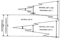
FIG. 10. -Comparison of geochronologic, chronostratigraphic, and diachronic units.
[Click on figure for enlarged view]
FIG. 11. -Schematic relation of phases to an episode.
Parts of a phase similarly may be divided into spans, and spans into clines. Formal definition of spans and clines is unnecessary in most diachronic unit hierarchies.
[Click on figure for enlarged view]
Ranks and Nomenclature of Diachronic Units
Article 93. -Ranks. A diachron is the fundamental and non-hierarchical diachronic unit. If a hierarchy of diachronic units is needed, the terms episode, phase, span, and cline, in order of decreasing rank, are recommended. The rank of a hierarchical unit is determined by the scope of the unit (Article 91b), and not by the time span represented by the unit at a particular place.
Remarks. (a) Diachron. -Diachrons may differ greatly in magnitude because they are the spans of time represented by individual or grouped lithostratigraphic, allostratigraphic, biostratigraphic, and(or) pedostratigraphic units.
(b) Hierarchical ordering permissible. -A hierarchy of diachronic units may be defined if the resolution of spatial and temporal relations of diachronous stratigraphic units is sufficiently precise to make the hierarchy useful (Watson and Wright, 1980). Although all hierarchical units of rank lower than episode are part of a unit next higher in rank, not all parts of an episode, phase, or span need be represented by a unit of lower rank.
(c) Episode. -An episode is the unit of highest rank and greatest scope in hierarchical classification. If the "Wisconsinan Age" were to be redefined as a diachronic unit, it would have the rank of episode.
Article 94. -Name. The name for a diachronic unit should be compound, consisting of a geographic name followed by the term diachron or a hierarchical rank term. Both parts of the compound name are capitalized to indicate formal status. If the diachronic unit is defined by a single stratigraphic unit, the geographic name of the unit may be applied to the diachronic unit. Otherwise, the geographic name of the diachronic unit should not duplicate that of another formal stratigraphic unit. Genetic terms (e.g., alluvial, marine) or climatic terms (e.g., glacial, interglacial) are not included in the names of diachronic units.
Remarks. (a) Formal designation of units. Diachronic units should be formally defined and named only if such definition is useful.
(b) Inter-regional extension of geographic names. -The geographic name of a diachronic unit may be extended from one region to another if the stratigraphic units on which the diachronic unit is based extend across the regions. If different diachronic units in contiguous regions eventually prove to be based on laterally continuous stratigraphic units, one name should be applied to the unit in both regions. If two names have been applied, one name should be abandoned and the other formally extended. Rules of priority (Article 7d) apply. Priority in publication is to be respected, but priority alone does not justify displacing a well-established name by one not well-known or commonly used.
(c) Change from geochronologic to diachronic classification. -Lithostratigraphic units have served as the material basis for widely accepted chronostratigraphic and geochronologic classifications of Quaternary nonmarine deposits, such as the classifications of Frye et al (1968), Willman and Frye (1970), and Dreimanis and Karrow (1972). In practice, time-parallel horizons have been extended from the stratotypes on the basis of markedly time-transgressive lithostratigraphic and pedostratigraphic unit boundaries. The time ("geochronologic") units, defined on the basis of the stratotype sections but extended on the basis of diachronous stratigraphic boundaries, are diachronic units. Geographic names established for such "geochronologic" units may be used in diachronic classification if (1) the chronostratigraphic and geochronologic classifications are formally abandoned and diachronic classifications are proposed to replace the former "geochronologic" classifications, and (2) the units are redefined as formal diachronic units. Preservation of well-established names in these specific circumstances retains the intent and purpose of the names and the units, retains the practical significance of the units, enhances communication, and avoids proliferation of nomenclature.
Article 95. -Establishing Formal Units. Requirements for establishing a formal diachronic unit, in addition to those in Article 3, include (1) specification of the nature, stratigraphic relations, and geographic or areal relations of the stratigraphic unit or units that serve as a basis for definition of the unit, and (2) specific designation and description of multiple reference sections that illustrate the temporal and spatial relations of the defining stratigraphic unit or units and the boundaries of the unit or units.
Remark. (a) Revision or abandonment. -Revision or abandonment of the stratigraphic unit or units that serve as the material basis for definition of a diachronic unit may require revision or abandonment of the diachronic unit. Procedure for revision must follow the requirements for establishing a new diachronic unit.
GEOCHRONOMETRIC UNITS
Nature and Boundaries
Article 96. -Definition. Geochronometric units are units established through the direct division of geologic time, expressed in years. Like geochronologic units (Article 80), geochronometric units are abstractions, i.e., they are not material units. Unlike geochronologic units, geochronometric units are not based on the time span of designated chronostratigraphic units (stratotypes), but are simply time divisions of convenient magnitude for the purpose for which they are established (e.g., Hofmann, 1990), such as the development of a time scale for the Precambrian. Their boundaries are arbitrarily chosen or agreed-upon ages in years.
Ranks and Nomenclature of Geochronometric Units
Article 97. -Nomenclature. Geochronologic rank terms (eon, era, period, epoch, age, and chron) may be used for geochronometric units when such terms are formalized. For example, Archean Eon and Proterozoic Eon, as recognized by the IUGS Subcommission on Precambrian Stratigraphy, are formal geochronometric units in the sense of Article 96, distinguished on the basis of an arbitrarily chosen boundary at 2.5 Ga. Geochronometric units are not defined by, but may have, corresponding chronostratigraphic units (eonothem, erathem, system, series, stage, and chronozone).
ACSN (American Commission on Stratigraphic Nomenclature), 1947, Note 1-Organization and objectives of the Stratigraphic Commission: American Association of Petroleum Geologists Bulletin, v. 31, no. 3, p. 513-518.
_____, 1961, Code of Stratigraphic Nomenclature: American Association of Petroleum Geologists Bulletin, v. 45, no. 5, p. 645-665.
_____, 1970, Code of Stratigraphic Nomenclature (2d ed.): American Association of Petroleum Geologists, Tulsa, Okla., 45 p.
_____, 1976, Note 44-Application for addition to code concerning magnetostratigraphic units: American Association of Petroleum Geologists Bulletin, v. 60, no. 2, p. 273-277.
Blatt, H., W.B.N. Berry, and S. Brande, 1990, Principles of stratigraphic analysis: Oxford, England, Blackwell Scientific Publications, 512 p.
Boggs, Sam, Jr., 2001, Principles of sedimentology and stratigraphy, 3rd edition: Upper Saddle River, New Jersey, Prentice Hall, 726 p.
Bujak, J.P., C. Downie, G.L. Eaton, and G.L. Williams, 1980, Dinoflagellate cyst zonation of the Eocene, southern England, in J.P. Bujak, C. Downie, G.L. Eaton, and G.L. Williams, Dinoflagellate crysts and acitarchs from the Eocene of southern England: Special Papers in Palaeontology 24, p. 15-26.
Caster, K. E., 1934, The stratigraphy and paleontology of northwestern Pennsylvania, Part 1, Stratigraphy: Bulletins of American Paleontology, v. 21, 185 p.
Chang, K. H., 1975, Unconformity-bounded stratigraphic units: Geological Society of America Bulletin, v. 86, no. 11, p. 1544-1552.
Committee on Stratigraphic Nomenclature, 1933, Classification and nomenclature of rock units: Geological Society of America Bulletin, v. 44, no. 2, p. 423-459, and American Association of Petroleum Geologists Bulletin, v. 17, no. 7, p. 843-868.
Cox, A. V., R. R. Doell, and G. B. Dalrymple, 1963, Geomagnetic polarity epochs and Pleistocene geochronometry: Nature, v. 198, p. 1049-1051.
_____, 1964, Reversals of the Earth's magnetic field: Science, v. 144, no. 3626, p. 1537-1543.
Cross, C. W., 1898, Geology of the Telluride area: U.S. Geological Survey l8th Annual Report, pt. 3, p. 759.
Cumming, A. D., J. G. C. M. Fuller, and J. W. Porter, 1959, Separation of strata: Paleozoic limestones of the Williston basin: American Journal of Science, v. 257, no. 10, p. 722-733.
Dreimanis, Aleksis, and P. F. Karrow, 1972, Glacial history of the Great Lakes-St. Lawrence region, the classification of the Wisconsin(an) Stage, and its correlatives: International Geologic Congress, 24th Session, Montreal, 1972, Section 12, Quaternary Geology, p. 5-15.
Dunbar, C . O., and John Rodgers, 1957, Principles of stratigraphy: Wiley, New York, 356 p.
Easton, R. M., 1992. The Grenville Province: In: Geology of Ontario, Chapter 19, Ontario Geol. Surv., Special Volume, Part 2, p. 713-904.
Easton, R.M., 1996a, Sequence Stratigraphic Terminology: The NACSN Perspective: Houston Geological Society Bulletin, v. 38, April 1996, p. 15-16.
Easton, R.M., 1996b, Law and Order in Stratigraphy: The Good,
The Bad and The New in the North American Stratigraphic Code:
Sudbury, Ontario, Program, Schedule and Abstracts, 30th Association
of Earth Science Editors Meeting, p. 14-15.
Easton, R.M., 2000, To every plutonic rock its proper stratigraphic
name: Blueline, v. 33, no. 2, p. 8-9.
Easton, R.M., D.L. Baars, and D.G. Cook, 1997, Note 62: Records
of Stratigraphic Commission, 1992-1994: American Association of
Petroleum Geologists Bulletin, v. 81, p. 1342-1345.
Easton, R.M., Edwards, L.E., and Wardlaw, B., 2003, Notes on geochronologic
and chronostratigraphic units: discussion: Geological Society
of America, Bulletin, v. 115, p. 1016-1019.
Edwards, L.E., and D.E. Owen, 1996, Note 61: Records of Stratigraphic
Commission, 1991-1992: American Association of Petroleum Geologists
Bulletin, v. 80, p. 1156-1159.
Ferrusquia-Villafranca, I., Easton, R.M., L.E. Edwards, R.H. Fakundiny, and J.O. Jones, 2001, Note 63: Application for Amendment of the North American Stratigraphic Code concerning consistency and updating regarding electronic publishing: American Association of Petroleum Geologists Bulletin, v.85, p. 366-375.
Forgotson, J. M., Jr., 1957, Nature, usage and definition of marker-defined vertically segregated rock units: American Association of Petroleum Geologists Bulletin, v. 41, no. 9, p. 2108-2113.
Frye, J. C., H. B. Willman, Meyer Rubin, and R. F. Black, 1968, Definition of Wisconsinan Stage: U.S. Geological Survey Bulletin 1274-E, 22 p.
George, T. N., and others, 1969, Recommendations on stratigraphical usage: Geological Society of London, Proceedings no. 1656, p. 139-166.
Harland, W. B., 1977, Essay review [of] International Stratigraphic Guide, 1976: Geology Magazine, v. 114, no. 3, p. 229-235.
_____, 1978, Geochronologic scales, in G. V. Cohee et al, eds., Contributions to the Geologic Time Scale: American Association of Petroleum Geologists, Studies in Geology, no. 6, p. 9-32.
Harrison, J. E., and Z. E. Peterman, 1980, North American Commission on Stratigraphic Nomenclature Note 52-A preliminary proposal for a chronometric time scale for the Precambrian of the United States and Mexico: Geological Society of America Bulletin, v. 91, no. 6, p. 377-380.
Henbest, L. G., 1952, Significance of evolutionary explosions for diastrophic division of Earth history: Journal of Paleontology, v. 26, p. 299-318.
Henderson, J. B., W. G. E. Caldwell, and J. E. Harrison, 1980, North American Commission on Stratigraphic Nomenclature, Report 8-Amendment of code concerning terminology for igneous and high-grade metamorphic rocks: Geological Society of America Bulletin, v. 91, no. 6, p. 374-376.
Hofmann, H.J., 1990, Precambrian time units and nomenclature -the geon concept: Geology, v. 18, p. 340-341.
Holland, C. H., and others, 1978, A guide to stratigraphical procedure: Geological Society of London, Special Report 10, p. 1-18.
Huxley, T. H., 1862, The anniversary address: Geological Society of London, Quarterly Journal, v. 18, p. xl-liv.
International Commission on Zoological Nomenclature, 1964: International Code of Zoological Nomenclature adopted by the XV International Congress of Zoology: International Trust for Zoological Nomenclature, London, 176 p.
ISSC (International Subcommission on Stratigraphic Classification), 1976, International Stratigraphic Guide (H. D. Hedberg, ed.): John Wiley and Sons, New York, 200 p.
_____, 1979, Magnetostratigraphy polarity units-a supplementary chapter of the ISSC International Stratigraphic Guide: Geology, v. 7, p. 578-583.
_____, Salvador, A., Edit., 1994. International Stratigraphic Guide: Trondheim, Norway & Boulder, Colo., The International Union of Geological Sciences and The Geological Society of America, Inc., 214 p.
Izett, G. A., and R. E. Wilcox, 1981, Map showing the distribution of the Huckleberry Ridge, Mesa Falls, and Lava Creek volcanic ash beds (Pearlette family ash beds) of Pliocene and Pleistocene age in the western United States and southern Canada: U.S. Geological Survey Miscellaneous Geological Investigations Map I-1325.
Klapper, G., and J.G. Johnson, 1980, Endemism and dispersal of Devonian conodonts: Journal of Paleontology, v. 54, p. 400-455.
Lenz, A.C., L.E. Edwards, and B.R. Pratt, 2001, Note 64: Application for revision of articles 48-54, biostratigraphic units, of the North American Stratigraphic Code: American Association of Petroleum Geologists Bulletin, v. 85, p. 372-375.
Matthews, R. K., 1974, Dynamic stratigraphy--an introduction to sedimentation and stratigraphy: Prentice-Hall, New Jersey, 370 p.
McDougall, Ian, 1977, The present status of the geomagnetic polarity time scale: Research School of Earth Sciences, Australian National University, Publication no. 1288, 34 p.
McElhinny, M. W., 1978, The magnetic polarity time scale; prospects and possibilities in magnetostratigraphy, in G. V. Cohee et al, eds., Contributions to the Geologic Time Scale, American Association of Petroleum Geologists, Studies in Geology, no. 6, p. 57-65.
McIver, N. L., 1972, Cenozoic and Mesozoic stratigraphy of the Nova Scotia shelf: Canadian Journal of Earth Science, v. 9, p. 54-70.
McLaren, D. J., 1977, The Silurian-Devonian Boundary Committee. A final report, in A. Martinsson, ed., The Silurian-Devonian boundary: IUGS Series A, no. 5, p. 1-34.
MERQ (Ministere de l'Energie et des Ressources du Quebec), 1986, Code stratigraphique Nord-Americain: DV 86-02, 58 p.
Morrison, R. B., 1967, Principles of Quaternary soil stratigraphy, in R. B. Morrison and H. E. Wright, Jr., eds., Quaternary soils: Reno, Nevada, Center for Water Resources Research, Desert Research Institute, Univ. Nevada, p. 1-69.
North American Commission on Stratigraphic Nomenclature (NACSN), 1981, Draft North American Stratigraphic Code: Canadian Society of Petroleum Geologists, Calgary, 63 p.
_____, 1983. North American Stratigraphic Code: American Assoc. Petrol. Geol. Bull., v. 67, p. 841-875.
Palmer, A. R., 1965, Biomere-a new kind of biostratigraphic unit: Journal of Paleontology, v. 39, no. l, p. 149-153.
Parsons, R. B., 1981, Proposed soil-stratigraphic guide, in International Union for Quaternary Research and International Society of Soil Science: INQUA Commission 6 and ISSS Commission 5 Working Group, Pedology, Report, p. 6-12.
Pawluk, S., 1978, The pedogenic profile in the stratigraphic section, in W. C. Mahaney, ed., Quaternary soils: Norwich, England, GeoAbstracts, Ltd., p. 61-75.
Ruhe, R. V., 1965, Quaternary paleopedology, in H. E. Wright, Jr., and D. G. Frey, eds., The Quaternary of the United States: Princeton, N.J., Princeton University Press, p. 755-764.
Schultz, E. H., 1982, The chronosome and supersome-terms proposed for low-rank chronostratigraphic units: Canadian Petroleum Geology, v. 30, no. 1, p. 29-33.
Shaw, A. B., 1964, Time in stratigraphy: McGraw-Hill, New York, 365 p.
Sims, P. K., 1979, Precambrian subdivided: Geotimes, v. 24, no. 12, p. 15.
Sloss, L. L., 1963, Sequences in the cratonic interior of North America: Geological Society of America Bulletin, v. 74, no. 2, p. 94-114.
Tracey, J. I., Jr., and others, 1971, Initial reports of the Deep Sea Drilling Project, v. 8: U.S. Government Printing Office, Washington, 1037 p.
Valentine, K. W. G., and J. B. Dalrymple, 1976, Quaternary buried paleosols: A critical review: Quaternary Research, v. 6, p. 209-222.
Watson, R. A., and H. E. Wright, Jr., 1980, The end of the Pleistocene: A general critique of chronostratigraphic classification: Boreas, v. 9, p. 153-163.
Weiss, M. P., 1979a, Comments and suggestions invited for revision of American Stratigraphic Code: Geological Society of America, News and Information, v. 1, no. 7, p. 97-99.
_____, 1979b, Stratigraphic Commission Note 50-Proposal to change name of Commission: American Association of Petroleum Geologists Bulletin, v. 63, no. 10, p. 1986.
Weller, J. M., 1960, Stratigraphic principles and practice: Harper and Brothers, New York, 725 p.
Willman, H. B., and J.C. Frye, 1970, Pleistocene stratigraphy of Illinois: Illinois State Geological Survey Bulletin 94, 204 p.
10 Readers are reminded of the extensive and noteworthy bibliography of contributions to stratigraphic princples, classification, and terminology cited by the International Stratigraphic Guide (ISSC, 1976, p. 111-187).
CONFEREES IN CODE REVISION
Code Committee
Steven S. Oriel (U.S. Geological Survey), chairman, Hubert Gabrielse (Geological Survey of Canada), William W. Hay (Joint Oceanographic Institutions), Frank E. Kottlowski (New Mexico Bureau of Mines), John B. Patton (Indiana Geological Survey).
Lithostratigrapbic Subcommittee
James D. Aitken (Geological Survey of Canada), chairman, Monti Lerand (Gulf Canada Resources, Ltd.), Mitchell W. Reynolds (U.S. Geological Survey), Robert J. Weimer (Colorado School of Mines), Malcolm P. Weiss (Northern Illinois University).
Biostratigraphic Subcommittee
Allison R. (Pete) Palmer (Geological Society of America), chairman, Ismael Ferrusquia (University of Mexico), Joseph E. Hazel (U.S. Geological Survey), Erle G. Kauffman (University of Colorado), Colin McGregor (Geological Survey of Canada), Michael A. Murphy (University of California, Riverside), Walter C. Sweet (Ohio State University).
Chronostratigraphic Subcommittee
Zell E. Peterman (U.S. Geological Survey), chairman, Zoltan de Cserna (Sociedad Geológica Mexicana), Edward H. Schultz (Suncor, Inc., Calgary), Norman F. Sohl (U.S. Geological Survey), John A. Van Couvering (American Museum of Natural History).
Plutonic-Metamorphic Advisory Group
Jack E. Harrison (U.S. Geological Survey), chairman, John B. Henderson (Geological Survey of Canada), Harold L. James (retired), Leon T. Silver (California Institute of Technology), Paul C. Bateman (U.S. Geological Survey).
Magnetostratigraphic Advisory Group
Roger W. Macqueen (University of Waterloo), chairman, G. Brent Dalrymple (U.S. Geological Survey), Walter F. Fahrig (Geological Survey of Canada), J. M. Hall (Dalhousie University).
Volcanic Advisory Group
Richard V. Fisher (University of California, Santa Barbara), chairman, Thomas A. Steven (U.S. Geological Survey), Donald A. Swanson (U.S. Geological Survey).
Tectonostratigraphic Advisory Group
Darrel S. Cowan (University of Washington), chairman, Thomas W. Donnelly (State University of New York at Binghamton), Michael W. Higgins and David L. Jones (U.S. Geological Survey), Harold Williams (Memorial University, Newfoundland).
Quaternary Advisory Group
Norman P. Lasca (University of Wisconsin-Milwaukee), chairman, Mark M. Fenton (Alberta Research Council), David S. Fullerton (U.S. Geological Survey), Robert J. Fulton (Geological Survey of Canada), W. Hilton Johnson (University of Illinois), Paul F. Karrow (University of Waterloo), Gerald M. Richmond (U.S. Geological Survey).
Conferees
W. G. E. Caldwell (University of Saskatchewan), Lucy E. Edwards (U.S. Geological Survey), Henry H. Gray (Indiana Geological Survey), Hollis D. Hedberg (Princeton University), Lewis H. King (Geological Survey of Canada), Rudolph W. Kopf (U.S. Geological Survey), Jerry A. Lineback (Robertson Research U.S.), Marjorie E. MacLachlan (U.S. Geological Survey), Amos Salvador (University of Texas, Austin), Brian R. Shaw (Samson Resources, Inc.), Ogden Tweto (U.S. Geological Survey).
APPENDIX II: 1977-2003 COMPOSITION OF THE NORTH AMERICAN COMMISSION ON STRATIGRAPHIC NOMENCLATURE
Each Commissioner is appointed, with few exceptions, to serve a 3-year term (shown by such numerals as 80-82 for 1980-1982) and a few are reappointed.
American Association of Petroleum Geologists
Timothy A. Anderson 77-83, Orlo E. Childs 76-79, Kenneth J. Englund 74-77, Susan Longacre 78-02, Donald E. Owen 79-85, 87-02, Grant Steele 75-78, Nahum Schneidermann 83-86, Robert R. Jordan 85-03.
Association of American State Geologists
Larry D. Fellows 81-82, 91-94, Lee C. Gerhard 79-81, Donald C. Haney 80-83, Wallace B. Howe 74-77, Robert R. Jordan 78-84, Frank E. Kottlowski 76-79, Meredith E. Ostrom 77-80, John B. Patton 75-78, Robert H. Fakundiny 81-92, 95-03, Ernest A. Mancini 83-86, 99-03, Gary B. Glass 84-87, Norman C. Hester 87, William T. Hill 86-89, Conrad Gazzier 88-90, Robert C. Milici 87-90, M. Lee Allison 88-91, Thomas M. Berg 90-94, John P. Bluemle 92-02, James Robertson 92-96, Norman Hester 97-02.
Geological Society of America
Clarence A. Hall, Jr. 78-81, Jack E. Harrison 74-77, William W. Hay 75-78, Robert S. Houston 77-80, Michael A. Murphy 81-84, Allison R. Palmer 80-83, Malcolm P. Weiss 76-82, Norman P. Lasca 82-85, Charles W. Copeland, Jr. 83-86, Patrick K. Sutherland 84-87, John M. Dennison 85-88, Robert F. Lundin 87-89, Donald E. Hattin, 88-90, Paul R. Seaber 89-92, Donald L. Baars 88-95, Peter R. Vail 90-94, Glenn B. Morey 91-94, Lee C. Gerhard 92-96, James O. Jones 92-97, Ardith K. Hansel 98-01, W. Burleigh Harris 95-98, David T. King 97-00, H. Richard Lane 02-03, Ernest A. Mancini 96-98, Walter L. Manger 02-03, Christopher G. Maples 01-03.
United States Geological Survey
Earl E. Brabb 78-82, David S. Fullerton 78-84, E. Dale Jackson 76-78, Kenneth L. Pierce 75-78, Norman F. Sohl 74-83, Joshua I. Tracey, Jr. 82-88, C. Wylie Poag 83-86, John H. Stewart 84-93, Lucy E Edwards 86-03, Forrest G. Poole 88-94, John Pojeta, Jr. 92-96, Mitchell W. Reynolds 92-95, Bruce R. Wardlaw 95-03, Randall C. Orndorff 97-03.
Geological Survey of Canada
James D. Aitken 75-78, Kenneth D. Card 80-83, Donald G. Cook 78-81, Robert J. Fulton 81-84, John B. Henderson 74-77, Lewis H. King 79-82, Maurice B. Lambert 77-80, Christopher J. Yorath 76-79, Ashton F. Embry, III 82-88, R.I. Thompson 83-86, Anthony Davidson 84-87, 97-02, Graham L. Williams 87-89, Fred W. Chandler 88-91, Michael P. Cecile 88-91, Lynda Dredge 90-94, John A. Percival 90-94, Donald G. Cook 92-94, Benoit Beauchamp 92-97, R.J. Fulton 92-96, Denis Lavoie 92-95, A.P. (Tony) Hamblin 98-03, Terry Poulton 99-01.
Canadian Society of Petroleum Geologists
Roland F. deCaen 79-85, J. Ross McWhae 77-80, Edward H. Schultz 74-77, 80-83, Ulrich Wissner -79, Timothy R. Marchant 83-86, C.E. Wright 85-89, Wayne Brideaux 87-88, Donald G. Cook 89-91, Raymond W. Yole 91-02, Brian Pratt 92-03.
Geological Association of Canada
W. G. E. Caldwell 76-79, R. K. Jull 78-79, Paul S. Karrow 81-84, Alfred C. Lenz 79-81, 85-88, 90-98, David E. Pearson 79-81, Paul E. Schenk 75-78, Grant D. Mossop 82-85, James T. Teller 84-87, John A. Westgate 87-90, R. Michael Easton 91-03, William R. Arnott 98-00.
Asociación Mexicana de Geólogos Petróleros
Jose Carillo Bravo 78-81, Baldomerro Carrasco-Velazquez, 75-78, 85-88, Carlos Manuel Cantu-Chapa 98-01.
Sociedad Geólogica Mexicana
Zoltan de Cserna 76-82, Jose Carrillo-Bravo 82-85, 96-01, Emiliano Campos-Madrigal 98-01.
Instituto de Geología de la Universidad Nacional Autónoma de México
Ismael Ferrusquia Villafranca 76-81, 92-03, Fernando Ortega Gutiérrez 81-90, Diego A. Cordoba-Mendez 90-92.
Commissioners-at-large
Jorge J. Aranda-Gomez 92-94, Donald E. Hattin 92-94, Norman P. Lasca 92-03, Diego A. Cordoba-Mendez 92-94, Paul R. Seaber 92-00.
APPENDIX III: REPORTS AND NOTES OF THE AMERICAN COMMISSION ON STRATIGRAPHIC NOMENCLATURE
Reports (formal declarations, opinions, and recommendations)
1. Moore, Raymond C., Declaration on naming of subsurface stratigraphic units: AAPG Bulletin, v. 33, no. 7, p. 1280-1282, 1949.
2. Hedberg, Hollis D., Nature, usage, and nomenclature of time-stratigraphic and geologic-time units: AAPG Bulletin, v. 36, no. 8, p. 1627-1638, 1952.
3. Harrison, J. M., Nature, usage, and nomenclature of time-stratigraphic and geologic-time units as applied to the Precambrian: AAPG Bulletin, v. 39, no. 9, p. 1859-1861, 1955.
4. Cohee, George V., and others, Nature, usage, and nomenclature of rock-stratigraphic units: AAPG Bulletin, v. 40, no. 8, p. 2003-2014, 1956.
5. McKee, Edwin D., Nature, usage and nomenclature of biostratigraphic units: AAPG Bulletin, v. 4l, no. 8, p. 1877-1889, 1957.
6. Richmond, Gerald M., Application of stratigraphic classification and nomenclature to the Quaternary: AAPG Bulletin, v. 43, no. 3, pt. I, p. 663-675, 1959.
7. Lohman, Kenneth E., Function and jurisdictional scope of the American Commission on Stratigraphic Nomenclature: AAPG Bulletin, v. 47, no. 5, p. 853-855, 1963.
8. Henderson, John B., W. G. E. Caldwell, and Jack E. Harrison, Amendment of code concerning terminology for igneous and high-grade metamorphic rocks: GSA Bulletin, pt. I, v. 91, no. 6, p. 374-376, 1980.
9. Harrison, Jack E., and Zell E. Peterman, Adoption of geochronometric units for divisions of Precambrian time: AAPG Bulletin, v. 66, no. 6, p. 801-802, 1982.
Notes (informal statements, discussions, and outlines of problems)
1. Organization and objectives of the Stratigraphic Commission: AAPG Bulletin, v. 31, no. 3, p. 513-518, 1947.
2. Nature and classes of stratigraphic units: AAPG Bulletin, v. 31, no. 3, p. 519-528, 1947.
3. Moore, Raymond C., Rules of geologic nomenclature of the Geological Survey of Canada: AAPG Bulletin, v. 32, no. 3, p. 366-367, 1948.
4. Jones, Wayne V., and Raymond C. Moore, Naming of subsurface stratigraphic units: AAPG Bulletin, v. 32, no. 3, p. 367-371, 1948.
5. Flint, Richard Foster, and Raymond C. Moore, Definition and adoption of the terms stage and age: AAPG Bulletin, v. 32, no. 3, p. 372-376, 1948.
6. Moore, Raymond C., Discussion of nature and classes of stratigraphic units: AAPG Bulletin, v. 32, no. 3, p. 376-381, 1948.
7. Records of the Stratigraphic Commission for 1947-1948: AAPG Bulletin, v. 33, no. 7, p. 1271-1273, 1949.
8. Australian Code of Stratigraphical Nomenclature: AAPG Bulletin, v. 33, no. 7, p. 1273-1276, 1949.
9. The Pliocene-Pleistocene boundary: AAPG Bulletin, v. 33, no. 7, p. 1276-1280, 1949.
10. Moore, Raymond C., Should additional categories of stratigraphic units be recognized?: AAPG Bulletin, v. 34, no. 12, p. 2360-2361, 1950.
11. Moore, Raymond C., Records of the Stratigraphic Commission for 1949-1950: AAPG Bulletin, v. 35, no. 5, p. 1074-1076, 1951.
12. Moore, Raymond C., Divisions of rocks and time: AAPG Bulletin, v. 35, no. 5, p. 1076, 1951.
13. Williams, James Steele, and Aureal T. Cross, Third Congress of Carboniferous Stratigraphy and Geology: AAPG Bulletin, v. 36, no. 1, p. 169-172, 1952.
14. Official report of round table conference on stratigraphic nomenclature at Third Congress of Carboniferous Stratigraphy and Geology, Heerlen, Netherlands, June 26-28, 1951: AAPG Bulletin, v. 36, no. 10, p. 2044-2048, 1952.
15. Records of the Stratigraphic Commission for 1951-1952: AAPG Bulletin, v. 37, no. 5, p. 1078-1080, 1953.
16. Records of the Stratigraphic Commission for 1953-1954: AAPG Bulletin, v. 39, no. 9, p. 1861-1863, 1955.
17. Suppression of homonymous and obsolete stratigraphic names: AAPG Bulletin, v. 40, no. 12, p. 2953-2954, 1956.
18. Gilluly, James, Records of the Stratigraphic Commission for 1955-1956: AAPG Bulletin, v. 41, no. 1, p. 130-133, 1957.
19. Richmond, Gerald M., and John C. Frye, Status of soils in stratigraphic nomenclature: AAPG Bulletin, v. 31, no. 4, p. 758-763, 1957.
20. Frye, John C., and Gerald M. Richmond, Problems in applying standard stratigraphic practice in nonmarine Quaternary deposits: AAPG Bulletin, v. 42, no. 8, p. 1979-1983, 1958.
21. Frye, John C., Preparation of new stratigraphic code by American Commission on Stratigraphic Nomenclature: AAPG Bulletin, v. 42, no. 8, p. 1984-1986, 1958.
22. Records of the Stratigraphic Commission for 1957-1958: AAPG Bulletin, v. 43, no. 8, p. 1967-1971, 1959.
23. Rodgers, John, and Richard B. McConnell, Need for rock-stratigraphic units larger than group: AAPG Bulletin, v. 43, no. 8, p. 1971-1975, 1959.
24. Wheeler, Harry E., Unconformity-bounded units in stratigraphy: AAPG Bulletin, v. 43, no. 8, p. 1975-1977, 1959.
25. Bell, W. Charles, and others, Geochronologic and chronostratigraphic units: AAPG Bulletin, v. 45, no. 5, p. 666-670, 1961.
26. Records of the Stratigraphic Commission for 1959-1960: AAPG Bulletin, v. 45, no. 5, p. 670-673, 1961.
27. Frye, John C., and H. B. Willman, Morphostratigraphic units in Pleistocene stratigraphy: AAPG Bulletin, v. 46, no. 1, p. 112-113, 1962.
28. Shaver, Robert H., Application to American Commission on Stratigraphic Nomenclature for an amendment of Article 4f of the Code of Stratigraphic Nomenclature on informal status of named aquifers, oil sands, coal beds, and quarry layers: AAPG Bulletin, v. 46, no. 10, p. 1935, 1962.
29. Patton, John B., Records of the Stratigraphic Commission for 1961-1962: AAPG Bulletin, v. 47, no. 11, p. 1987-1991, 1963.
30. Richmond, Gerald M., and John G. Fyles, Application to American Commission on Stratigraphic Nomenclature for an amendment of Article 31, Remark (b) of the Code of Stratigraphic Nomenclature on misuse of the term "stage": AAPG Bulletin, v. 48, no. 5, p. 710-711, 1964.
31. Cohee, George V., Records of the Stratigraphic Commission for 1963-1964: AAPG Bulletin, v. 49, no. 3, pt. I of II, p. 296-300, 1965.
32. International Subcommission on Stratigraphic Terminology, Hollis D. Hedberg, ed., Definition of geologic systems: AAPG Bulletin, v. 49, no. 10, p. 1694-1703, 1965.
33. Hedberg, Hollis D., Application to American Commission on Stratigraphic Nomenclature for amendments to Articles 29, 31, and 37 to provide for recognition of erathem, substage, and chronozone as time-stratigraphic terms in the Code of Stratigraphic Nomenclature: AAPG Bulletin, v. 50, no. 3, p. 560-561, 1966.
34. Harker, Peter, Records of the Stratigraphic Commission for 1964-1966: AAPG Bulletin, v. 51, no. 9, p. 1862-1868, 1967.
35. DeFord, Ronald K., John A. Wilson, and Frederick M. Swain, Application to American Commission on Stratigraphic Nomenclature for an amendment of Article 3 and Article 13, Remarks (c) and (e), of the Code of Stratigraphic Nomenclature to disallow recognition of new stratigraphic names that appear only in abstracts, guidebooks, microfilms, newspapers, or in commercial or trade journals: AAPG Bulletin, v. 51, no. 9, p. 1868-1869, 1967.
36. Cohee, George V., Ronald K. DeFord, and H. B. Willman, Amendment of Article 5, Remarks (a) and (e) of the Code of Stratigraphic Nomenclature for treatment of geologic names in a gradational or interfingering relationship of rock-stratigraphic units: AAPG Bulletin, v. 53, no. 9, p. 2005-2006, 1969.
37. Kottlowski, Frank E., Records of the Stratigraphic Commission for 1966-1968: AAPG Bulletin, v. 53, no. 10, p. 2179-2186, 1969.
38. Andrews, J., and K. Jinghwa Hsü, A recommendation to the American Commission on Stratigraphic Nomenclature concerning nomenclatural problems of submarine formations: AAPG Bulletin, v. 54, no. 9, p. 1746-1747, 1970.
39. Wilson, John Andrew, Records of the Stratigraphic Commission for 1968-1970: AAPG Bulletin, v. 55, no. 10, p. 1866-1872, 1971.
40. James, Harold L., Subdivision of Precambrian: An interim scheme to be used by U.S. Geological Survey: AAPG Bulletin, v. 56, no. 6, p. 1128-1133, 1972.
41. Oriel, Steven S., Application for amendment of Article 8 of code, concerning smallest formal rock-stratigraphic unit: AAPG Bulletin, v. 59, no. 1, p. 134-135, 1975.
42. Oriel, Steven S., Records of Stratigraphic Commission for 1970-1972: AAPG Bulletin, v. 59, no. 1, p. 135-139, 1975.
43. Oriel, Steven S., and Virgil E. Barnes, Records of Stratigraphic Commission for 1972-1974: AAPG Bulletin, v. 59, no. 10, p. 2031-2036, 1975.
44. Oriel, Steven S., Roger W. Macqueen, John A. Wilson, and G. Brent Dalrymple, Application for addition to code concerning magnetostratigraphic units: AAPG Bulletin, v. 60, no. 2, p. 273-277, 1976.
45. Sohl, Norman F., Application for amendment concerning terminology for igneous and high-grade metamorphic rocks: AAPG Bulletin, v. 61, no. 2, p. 248-251, 1977.
46. Sohl, Norman F., Application for amendment of Articles 8 and 10 of code, concerning smallest formal rock-stratigraphic unit: AAPG Bulletin, v. 61, no. 2, p. 252, 1977.
47. Macqueen, Roger W., and Steven S. Oriel, Application for amendment of Articles 27 and 34 of stratigraphic code to introduce point-boundary stratotype concept: AAPG Bulletin, v. 61, no. 7, p. 1083-1085, 1977.
48. Sohl, Norman F., Application for amendment of Code of Stratigraphic Nomenclature to provide guidelines concerning formal terminology for oceanic rocks: AAPG Bulletin, v. 62, no. 7, p. 1185-1186, 1978.
49. Caldwell, W.G.E.., and N. F. Sohl, Records of Stratigraphic Commission for 1974-1976: AAPG Bulletin, v. 62, no. 7, p. 1187-1192, 1978.
50. Weiss, Malcolm P., Proposal to change name of commission: AAPG Bulletin, v. 63, no. 10, p. 1986, 1979.
51. Weiss, Malcolm P., and James D. Aitken, Records of Stratigraphic Commission, 1976-1978: AAPG Bulletin, v. 64, no. 1, p. 136-137, 1980.
52. Harrison, Jack E., and Zell E. Peterman, A preliminary proposal for a chronometric time scale for the Precambrian of the United States and Mexico: GSA Bulletin, pt. I, v. 91, no. 6, p. 377-380, 1980.
53. Salvador, Amos. (Editor). 1994. International Stratigraphic Guide. Second Edition. International Union of Geological Sciences and Geological Society of America.
54. George, T.N. et al. 1969. Recommendations on stratigraphical usage. Proceedings of the Geological Society of London, no. 1656, p. 139-166.
55. Klapper, G., and Johnson, J.G. 1980. Endemism and dispersal of Devonian conodonts: Journal of Paleontology, v. 54, p. 400-455.
56. Bujak, J.P., Downie, C., Eaton, G.L., and Williams, G.L., 1980, Dinoflagellate cyst zonation of the Eocene, southern England, in Bujak, J.P., Downie, C., Eaton, G.L., and Williams, G.L., Dinoflagellate cysts and acritarch from the Eocene of southern England: Special Papers in Palaeontology, no. 24, p. 15-26.
57. Fakundiny, Robert H., and Susan A. Longacre, Application for amendment of North American Stratigraphic Code to provide for exclusive informal use of morphological terms such as Batholith, Intrusion, Pluton, Stock, Plug, Dike, Sill, Diapir, and Body: AAPG Bulletin, v. 73, no. 11, p. 1452-1453, 1989.
58. Fakundiny, Robert H. and Robert F. Lundin, Records of Stratigraphic
Commission, 1986-1988: AAPG Bulletin, v. 75, no. 7, p. 1275-1278,
1991.
59. Chandler, Fred W. and Robert R. Jordan, Records of Stratigraphic
Commission, 1988-1990: AAPG Bulletin, v. 76, no. 12, p. 1933-1934,
1992.
60: Edwards, Lucy E. Application for amendment of North American
Stratigraphic Code to clarify relation of allostratigraphic and
lithostratigraphic units: AAPG Bulletin, v. 77, no. 5, p. 909-943,
1993.
61. Edwards, Lucy E., and Donald E. Owen, Records of Stratigraphic
Commission, 1991-1992: AAPG Bulletin, v. 80, no. 7, p. 1156-1159,
1996.
62. Easton, R. Michael, Donald L. Baars, and Donald G. Cook, Records
of Stratigraphic Commission, 1992-1994: AAPG Bulletin, v. 81,
no. 8, p. 1342-1345, 1997.
63. Ferrusquia-Villafranca, Ismael, Easton, R. Michael, Edwards,
Lucy E., Fakundiny, Robert H. and Jones, James O., Application
for amendment of the North American Stratigraphic Code concerning
consistency and updating regarding electronic publishing: AAPG
Bulletin, v. 85, no. 2, p. 366-371, 2001.
64. Lenz, Alfred C., Edwards, Lucy E., and Pratt, Brian R., Application
for revision of articles 48-54, biostratigraphic units, of the
North American Stratigraphic Code: AAPG Bulletin, v. 85, no. 2,
p. 372-375, 2001.
65. Easton, R. Michael, James O. Jones, Alfred
C. Lenz, Ismael Ferrusquia-Villafranca, Ernest A. Mancini, Bruce
R. Wardlaw, Lucy E. Edwards, and Brian Pratt, Records of Stratigraphic
Commission, 1995-2002: AAPG Bulletin, v. 89, p. 1459-1464, 2005.
This web site is maintained by Randall C. Orndorff
U.S. Geological Survey
MS 926A National Center
Reston, Virginia 20192
U.S.A.
[email protected]
This page updated April 7, 2006.