- Usage in publication:
-
- Zeeland Drift
- Modifications:
-
- Named
- Dominant lithology:
-
- Till
- AAPG geologic province:
-
- Williston basin
Summary:
Pg. 62. Defined as morphostratigraphic unit consisting of till of Zeeland end moraine plus till of associated ground moraine and all other associated drift originating from same glacial ice. Occurs in Zeeland subdistrict and southern edge of Wishek subdistrict in McIntosh County. Thickness not given. Distinguished from older Napoleon Drift (new) by light olive-gray till and a drainage system that is only partly integrated; separated from younger Burnstad Drift (new) by Venturia end moraine which overlaps Zeeland moraine and probably represents a readvance. Assigned late Wisconsin (Pleistocene) age based on correlation of Zeeland equivalent in South Dakota with Mankato drift in Minnesota and Iowa which has in part been dated at 11,700 yr. Report includes geologic map, correlation chart. Drifts described in this report are not lithostratigraphic units as defined by American Commission on Stratigraphic Nomenclature (ACSN, 1961) because drifts have been differentiated by their topographic form, geographic position, and inferred geologic history.
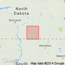
Type area: secs. 11, 12, 13, 14, 23, and 24, T. 130 N., R. 73 W., 6 mi northeast of Zeeland, McIntosh Co., ND (Williston basin). Named for town of Zeeland in southwest McIntosh Co., ND.
Source: GNU records (USGS DDS-6; Denver GNULEX); US geologic names lexicon (USGS Bull. 1350, p. 845).
For more information, please contact Nancy Stamm, Geologic Names Committee Secretary.
Asterisk (*) indicates published by U.S. Geological Survey authors.
"No current usage" (†) implies that a name has been abandoned or has fallen into disuse. Former usage and, if known, replacement name given in parentheses ( ).
Slash (/) indicates name conflicts with nomenclatural guidelines (CSN, 1933; ACSN, 1961, 1970; NACSN, 1983, 2005, 2021). May be explained within brackets ([ ]).

