


- Usage in publication:
-
- Zebulon Formation*
- Modifications:
-
- Named
- Dominant lithology:
-
- Schist
- Amphibolite
- Gneiss
- AAPG geologic province:
-
- Piedmont-Blue Ridge province
Summary:
The Zebulon Formation in the Zebulon thrust sheet in GA and AL is named for outcrops near Zebulon, Pike Co., GA. It includes the Senoia Member, reduced from the Senoia Formation of Higgins and Atkins (1981), and the schist-amphibolite-gneiss unit removed from the here revised Richard Russell Gneiss. It is an assemblage of intercalated schists, amphibolites, and lesser amounts of gneiss. Locally it is melange with blocks of amphibolite and ultramafic rocks in schist. Some of the rocks of the Zebulon were erroneously assigned by McConnell and Abrams (1984) to the Univeter Formation, here abandoned. Thickness is >3,000 m. Age is Late Proterozoic to Early Ordovician(?).
Source: GNU records (USGS DDS-6; Reston GNULEX).
- Usage in publication:
-
- Zebulon Formation
- Modifications:
-
- Not used
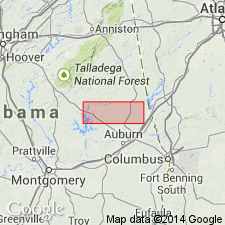
- Areal extent
- AAPG geologic province:
-
- Piedmont-Blue Ridge province
Summary:
Authors recognize that rocks previously assigned to Zebulon Formation in Chambers Co., AL, (Sears and others, 1981) are very similar to those of Ropes Creek and choose not to use Zebulon, but assign rocks in question to Ropes Creek.
Source: GNU records (USGS DDS-6; Reston GNULEX).
For more information, please contact Nancy Stamm, Geologic Names Committee Secretary.
Asterisk (*) indicates published by U.S. Geological Survey authors.
"No current usage" (†) implies that a name has been abandoned or has fallen into disuse. Former usage and, if known, replacement name given in parentheses ( ).
Slash (/) indicates name conflicts with nomenclatural guidelines (CSN, 1933; ACSN, 1961, 1970; NACSN, 1983, 2005, 2021). May be explained within brackets ([ ]).