The National Geologic Map Database is migrating to a new infrastructure. We apologize for any service disruptions during this process.
|
|---|


- Usage in publication:
-
- Zama member
- Modifications:
-
- Named
- Dominant lithology:
-
- Clay
- Silt
- Sand
- AAPG geologic province:
-
- Mid-Gulf Coast basin
Summary:
Pg. 20 (fig. 6), 31-35, 38 (fig. 14). Zama member named and assigned to base of Zilpha formation. Consists chiefly of relatively sand- and silt-free clay, glauconite, glauconitic silt, glauconitic sandy clay, glauconitic clayey sand, and concretionary siderite. Includes all strata in Zilpha formation above top of Winona formation and below top of a prominent glauconite bed that defines top of formation. Thickness 30 feet. Age is Eocene.
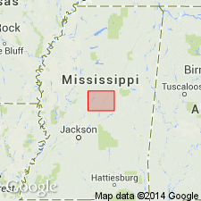
Type section: exposed in cuts of State Highway 19 at top of hill, in SE/4 NW/4 sec. 22, T. 13 N., R. 9 E., about 1 mile southeast of intersection of the road west of Zama, Attala Co., central MS.
Source: US geologic names lexicon (USGS Bull. 1350, p. 844); GNU records (USGS DDS-6; Reston GNULEX).
For more information, please contact Nancy Stamm, Geologic Names Committee Secretary.
Asterisk (*) indicates published by U.S. Geological Survey authors.
"No current usage" (†) implies that a name has been abandoned or has fallen into disuse. Former usage and, if known, replacement name given in parentheses ( ).
Slash (/) indicates name conflicts with nomenclatural guidelines (CSN, 1933; ACSN, 1961, 1970; NACSN, 1983, 2005, 2021). May be explained within brackets ([ ]).