

- Usage in publication:
-
- Yale Point sandstone*
- Modifications:
-
- Named
- Dominant lithology:
-
- Sandstone
- AAPG geologic province:
-
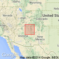
- Black Mesa basin
Summary:
Name proposed for the upper formation of the Upper Cretaceous Mesaverde group. Forms the massive sandstone cliff that caps Black Mesa, Arizona. Is yellow-gray, coarse- to medium-grained, subround to subangular clear quartz sandstone with fair sorting and large amounts of altered feldspar and mica as accessory minerals. Bedding varies from lenticular trough-type crossbeds to medium-scale crossbeds. Has some thin silty beds and minor amounts of coal. Is 204 feet thick at type with a maximum of 300 feet known at north end of Marsh Pass. Thins to south because of intertonguing with underlying Wepo formation of Mesaverde group. Is only 50 feet thick at Wepo Wash. Has fossils of middle Niobrara age. Is considered to be of marine origin. Is correlative with Hosta tongue of Point Lookout sandstone and upper part of Straight Cliffs sandstone.
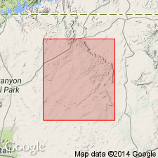
Type section measured 0.75 mi west of Yale Point, Black Mesa, AZ, in the Black Mesa basin.
Source: GNU records (USGS DDS-6; Denver GNULEX).
- Usage in publication:
-
- Yale Point Sandstone*
- Modifications:
-
- Biostratigraphic dating
- Mapped 1:500k
- Dominant lithology:
-
- Sandstone
- AAPG geologic province:
-
- Black Mesa basin
Summary:
Is Upper Cretaceous formation mapped along northeast edge of Black Mesa in Navajo and Apache Counties, Arizona (Black Mesa basin). Is a massive sandstone that forms nearly continuous vertical escarpment above Wepo Formation (Upper Cretaceous). Crops out in only a small area, its width generally no more than 6 miles. Intertongues with the partly equivalent, partly underlying Wepo. No younger rocks overlie the Yale Point, and its upper limit is the surface of recent erosion. Is yellowish gray (5Y 8/1), weathers grayish orange (10YR 7/4), and is composed of coarse- to fine-grained subrounded to subangular clear quartz; is fairly well sorted and contains large amounts of altered feldspar and mica as accessory minerals; bedding is lenticular, and individual units are cross-bedded; cross-bedding is of trough type, with medium-scale crossbeds deposited at medium to low angles; locally contains thin silty units that are not apparent in cliff faces, but which permit the formation to weather into a series of ledges and minor slopes on less precipitous exposures; southward, intertonguing with Wepo introduces finer grained units and locally minor amounts of coal. Is 204 feet thick at type; maximum thickness about 380 feet near Chilchinbito; from whence southward, the unit rapidly thins due to intertonguing with Wepo. Reeside and Barker (1929) listed fossils collected by H. E. Gregory, apparently from the Yale Point, that include INOCERAMUS STANTONI and considered typical of the middle of the Niobrara. The zonal index N-3 SCAPHITES DEPRESSUS is recorded (fig. 7), [which Cobban and Reeside (1952) assigned as the upper zone of the Coniacian Stage.]
Source: GNU records (USGS DDS-6; Denver GNULEX).
For more information, please contact Nancy Stamm, Geologic Names Committee Secretary.
Asterisk (*) indicates published by U.S. Geological Survey authors.
"No current usage" (†) implies that a name has been abandoned or has fallen into disuse. Former usage and, if known, replacement name given in parentheses ( ).
Slash (/) indicates name conflicts with nomenclatural guidelines (CSN, 1933; ACSN, 1961, 1970; NACSN, 1983, 2005, 2021). May be explained within brackets ([ ]).