The National Geologic Map Database is migrating to a new infrastructure. We apologize for any service disruptions during this process.
|
|---|


- Usage in publication:
-
- Woodside shale*
- Modifications:
-
- Original reference
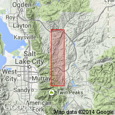
- Dominant lithology:
-
- Shale
- AAPG geologic province:
-
- Uinta uplift
Summary:
Pg. 439-458. Woodside shale. A lithologic unit composed, from bottom to top, without significant exception, of fine-grained thinly bedded dark-red shale. Bears ripple marks, mud cracks, and raindrop imprints. Thickness 1,180 feet in Park City district, Utah, where it underlies Thaynes limestone and overlies Park City formation. [Recognized in northeastern Utah, southwestern Wyoming, and southeastern Idaho. Age is Early Triassic.]
Named from Woodside Gulch, Park City mining district, the best exposure being at head of this gulch, on slope that overlooks the Silver King plant from west.
Source: US geologic names lexicon (USGS Bull. 896, p. 2369).
- Usage in publication:
-
- Woodside shale*
- Modifications:
-
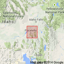
- Overview
- Areal extent
- AAPG geologic province:
-
- Snake River basin
Summary:
This Lower Triassic formation mapped in the Park City District of UT (geologic map) is also mapped in Bannock and Bingham Cos., ID in the Snake River basin. It overlies Phosphoria formation and underlies Ross Fork limestone, basal formation of the Thaynes group. Ross Fork of this report was designated Ross limestone in earlier reports. The basal contact placed in a zone of brown-yellow shales and limestones not easily distinguished from the underlying Phosphoria. Its top is marked by base of MEEKOCERAS zone of the Ross Fork. Woodside is about 900 ft thick in area and mostly yellow and drab, platy, calcareous and sandy shale with a few gray dense limestone beds. Some of the limestones are crowded with the pelecypod MYALINA. The red-brown color attributed to the Woodside in UT is not a characteristic of the formation in southeast ID. Forms smooth slopes (shale) and ledges (limestone). Assigned to Lower Triassic. Stratigraphic table. History of nomenclature chart.
Source: GNU records (USGS DDS-6; Denver GNULEX).
- Usage in publication:
-
- Woodside shale
- Modifications:
-
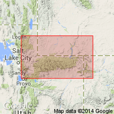
- Revised
- Areal extent
- AAPG geologic province:
-
- Uinta basin
Summary:
Lower part of Triassic sequence is divisible between Fort Douglas, Salt Lake Co, UT on the Wasatch uplift, and Whiterocks Canyon, Duchesne Co, UT in the Uinta basin, where the Thaynes limestone is present. East of Whiterocks Canyon to Skull Creek in Uintah Co, UT in the Uinta basin, the name Woodside shale is applied to the undivided Triassic section above Park City formation, or locally the Weber sandstone, and below Gartra grit member (new name) of Stanaker formation (new name). Upper contact considered revised because it underlies newly named units.
Source: GNU records (USGS DDS-6; Denver GNULEX).
- Usage in publication:
-
- Woodside redbeds*
- Modifications:
-
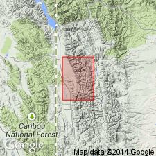
- Overview
- AAPG geologic province:
-
- Green River basin
Summary:
Name applied to some nonresistant red siltstones and shales above the Dinwoody formation and below the Thaynes limestone. Includes a few thin beds of red sandstone and gray shale. Ranges between 500 and 700 ft thick. Unlike all other formations in the area, the Woodside thickens eastward. Mapped (geologic map) in the central-south part of the quad. in Lincoln Co., WY in the Greater Green River basin. Assigned to the Lower Triassic.
Source: GNU records (USGS DDS-6; Denver GNULEX).
For more information, please contact Nancy Stamm, Geologic Names Committee Secretary.
Asterisk (*) indicates published by U.S. Geological Survey authors.
"No current usage" (†) implies that a name has been abandoned or has fallen into disuse. Former usage and, if known, replacement name given in parentheses ( ).
Slash (/) indicates name conflicts with nomenclatural guidelines (CSN, 1933; ACSN, 1961, 1970; NACSN, 1983, 2005, 2021). May be explained within brackets ([ ]).