

- Usage in publication:
-
- Woodchopper volcanics*
- Modifications:
-
- Named
- Biostratigraphic dating
- Dominant lithology:
-
- Greenstone
- Volcanics
- Limestone
- AAPG geologic province:
-
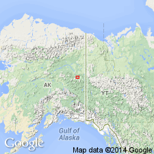
- Alaska East-Central region
Summary:
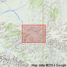
Named for outcrops along both banks of Yukon River from mouth of Coal Creek, Woodchopper Creek on downstream for 15 mi extending on south bank just beyond mouth of Thanksgiving Creek, Eagle-Circle district, east-central AK. Section described on south bank of Yukon River below Coal Creek. Consists of basaltic greenstone interbedded with minor amounts of limestone, slate, and chert. Is complexly folded and faulted. Thickness is about 7700 ft. Contains late Middle Devonian fossils (17 collections listed).
Source: GNU records (USGS DDS-6; Menlo GNULEX).
- Usage in publication:
-
- Woodchopper Volcanics*
- Modifications:
-
- Age modified
- Biostratigraphic dating
- AAPG geologic province:
-
- Alaska East-Central region
Summary:
Shale bed near type locality [evidently outcrops on Woodchopper Creek as described by Mertie (1930)] contains Early Devonian graptolites. Age of unit previously considered to be of Early(?) and Middle Devonian age, is here considered to be Early, Middle(?), and Late(?) Devonian age based on graptolites and corals.
Source: GNU records (USGS DDS-6; Menlo GNULEX).
For more information, please contact Nancy Stamm, Geologic Names Committee Secretary.
Asterisk (*) indicates published by U.S. Geological Survey authors.
"No current usage" (†) implies that a name has been abandoned or has fallen into disuse. Former usage and, if known, replacement name given in parentheses ( ).
Slash (/) indicates name conflicts with nomenclatural guidelines (CSN, 1933; ACSN, 1961, 1970; NACSN, 1983, 2005, 2021). May be explained within brackets ([ ]).