The National Geologic Map Database is migrating to a new infrastructure. We apologize for any service disruptions during this process.
|
|---|


- Usage in publication:
-
- Wiota gravels*
- Modifications:
-
- Adopted
- Dominant lithology:
-
- Gravel
- Sand
- AAPG geologic province:
-
- Williston basin
Summary:
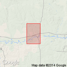
Wiota gravels. Name applied by Jensen (1951, USGS Open-File Rpt. [51-37], 37 p.) in area 25 miles to west, in Frazer 15-min quadrangle, to preglacial gravels deposited later than Flaxville gravel. Consist of well-rounded fragments of very fine- to medium-grained quartzite. Large part of unit is sand; lenses of silt and clay are present locally. Vary laterally from deposits that consist entirely of sand to those that contain coarse gravel. Commonly reddish brown. Thickness 1 to 30 feet; commonly 10 to 15 feet; at Wolf Point 26 feet. Till-covered terrace remnants, consisting of Wiota gravels, crop out in many places and can be grouped on basis of surface altitudes, between 2,550 feet (oldest) and 2,060 feet elevation. Overlie rocks ranging in age from Upper Cretaceous to Miocene or Pliocene. In vicinity of Wolf Point, overlie Bearpaw shale, Fox Hills, Hell Creek, and Fort Union formations, and Flaxville gravel. Capped by till as much as 20 feet thick. [Fossils. Age is Pleistocene (Wisconsin).]
[Wiota Station (no longer exists) on the Great Northern Railway at junction of U.S. Government's spur line to Fort Peck, in NE/4 sec. 14, T. 27 N., R. 42 E., Nashua 15-min quadrangle (1916 ed.), Valley Co., northwestern MT (see Jensen and Varnes, USGS Prof. Paper 414-F, p. F28).]
Source: US geologic names lexicon (USGS Bull. 1200, p. 4270).
- Usage in publication:
-
- Wiota gravels*
- Modifications:
-
- [Reference]
- AAPG geologic province:
-
- Williston basin
Summary:
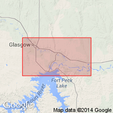
F28-F31. Wiota gravels. These gravels were deposited by streams and rivers on a number of levels ranging from about 200 feet to more than 500 feet below the gravel plain of the Flaxville formation. It is the consensus of the workers that the gravels on these several benches and terraces in eastern Montana cannot be properly subdivided at the present time and that one formational name should be used to refer to them all. Consists of a reddish brown sandy quartzite gravel and fine to medium sand, and a heterogenous facies ranging from tan sandy silt to poorly sorted reddish-brown fine gravel. Exposures are discontinuous but widespread in Valley, Roosevelt, and Sheridan Cos., northeastern MT. In most places observed thickness 6 to 20 feet; maximum thickness about 30 feet in vicinity of Wiota. In Fort Peck area, overlie Bearpaw shale and underlie ground moraine sediments. Fossils (vertebrates). Age is Pleistocene (pre-Wisconsin). Origin of name stated.
Named from Wiota Station [no longer exists] on the Great Northern Railway at junction of U.S. Government's spur line to Fort Peck, [in NE/4 sec. 14, T. 27 N., R. 42 E., Nashua 15-min quadrangle (1916 ed.), Valley Co., northeastern MT].
Described and measured sections exhibiting typical Wiota, [reference sections]:
(1) north wall of tributary to Porcupine Creek, in NE/4 NE/4 sec. 29, T. 29 N., R. 41 E., [Lindeke Coulee 7.5-min quadrangle, Valley Co.], 30+ feet thick;
(2) highway cut near upland level, in northern corner sec. 29, T. 28 N., R. 42 E., [Nashua 7.5-min quadrangle, Valley Co.], 22 feet thick;
(3) roadcut of road leading from U.S. Highway 2 north to gravel pit, in SW/4 sec. 36, T. 28 N., R. 41 E., [southeastern corner of Lindeke Coulee 7.5-min quadrangle, Valley Co.], 12 feet thick;
(4) gravel pit, in center N/2 sec. 10, T. 27 N., R. 41 E., [Fort Peck 7.5-min quadrangle, Valley Co.], 15 to 16 feet thick; and
(5) cutbank on north bank of Missouri River, in SE/4 sec. 6, T. 26 N., R. 44 E., [Frazer 7.5-min quadrangle, Valley Co.], 22 feet thick.
Source: Publication.
For more information, please contact Nancy Stamm, Geologic Names Committee Secretary.
Asterisk (*) indicates published by U.S. Geological Survey authors.
"No current usage" (†) implies that a name has been abandoned or has fallen into disuse. Former usage and, if known, replacement name given in parentheses ( ).
Slash (/) indicates name conflicts with nomenclatural guidelines (CSN, 1933; ACSN, 1961, 1970; NACSN, 1983, 2005, 2021). May be explained within brackets ([ ]).