

- Usage in publication:
-
- Winnipegosis formation
- Modifications:
-
- Revised
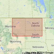
- AAPG geologic province:
-
- Williston basin
Summary:
Newly assigned to the Elk Point group (rank raised) as one of four formations. Overlies Elm Point formation of Elk Point. Underlies Prairie evaporite formation (new) of Elk Point. Shown on cross section as present in MB, CN in the Williston basin on the outcrop along the shores of Lake Winnipegosis and Manitoba. Also present in adjacent subsurface (well-log descriptions). Noted for its bioherms. Some of the outcrops are masses of colonial-corals; others have fragmental fossils cemented with algal material. Inter-reef beds are yellow-gray, medium saccharoidal, poorly fossiliferous dolostone. Field evidence suggests these beds are dropped over buried reefs of large size. Thickness varies according to position near a reef; is more than 400 ft thick. Middle Devonian age. Correlation chart; cross sections.
Source: GNU records (USGS DDS-6; Denver GNULEX).
- Usage in publication:
-
- Winnipegosis formation*
- Modifications:
-
- Revised
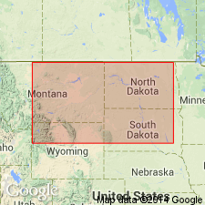
- Areal extent
- AAPG geologic province:
-
- Williston basin
Summary:
Assigned as the lower of two formations of the Elk Point group. Revised to include at base a 1-45 ft thick gray dolomitic siltstone, sandstone or shale that grades into argillaceous dolomite at base that was assigned in earlier reports to the Ashern formation. The overlying 60 to 130 ft thick middle unit is dark gray calcareous shale and siltstone. The upper unit is gray, slightly argillaceous, fossiliferous limestone about 120 ft thick. Lower and middle units merge at center of basin. Overlies Interlake group. Underlies Prairie formation of Elk Point group. Cross section. Correlation chart. Areal extent map; present in the subsurface of the northern part of the Williston basin in ND and adjacent northeast MT. Age is Middle Devonian.
Source: GNU records (USGS DDS-6; Denver GNULEX).
For more information, please contact Nancy Stamm, Geologic Names Committee Secretary.
Asterisk (*) indicates published by U.S. Geological Survey authors.
"No current usage" (†) implies that a name has been abandoned or has fallen into disuse. Former usage and, if known, replacement name given in parentheses ( ).
Slash (/) indicates name conflicts with nomenclatural guidelines (CSN, 1933; ACSN, 1961, 1970; NACSN, 1983, 2005, 2021). May be explained within brackets ([ ]).