The National Geologic Map Database is migrating to a new infrastructure. We apologize for any service disruptions during this process.
|
|---|


- Usage in publication:
-
- Windy Ridge Formation*
- Modifications:
-
- Named
- Dominant lithology:
-
- Tuff
- Breccia
- AAPG geologic province:
-
- Snake River basin
Summary:
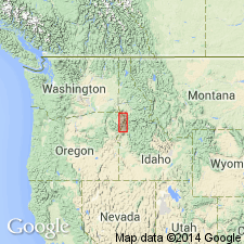
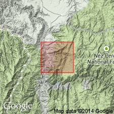
Name given to basal formation of Seven Devils Group (rank raised), a local sequence of metamorphosed silicic volcanic flow and volcaniclastic rocks exposed along south end of Windy Ridge across the Snake River in ID from Oxbow, OR. Extends into Baker Co, OR in the Snake River basin. Not known to crop out elsewhere in northeast OR or western ID. Type locality is along ID Power and Light Company road on east side of Snake River in secs 8 and 17, T19N, R4W, Adams Co, ID in the Snake River basin. Elsewhere exposures are poor and are characterized by scattered, deeply weathered brown-stained outcrops. Is dominantly grayish-green quartz keratophyre tuff, quartz keratophyre tuff-breccia, and quartz keratophyre flows. The flow rocks have a porcelaneous luster and conchoidal to subconchoidal fracture. Chemical and modal analyses. Tuff and tuff breccia are poorly sorted and poorly stratified. Few bedding planes apparent. Grading is rare. Clasts range from sand size to 3 cm in diameter. Major components are quartz keratophyre and keratophyre fragments, albite, and recrystallized pieces of pumice in a quartz and albite matrix. Estimated to be 500 m thick. Base not exposed. Top is difficult to map because of faulting. Is separated from younger, Hunsaker Creek Formation (new) of Seven Devils Group by faulting. Assigned an Early Permian? age. Geologic map. Stratigraphic column.
Source: GNU records (USGS DDS-6; Denver GNULEX).
- Usage in publication:
-
- Windy Ridge Formation*
- Modifications:
-
- Areal extent
- Overview
- AAPG geologic province:
-
- Idaho Mountains province
Summary:
Seven Devils Group divisible into two units: 1) Hunsaker Creek or Windy Ridge Formation; and 2) Doyle Creek Formation in a small area on east side of Salmon River; is not divisible on west side of Salmon River. These mapped areas are in Idaho Co, ID, Idaho Mountains province, where they are part of the Wallowa terrane. The Hunsaker Creek or Windy Ridge map unit is brown-stained, greenschist facies, metamorphosed keratophyre, quartz keratophyre and spilite. The mapped unit also includes metavolcanic flow, tuffaceous and conglomeratic, or breccia rocks. Some primary volcanic textures preserved, but most were obliterated by shearing. Age of cross-cutting gneissic quartz diorite pluton (259 Ma, U/Pb or zircon splits) makes map unit of early Seven Devils age, but bedding and compositional characteristics do not indicate whether unit belongs to Hunsaker Creek (Lower Permian) or Windy Ridge (Lower Permian?).
Source: Modified from GNU records (USGS DDS-6; Denver GNULEX).
For more information, please contact Nancy Stamm, Geologic Names Committee Secretary.
Asterisk (*) indicates published by U.S. Geological Survey authors.
"No current usage" (†) implies that a name has been abandoned or has fallen into disuse. Former usage and, if known, replacement name given in parentheses ( ).
Slash (/) indicates name conflicts with nomenclatural guidelines (CSN, 1933; ACSN, 1961, 1970; NACSN, 1983, 2005, 2021). May be explained within brackets ([ ]).