

- Usage in publication:
-
- Windfall formation*
- Modifications:
-
- Original reference
- Biostratigraphic dating
- Dominant lithology:
-
- Limestone
- AAPG geologic province:
-
- Great Basin province
Summary:
Pg. 19-20, pl. 2. Windfall Formation. Proposed for rocks of Cambrian age at Eureka between Dunderberg shale below and Pogonip group (restricted) above. Formation in Windfall Canyon is close to 650 feet thick, and this figure appears to be approximately correct for whole area of outcrop. At Eureka, divided into two newly defined limestone members (ascending): Catlin, interbedded massive gray limestones, in part cherty, and thin-bedded shaly and sandy limestones; and Bullwhacker, a rather uniform sequence of thin-bedded platy and sandy limestones. Age is Late Cambrian on the basis of fossils [trilobites] identified by A.R. Palmer.
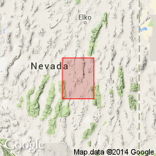
Type locality: Windfall Canyon, just north of the old Windfall Mine [in T. 18 N., R. 35 E.], Eureka mining district, Eureka Co., central NV.
Source: US geologic names lexicon (USGS Bull. 1200, p. 4256); supplemental information from GNU records (USGS DDS-6; Menlo GNULEX).
- Usage in publication:
-
- Windfall formation*
- Modifications:
-
- Biostratigraphic dating
- Revised
- Areal extent
- AAPG geologic province:
-
- Great Basin province
Summary:
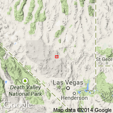
Carbonate rocks on the Nevada Test Site are correlated with the Windfall formation that was originally described in the Eureka district [Eureka Co], NV. Previously referred to as unnamed Upper Cambrian rocks. Thickness is about 1785 ft. Lower part of unit is about 715 ft thick and is considered to be the Catlin member. The upper part is lithologically distinct, and is here named the Smoky member [Catlin is overlain by Bullwhacker member of Windfall in type area near Eureka]. Age is Late Cambrian on the basis of fossils (trilobites, conodonts) identified by A.R. Palmer and R.J. Ross.
Source: GNU records (USGS DDS-6; Menlo GNULEX).
- Usage in publication:
-
- Windfall formation*
- Modifications:
-
- Areal extent
- AAPG geologic province:
-
- Great Basin province
Summary:
Windfall formation (Catlin member) as assigned by Christiansen and Barnes (1966) is restricted from the Groom district [Lincoln County], Nevada, on the basis of lithologic differences between rocks in the Groom district and those at the type locality in the Eureka district [Eureka County], Nevada.
Source: GNU records (USGS DDS-6; Menlo GNULEX).
For more information, please contact Nancy Stamm, Geologic Names Committee Secretary.
Asterisk (*) indicates published by U.S. Geological Survey authors.
"No current usage" (†) implies that a name has been abandoned or has fallen into disuse. Former usage and, if known, replacement name given in parentheses ( ).
Slash (/) indicates name conflicts with nomenclatural guidelines (CSN, 1933; ACSN, 1961, 1970; NACSN, 1983, 2005, 2021). May be explained within brackets ([ ]).