

- Usage in publication:
-
- Willow Point limestone
- Modifications:
-
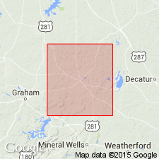
- Areal extent
- Dominant lithology:
-
- Limestone
- AAPG geologic province:
-
- Fort Worth syncline
Summary:
Willow Point limestone, in lower part of Graford formation, lies 40+/- feet above Bridgeport coal. [Age is Pennsylvanian.]
Source: US geologic names lexicon (USGS Bull. 896, p. 2343-2344).
- Usage in publication:
-
- Willow Point limestone
- Modifications:
-
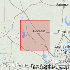
- Areal extent
- Dominant lithology:
-
- Limestone
- AAPG geologic province:
-
- Fort Worth syncline
Summary:
Willow Point limestone, 15+/- feet, lies 105+/- below Rock Hill limestone and 40+/- feet above Bridgeport coal, all included in Graford formation. [Age is Pennsylvanian.]
Source: US geologic names lexicon (USGS Bull. 896, p. 2343-2344).
- Usage in publication:
-
- Willow Point limestone
- Modifications:
-
- Revised
- AAPG geologic province:
-
- Fort Worth syncline
Sellards, E.H., 1931, [Discussion in News Letter, September, 1931]: University of Texas-Austin, Bureau of Economic Geology
Summary:
In Wise County [central northern Texas] the Palo Pinto limestone has been found to be divided into 2 thin limestones separated by shale. The limestones are named Boone Creek and Willow Point. [Age is Pennsylvanian.]
Source: US geologic names lexicon (USGS Bull. 896, Boone Creek entry p. 236-237).
- Usage in publication:
-
- Willow Point limestone
- Modifications:
-
- Principal reference
- Dominant lithology:
-
- Limestone
- AAPG geologic province:
-
- Fort Worth syncline
Summary:
Pg. 27. Willow Point limestone. Included in Palo Pinto formation. Is about 4 feet thick. Consists almost entirely of broken fragments of crinoid stems and many other reworked fossils. When fresh it is light- to dark-gray, hard, and crystalline, but weathers easily to yellowish collor and breaks down into a "rotten" limestone. Named from Willow Point, southwestern part of Wise County, central northern Texas. Also well exposed at Bridgeport and other places in western part of Wise County. Was originally called Bridgeport limestone by Bose, but since he had already spoken of the coal in connection with Bridgeport it is thought best to retain that name for the coal. It lies 32 to 55 feet above Bridgeport coal. [Age is Pennsylvanian.]
Source: US geologic names lexicon (USGS Bull. 896, p. 2343-2344).

- Usage in publication:
-
- Willow Point limestone
- Modifications:
-
- Overview
- AAPG geologic province:
-
- Fort Worth syncline
Summary:
Pg. 105. Willow Point limestone, in Palo Pinto formation, replaces Bridgeport limestone (preoccupied). [Age is Pennsylvanian.]
Source: US geologic names lexicon (USGS Bull. 896, p. 2343-2344).

- Usage in publication:
-
- Willow Point Limestone Member/
- Willow Point Formation/
- Modifications:
-
- Mapped 1:250k
- Dominant lithology:
-
- Limestone
- AAPG geologic province:
-
- Fort Worth syncline
Summary:
Pamphlet [p. 15]. /Willow Point Formation of Canyon Group. Shale and claystone in units 8 to 40 feet thick, medium- and dark-gray, grayish-purple, weather to tan and yellowish-brown, locally silty and sandy, ferruginous concretions throughout, locally very fossiliferous with brachiopods, corals, gastropods, pelecypods, cephalopods, and crinoids. Includes, descending:
(1) /Willow Point Limestone Member at top, light-gray, weathers to yellowish-brown, fine- to coarse-grained, locally fossiliferous, thin- to thick-bedded, a few thin shale interbeds, forms erosional bench and dip slope, locally covered by Cretaceous deposits, thickness 3 to 6 feet;
(2) Bridgeport coal (unmapped) in single bed 18 to 22 inches thick and 32 to 55 feet below Willow Point Limestone Member;
(3) at least five unmapped limestone beds (Balsora, Sanders Bridge, Boone Creek, Martin Lake, and Hudson Bridge Limestones) in lower part, locally exposed in streamcuts along contact with Cretaceous deposits, correlation of unmapped limestone beds between discontinuous outcrops uncertain, medium-gray, light-brown, reddish-brown, fine- to coarse-grained, well-indurated, bioclastic, thin- to thick-bedded, irregularly bedded, 1 to 7 feet thick; and
(4) at base, ss1, sandstone, brown, fine- to medium-grained, locally conglomeratic, mostly massive, locally cross-bedded, friable, ferruginous cement, poorly exposed in stream valleys, thickness 10 to 20 feet.
Total thickness of formation approximately 100 to 150 feet. Is basal formation of Canyon Group; = lower and middle Palo Pinto Formation exposed southwest of map area. Lies below Jasper Creek Formation of Canyon Group.
[Mapped in Lake Bridgeport area, Jack and Wise Cos., central northern TX; western edge of map sheet. Rocks previously (1967 ed. of map) included in Palo Pinto Formation and Lake Bridgeport Shale Member of Graford Formation. See also adjacent Wichita Falls-Lawton sheet, Texas Geol. Atlas, 1987.]
[An identical geographic name may not be applied to a stratigraphic unit [Willow Point Formation] and its parts [Willow Point Limestone Member] (CSN, 1933; ACSN, 1961, 1970; NACSN, 1983, 2005, 2021).]
Source: Publication.
For more information, please contact Nancy Stamm, Geologic Names Committee Secretary.
Asterisk (*) indicates published by U.S. Geological Survey authors.
"No current usage" (†) implies that a name has been abandoned or has fallen into disuse. Former usage and, if known, replacement name given in parentheses ( ).
Slash (/) indicates name conflicts with nomenclatural guidelines (CSN, 1933; ACSN, 1961, 1970; NACSN, 1983, 2005, 2021). May be explained within brackets ([ ]).