

- Usage in publication:
-
- Wilbert Formation*
- Modifications:
-
- Named
- Dominant lithology:
-
- Quartzite
- AAPG geologic province:
-
- Snake River basin
Summary:
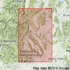
Named for exposures near Wilbert mine in southern Lemhi Range, Butte Co, ID in Snake River basin. These exposures are the type section. Is mostly red-brown, gray, coarse-fine- to very fine-grained, some beds poorly sorted, subangular to subround quartz. Is poorly sorted, partly laminated and cross laminated, hematitic, partly glauconitic to partly calcareous. Ranges from 0-1,000 ft (310 m) thick. Is 953 ft at type. Measured sections. Overlies Swauger Formation (Precambrian Y). Underlies Lower Ordovician Summerhouse Formation with angular unconformity at type. Overlies Gunsight Formation (Precambrian Y) from North Creek to Foss Mountain. Known in southern one-third of Lemhi Range and Beaverhead Mountains. Is equivalent to Windermere and Brigham Groups and Mutual Formation. Assigned to Precambrian Z.
Source: GNU records (USGS DDS-6; Denver GNULEX).
- Usage in publication:
-
- Wilbert Formation*
- Modifications:
-
- Areal extent
- Age modified
- AAPG geologic province:
-
- Idaho Mountains province
- Snake River basin
Summary:
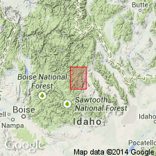
Exposed in southern part of Lemhi Range, Beaverhead Mountains, and northern and west-central flank of Lost River Range, Lemhi and Custer Cos in the Idaho Mountains province, and in Butte and Clark Cos in the Snake River basin. Is 120 m thick in south part of Lemhi Range. Thins north. Pinches out about 30-35 km south of Gilmore quad, Custer and Lemhi Cos. Northward thinning due to onlap onto Late Proterozoic erosion surface and to early Paleozoic erosion. Overlies Swauger and Gunsight Formations with angular unconformity. Underlies Kinnikinic Quartzite. Fossils of middle Early Cambrian age found in uppermost 35 m of formation in southernmost part of Lemhi Range. No fossils have been found in lower part. Age of lower part considered Late Proterozoic and perhaps partly Cambrian. Age changed from Late Proterozoic to Late Proterozoic(?) and Early Cambrian.
Source: GNU records (USGS DDS-6; Denver GNULEX).
- Usage in publication:
-
- Wilbert Formation*
- Modifications:
-
- Age modified
- Areal extent
- AAPG geologic province:
-
- Idaho Mountains province
- Montana folded belt
Summary:
Name used in the southern Beaverhead Mountains of ID (Idaho Mountains province) and adjacent MT (Montana folded belt province) where it is considered to be of Late Proterozoic age and is overlain by Early Ordovician or younger Paleozoic rocks. No Cambrian fossils have been found in it in the Beaverheads. However, it is considered to be of Late Proterozoic(?) and Early Cambrian age in the Lemhi Range in Lemhi Co, ID where it has Early Cambrian fossils in the upper 115 ft. Middle and Upper Cambrian strata missing and some of Lower Cambrian may be missing in the southern and central Beaverheads. Resembles Late Proterozoic Mutual Formation and the Late Proterozoic and Lower Cambrian Camelback Mountain Quartzite of Brigham Group south of Snake River plain. Probably deposited in a northeast-trending extensional basin about 50 mi long. The basin was probably in the northern arm of a large rift system. Basin bounded on north and west by Middle Proterozoic rocks and on east by Archean(?) metamorphic rocks.
Source: GNU records (USGS DDS-6; Denver GNULEX).
For more information, please contact Nancy Stamm, Geologic Names Committee Secretary.
Asterisk (*) indicates published by U.S. Geological Survey authors.
"No current usage" (†) implies that a name has been abandoned or has fallen into disuse. Former usage and, if known, replacement name given in parentheses ( ).
Slash (/) indicates name conflicts with nomenclatural guidelines (CSN, 1933; ACSN, 1961, 1970; NACSN, 1983, 2005, 2021). May be explained within brackets ([ ]).