The National Geologic Map Database is migrating to a new infrastructure. We apologize for any service disruptions during this process.
|
|---|


- Usage in publication:
-
- Wichita granite group
- Modifications:
-
- First used
- Dominant lithology:
-
- Granite
- AAPG geologic province:
-
- South Oklahoma folded belt
- Anadarko basin
- Palo Duro basin
Summary:
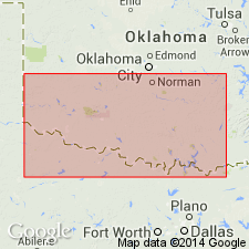
First published use. Report area is in southern Oklahoma, where the /Wichita Granite Group is present in (east to west, mostly subsurface): western Jefferson, Cotton, Comanche, Kiowa, and Greer Counites [South Oklahoma folded belt province]; Beckham and Washita Counties [Anadarko basin]; and Jackson and Harmon Counties [Palo Duro basin]. Consists chiefly of perthite leucogranites of various textures representing multiple intrusions, in part having the form of extensive sills, 600 to 1,500 feet thick, that intrude the lower part of the /Carlton Rhyolite Group (revised) [Carlton is the extrusive equivalent of Wichita], and in part occurring as irregular plutons and sills cutting all other rocks of the "Wichita Province." Older than Reagan Sandstone, Honey Creek Limestone, and lower part of Arbuckle Group (all of Late Cambrian age). Younger than the extrusive /Navajoe Mountain Basalt-Spilite Group and its intrusive equivalent, /Raggedy Mountain Gabbro Group (both new, and of Early Cambrian(?) age). Age is Middle Cambrian(?), 525 +/-25 Ma, based on four isotopic age determinations. Report includes geologic map, generalized sections.
Derivation of name not stated, but probably named from Wichita Mountains, in southern OK.
[Wichita Granite Group preempted by Wichita [Group] of Cummins (1890) in TX; conflicts with nomenclature guidelines stating a group name combines a geographic name with the term "group," and no lithic designation is included (ACSN, 1961, 1970; NACSN, 1983, 2005, 2021).]
Source: Modified from GNU records (USGS DDS-6; Denver GNULEX).
- Usage in publication:
-
- Wichita Granite Group
- Modifications:
-
- Named
- Dominant lithology:
-
- Granite
- AAPG geologic province:
-
- South Oklahoma folded belt
Summary:
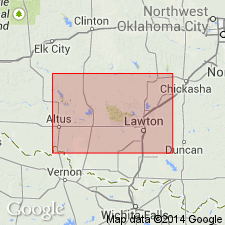
Pg. 60-79, pls. Wichita Granite Group. Dominant outcropping rock in Wichita Mountains is pink, medium-grained granite. The granite rocks consists of several types. They differ in texture, mineral composition, and to some extend in age. Intrusive relations indicate at least four separate granitic injections and possibly six. Term /Wichita Granite Group proposed for this assemblage of closely allied rocks. Wichita Granite Group occurs at surface and in subsurface over an area of not less than 15,000 sq. mi. in southern Oklahoma. Also extends in subsurface, about 25 miles westward, into Collingsworth and Wheeler Counties, Texas (Palo Duro basin). Granites are characterized as perthite-quartz leucogranites consisting of one-third quartz, two-thirds potassium feldspar, and 2 to 5 percent ferromagnesian minerals; grain sizes range from 0.3 to 20 mm. Thickness is at least 1,500 feet. Included in group are granites previously mapped on outcrop as Lugert, Headquarters, Reformatory, Quanah, and Cold Springs, as well as their subsurface equivalents. Intrudes lower part of /Carlton Rhyolite Group (new); overlies /Navajoe Mountain Basalt-Spilite Group (new). Age is Middle Cambrian(?), 525 +/-m.y., based on isotopic age determinations. Report includes petrographic data, chemical analyses.
Type locality not designated. Named from Wichita Mountains in Comanche and Kiowa Cos., southern OK, where unit is well exposed (S. Oklahoma folded belt province).
[Wichita Granite Group preempted by Wichita [Group] of Cummins (1890) in TX; conflicts with nomenclature guidelines stating a group name combines a geographic name with the term "group," and no lithic designation is included (ACSN, 1961, 1970; NACSN, 1983, 2005, 2021).]
Source: US geologic names lexicon (USGS Bull. 1350, p. 828); supplemental information from GNU records (USGS DDS-6; Denver GNULEX).
- Usage in publication:
-
- Wichita Granite Group
- Modifications:
-
- Revised
- AAPG geologic province:
-
- Palo Duro basin
- South Oklahoma folded belt
Summary:
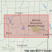
/Wichita Granite Group revised to include newly named Mount Scott Granite, in Wichita Mountains, Oklahoma [spelled Mt. Scott in this report; changed to Mount Scott in subsequent reports]. Wichita Granite Group is comprised of (oldest to youngest): Mount Scott Granite, Lugert Granite, and Quanah Granite. The Mount Scott Granite forms half of the outcrop area in eastern and central parts of Wichita Mountains; was emplaced as an intrusive sheet that must have had an areal extent of hundreds of square miles; outcrops are found in an area of 25 to 35 miles. On accompanying geologic map, Mount Scott is shown to be present in Comanche, Kiowa, Jackson, and northernmost Tillman Counties (S. Oklahoma folded belt province and Palo Duro basin). Formerly mapped as Lugert Granite by Taylor (1915) and by Hoffman (1930); writer believes sufficient evidence has accumulated to designate it as a separate granite. Differs from Lugert in that it is granophyric and contains elliptical zoned feldspars. Mount Scott is the oldest granite in the eastern part of the Wichita Mountains. Intruded by Lugert Granite in the Snyder area, Kiowa County, and by the Quanah Granite in several places in sec. 15, T. 3 N., R. 15 W., Comanche County. Age of Wichita Granite Group is Middle Cambrian(?), approximately 525 m.y., based on isotopic dates provided by Tilton, Wetherill, and Davis (1962). Report includes geologic map, chemical analyses.
[Wichita Granite Group preempted by Wichita [Group] of Cummins (1890) in TX; conflicts with nomenclature guidelines stating a group name combines a geographic name with the term "group," and no lithic designation is included (ACSN, 1961, 1970; NACSN, 1983, 2005, 2021).]
Source: GNU records (USGS DDS-6; Denver GNULEX); US geologic names lexicon (USGS Bull. 1350, p. 512, 828).
- Usage in publication:
-
- Wichita Granite Group
- Modifications:
-
- Revised
- AAPG geologic province:
-
- South Oklahoma folded belt
Summary:
Study area is within Wichita Mountains, southwestern Oklahoma (S. Oklahoma folded belt province). /Wichita Granite Group provisionally revised, from consisting of 5 units (Mount Scott, Headquarters, Reformatory, Lugert, and Quanah) to 10 units (with the addition of Cache, Cooperton, Long Mountain, Medicine Park, and Saddle Mountain). Wichita igneous province divided into eastern and western provinces. Eastern province contains largest area of outcrop, but most of existing nomenclature originated in western part. In the eastern province, the Wichita Granite Group (revised) consists of: Mount Scott Granite, Saddle Mountain Formation, Medicine Park Formation, Cache Formation, and Quanah Granite. In the western province, the Wichita consists of: Mount Scott Granite, Headquarters Granite, Reformatory Granite, Long Mountain Formation, Cooperton Formation, and Lugert Granite. Wichita Granite Group is intrusive equivalent of /Carlton Rhyolite Group. Is older than Cold Springs Breccia and younger than /Raggedy Mountain Gabbro Group. Age of Wichita is Middle Cambrian (525 +/-25 m.y.). Report includes geochemistry, stratigraphic table, map showing distribution of units.
[Wichita Granite Group preempted by Wichita [Group] of Cummins (1890) in TX; conflicts with nomenclature guidelines stating a group name combines a geographic name with the term "group," and no lithic designation is included (ACSN, 1961, 1970; NACSN, 1983, 2005, 2021).]
Source: Modified from GNU records (USGS DDS-6; Denver GNULEX).
For more information, please contact Nancy Stamm, Geologic Names Committee Secretary.
Asterisk (*) indicates published by U.S. Geological Survey authors.
"No current usage" (†) implies that a name has been abandoned or has fallen into disuse. Former usage and, if known, replacement name given in parentheses ( ).
Slash (/) indicates name conflicts with nomenclatural guidelines (CSN, 1933; ACSN, 1961, 1970; NACSN, 1983, 2005, 2021). May be explained within brackets ([ ]).