

- Usage in publication:
-
- White Tail Ridge Member
- Modifications:
-
- Named
- Dominant lithology:
-
- Sandstone
- Siltstone
- Coal
- AAPG geologic province:
-
- Oregon-Washington Coast Ranges province
- Klamath Mountains province
Summary:
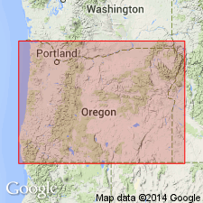
Named for White Tail Ridge as lower of two members of Flournoy Formation (new). Makes up White Tail Ridge and Sugar Pine Ridge in Camas Valley quad, Douglas Co, OR. Composed of sandstone, siltstone, and conglomerate. All sandstone formerly mapped as Tyee along Coos and Millacoma Rivers is now assigned to White Tail Ridge member. Coal reported by Theasher (1942) from Melrose and Camas Mountain areas. Is 1500 ft thick along Lookingglass Creek. Is 4000 to 5000 ft along Coos River. Unconformably overlies Lookingglass Formation (new). Underlies Camas Valley Member (new) (Flournoy Formation) or unconformably underlies Tyee Formation. Age is middle Eocene based on stratigraphic position of Flournoy Formation.
Source: GNU records (USGS DDS-6; Menlo GNULEX).

- Usage in publication:
-
- White Tail Ridge Member
- Modifications:
-
- Revised
- AAPG geologic province:
-
- Oregon-Washington Coast Ranges province
- Klamath Mountains province
Summary:
White Tail Ridge Member of Flournoy Formation of Baldwin (1974) included in Umpqua Group. [Author discusses reasons for raising rank of Umpqua.] "No unconformity was observed by the writer between Lookingglass and Flournoy Formations" p.520.
Source: GNU records (USGS DDS-6; Menlo GNULEX).
- Usage in publication:
-
- White Tail Ridge Member
- Modifications:
-
- Revised
- AAPG geologic province:
-
- Oregon-Washington Coast Ranges province
- Klamath Mountains province
Summary:
Olalla Creek Member of Lookingglass Formation and White Tail Ridge Member of Flournoy Formation of Baldwin (1974) are included as second from uppermost member, White Tail Ridge Member, of Umpqua Formation. Baldwin's (1974) Olalla Creek Member is interpreted as more landward facies of White Tail Ridge Member. Overlies Tenmile Member; underlies Camas Valley Member (both of Umpqua Formation). Age is middle Eocene. [members of Umpqua Formation are not adopted in this paper]
Source: GNU records (USGS DDS-6; Menlo GNULEX).
For more information, please contact Nancy Stamm, Geologic Names Committee Secretary.
Asterisk (*) indicates published by U.S. Geological Survey authors.
"No current usage" (†) implies that a name has been abandoned or has fallen into disuse. Former usage and, if known, replacement name given in parentheses ( ).
Slash (/) indicates name conflicts with nomenclatural guidelines (CSN, 1933; ACSN, 1961, 1970; NACSN, 1983, 2005, 2021). May be explained within brackets ([ ]).