

- Usage in publication:
-
- White Hills Member*
- Modifications:
-
- Original reference
- Dominant lithology:
-
- Sandstone
- Conglomerate
- AAPG geologic province:
-
- Alaska Northern region
Summary:
Pg. 5 (fig. 4), 6-8 (table 1), 39+. White Hills Member of Sagavanirktok Formation. Lower part exposed in the White Hills and along Toolik River, northern Alaska, is a conspicuous, poorly consolidated, white-weathering conglomerate and sandstone, about 160 feet thick. Upper part exposed a short distance south of Franklin Bluffs, northern Alaska, is a brown-weathering, silty mudstone with thin discontinuous lignite interbeds, 80 feet thick. Overlies Sagwon Member; underlies Franklin Bluffs Member (both of Sagavanirktok Formation). Age is considered early Tertiary (late Paleocene? to early Eocene), based on stratigraphic relations.
Type section (lower part): exposures in stream cut in northwestern White Hills, in E/2 sec. 5, T. 2 N., R. 10 E. [Sagavanirktok C-5 quadrangle, scale 1:63,360], northern AK.
Reference section [composite]: (1) lower part, on southeast side of the White Hills in a meander of the Toolik River, in NW/4 sec. 28 and NE/4 sec. 29, T. 2 N., R. 12 E. [along bdry. btw. Sagavanirktok C-4 and B-4 quadrangles, scale 1:63,360], northern AK; (2) upper part, a short distance south of Franklin Bluffs, in W/2 sec. 27, T. 5 N., R. 14 E. [along southern bdry. Sagavanirktok D-3 quadrangle, scale 1:63,360], northern AK.
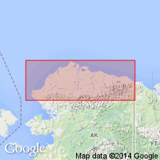
Named from White Hills, a prominent rolling upland area on Arctic Coastal Plain, 12–35 mi west of the Sagavanirktok River and 45 mi southwest of Prudhoe Bay, northern Alaska.
Source: Publication.
For more information, please contact Nancy Stamm, Geologic Names Committee Secretary.
Asterisk (*) indicates published by U.S. Geological Survey authors.
"No current usage" (†) implies that a name has been abandoned or has fallen into disuse. Former usage and, if known, replacement name given in parentheses ( ).
Slash (/) indicates name conflicts with nomenclatural guidelines (CSN, 1933; ACSN, 1961, 1970; NACSN, 1983, 2005, 2021). May be explained within brackets ([ ]).