The National Geologic Map Database is migrating to a new infrastructure. We apologize for any service disruptions during this process.
|
|---|


- Usage in publication:
-
- Whim Hill breccia
- Modifications:
-
- Original reference
- Dominant lithology:
-
- Breccia
- AAPG geologic province:
-
- Basin-and-Range province
Summary:
Pg. 289-291, fig. 3, pl. 1. Whim Hill breccia. Compact mass of angular blocks firmly cemented by matrix rich in magnetite. Fragments represent a number of rock types known to occur in the stratigraphic section. Broken pieces of biotite granodiorite porphyry predominate. Angular and rounded fragments of indurated shales and quartzites, which probably came from Beartooth and Colorado formations, included.
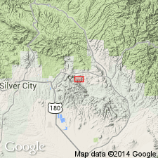
Two areas of exposure in northern part of Santa Rita stock; larger, comprises area of over 40,000 sq ft and forms elongate mass in central part of North Pit; second body found on northern edge of Central Island between North and South Pits. In Santa Rita copper mine, in southeastern corner of Santa Rita quadrangle, about 12 mi east of Silver City, Grant Co., southwestern NM.
Source: GNU records (USGS DDS-6; Denver GNULEX).
For more information, please contact Nancy Stamm, Geologic Names Committee Secretary.
Asterisk (*) indicates published by U.S. Geological Survey authors.
"No current usage" (†) implies that a name has been abandoned or has fallen into disuse. Former usage and, if known, replacement name given in parentheses ( ).
Slash (/) indicates name conflicts with nomenclatural guidelines (CSN, 1933; ACSN, 1961, 1970; NACSN, 1983, 2005, 2021). May be explained within brackets ([ ]).