

- Usage in publication:
-
- Westernport sandstone
- Modifications:
-
- Named
- Dominant lithology:
-
- Sandstone
- AAPG geologic province:
-
- Appalachian basin
Summary:
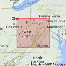
Name Westernport sandstone applied to the massive coarse yellowish-gray rock that is usually found 290 to 300 ft above Pittsburg coal, and that caps summit of Westernport Hill, near Westernport, MD.
Source: GNU records (USGS DDS-6; Reston GNULEX).
- Usage in publication:
-
- Westernport sandstone
- Modifications:
-
- Overview
- AAPG geologic province:
-
- Appalachian basin
Summary:
Westernport is a massive sandstone, gray, coarse-grained and cross-bedded at many places. Contains interbedded lenses of shale. Rests on Luke (Middle Kittanning) coal and underlies fire clay beneath Piney Mountain coal. Forms bold cliffs along the Potomac west of Westernport, Allegany Co., MD, where it is 40 ft thick.
Source: GNU records (USGS DDS-6; Reston GNULEX).
- Usage in publication:
-
- Westernport sandstone
- Modifications:
-
- Areal extent
- AAPG geologic province:
-
- Appalachian basin
Summary:
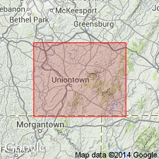
Unit described in Fayette Co., PA, where it lies between Upper and Lower Kittanning coals. Commonly divided into two parts by Johnstown limestone and Middle Kittanning coal. In vicinity of Normalville and Whites Bridge, the parts coalesce and cut out intervening limestone and coal. Thickness 30 to 60 ft. Included in Allegheny group.
Source: GNU records (USGS DDS-6; Reston GNULEX).
For more information, please contact Nancy Stamm, Geologic Names Committee Secretary.
Asterisk (*) indicates published by U.S. Geological Survey authors.
"No current usage" (†) implies that a name has been abandoned or has fallen into disuse. Former usage and, if known, replacement name given in parentheses ( ).
Slash (/) indicates name conflicts with nomenclatural guidelines (CSN, 1933; ACSN, 1961, 1970; NACSN, 1983, 2005, 2021). May be explained within brackets ([ ]).