The National Geologic Map Database is migrating to a new infrastructure. We apologize for any service disruptions during this process.
|
|---|


- Usage in publication:
-
- Wepo formation*
- Modifications:
-
- Named
- Dominant lithology:
-
- Siltstone
- Mudstone
- Sandstone
- AAPG geologic province:
-
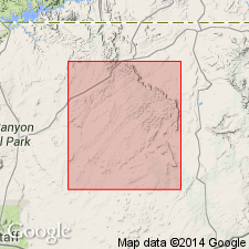
- Black Mesa basin
Summary:
Named as middle formation of Mesaverde group at Black Mesa, AZ. Type section measured 7 mi northeast of town of Pinon on west side of Wepo Wash, central Black Mesa in the Black Mesa basin. Consists of intercalated siltstone, mudstone, sandstone, and coal of continental origin. Measured sections. Thins to northeast across Black Mesa. Is 743 ft thick east of Cow Springs and 318 ft thick at Rough Rock on northeast. The siltstone and mudstone are olive gray to olive brown, locally carbonaceous, flat-bedded, laminated to very thin, with very low-angle trough cross beds. Sandy zones and sandstone lenses are present. The sandstone is yellow gray, cross bedded, weakly cemented, poorly sorted, very coarse to fine grained, subround to subangular clear frosted quartz. Has some argillaceous units. Altered feldspar and mica present at most localities. Coal is mined from the Wepo. Is unfossiliferous. Is thought to correlate with Crevasse Canyon formation, parts of Gallup and Straight Cliffs sandstones. Wepo overlies Toreva formation and underlies Yale Point sandstone, both newly named formations of Mesaverde group.
Source: GNU records (USGS DDS-6; Denver GNULEX).
- Usage in publication:
-
- Wepo Formation*
- Modifications:
-
- Revised
- AAPG geologic province:
-
- Black Mesa basin
Summary:
An informal unit on the northeast side of Black Mesa that was assigned to the Toreva Formation by Repenning and Page (1956) is recognized as belonging to the Wepo Formation. The unit was part of the "main ledge" of the Toreva and is reassigned as the lower carbonaceous member of the Wepo. The lower member is separated from the upper carbonaceous member by Wind Rock Tongue (new) of Mancos Shale and overlying Rough Rock Sandstone of Mesaverde Group.
Source: GNU records (USGS DDS-6; Denver GNULEX).
For more information, please contact Nancy Stamm, Geologic Names Committee Secretary.
Asterisk (*) indicates published by U.S. Geological Survey authors.
"No current usage" (†) implies that a name has been abandoned or has fallen into disuse. Former usage and, if known, replacement name given in parentheses ( ).
Slash (/) indicates name conflicts with nomenclatural guidelines (CSN, 1933; ACSN, 1961, 1970; NACSN, 1983, 2005, 2021). May be explained within brackets ([ ]).