

- Usage in publication:
-
- Wellesley formation*
- Modifications:
-
- Named
- Biostratigraphic dating
- Dominant lithology:
-
- Conglomerate
- Slate
- AAPG geologic province:
-
- Alaska East-Central region
Summary:
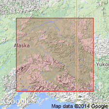
Occurs on Wellesley Mountain, east-central AK, in area north of mountain and in area in Yukon Territory south of Snag River as shown on geologic sketch map of portion of White and Tanana River basins. Can be divided into lower part of coarse massive conglomerate interlarded with few beds of blue clay slate and upper part of blue clay slate, locally altered to phyllite. Minimum thickness is between 1000 and 2000 ft. Unconformably overlies greenstone schists. Intruded by granite dike and small porphyritic dike. Few nuculoid fossils which Charles Schuchert identified as of Devonian or Carboniferous age were found in Snag River Valley.
Source: GNU records (USGS DDS-6; Menlo GNULEX).
- Usage in publication:
-
- Wellesley formation*
- Modifications:
-
- Age modified
- AAPG geologic province:
-
- Alaska East-Central region
Summary:
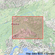
Referring to Brooks (1900), writer says type locality [at Wellesley Mountain between Tanana and White Rivers, east-central AK] has thickness between 1000 and 2000 ft. Described as heavy quartz and chert conglomerate and black slate overlying greenstone schists which are regarded as part of Birch Creek schist. Fossils indicate upper Paleozoic age. Correlation chart shows Carboniferous age.
Source: GNU records (USGS DDS-6; Menlo GNULEX).
- Usage in publication:
-
- "Wellesley formation"
- Modifications:
-
- Not used
- Age modified
- AAPG geologic province:
-
- Alaska East-Central region
Summary:
"Although the name 'Wellesley formation' was used as a local designation by the writer [Mertie, 1931] in an earlier report dealing with the geology of this southeastern part of the Yukon-Tanana region, it seems best in this report to include the formation in the undifferentiated non-calcareous Mississippian unit." p.119
Source: GNU records (USGS DDS-6; Menlo GNULEX).
For more information, please contact Nancy Stamm, Geologic Names Committee Secretary.
Asterisk (*) indicates published by U.S. Geological Survey authors.
"No current usage" (†) implies that a name has been abandoned or has fallen into disuse. Former usage and, if known, replacement name given in parentheses ( ).
Slash (/) indicates name conflicts with nomenclatural guidelines (CSN, 1933; ACSN, 1961, 1970; NACSN, 1983, 2005, 2021). May be explained within brackets ([ ]).