The National Geologic Map Database is migrating to a new infrastructure. We apologize for any service disruptions during this process.
|
|---|


- Usage in publication:
-
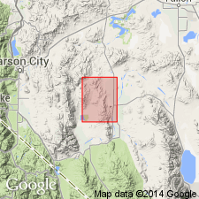
- Weed Heights Member
- Modifications:
-
- Named
- Dominant lithology:
-
- Dacite
- Latite
- Tuff
- AAPG geologic province:
-
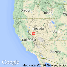
- Great Basin province
Summary:
Named as upper member of two named units in Mickey Pass Tuff (new). Type area designated as exposures 0.8 km southwest of Weed Heights, Singatse Range, Lyon Co, NV. Composed of silicic dacite, quartz latite, and rhyolite ash-flow tuff with basal vitrophyre. Color ranges from buff, lavender to reddish-brown. Thickness is generally 120 m with range of 30 to 180 m. Overlies Guild Mine Member (new) or intervening unnamed map units 4 or 5 of Mickey Pass Tuff. Underlies Singatse Tuff or intervening map unit 7 at top of Mickey Pass Tuff. Is Oligocene age based on K-Ar ages on biotite of 27.8 +/-1.0 Ma and on sanidine of 26.1 +/-0.9 Ma.
Source: GNU records (USGS DDS-6; Menlo GNULEX).
- Usage in publication:
-
- Weed Heights Member*
- Modifications:
-
- Revised
- AAPG geologic province:
-
- Great Basin province
Summary:
Weed Heights Member of Mickey Pass Tuff included in Benton Spring Group. In southern Gabbs Valley Range lowest 20 to 30 m of Singatse Tuff is included in Weed Heights Member on basis of mineralogic evidence and cooling break between.
Source: GNU records (USGS DDS-6; Menlo GNULEX).
For more information, please contact Nancy Stamm, Geologic Names Committee Secretary.
Asterisk (*) indicates published by U.S. Geological Survey authors.
"No current usage" (†) implies that a name has been abandoned or has fallen into disuse. Former usage and, if known, replacement name given in parentheses ( ).
Slash (/) indicates name conflicts with nomenclatural guidelines (CSN, 1933; ACSN, 1961, 1970; NACSN, 1983, 2005, 2021). May be explained within brackets ([ ]).