The National Geologic Map Database is migrating to a new infrastructure. We apologize for any service disruptions during this process.
|
|---|


- Usage in publication:
-
- Webb Formation*
- Modifications:
-
- Original reference
- Biostratigraphic dating
- Dominant lithology:
-
- Mudstone
- Claystone
- AAPG geologic province:
-
- Great Basin province
Summary:
Pg. I8-I12, I16-I17. Webb Formation. Siliceous mudstone and claystone. Is a wedge-shaped unit. Unconformably overlies the Devils Gate Limestone, Woodruff Formation, and Vinini Formation; conformably underlies the Chainman Shale. Age is Early Mississippian based on fossils [conodonts].
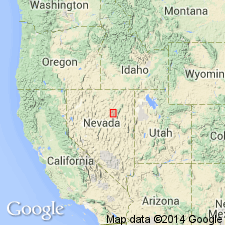
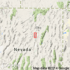
Type section: near northern edge of sec. 19, T. 31 N., R. 53 E., and in SE/4 sec. 13, T. 31 N., R. 52 E., 17 km southeast of Carlin, Elko Co., northeastern NV. Named from exposures near Webb Creek.
Source: US geologic names lexicon (USGS Bull. 1520, p. 330).
- Usage in publication:
-
- Webb Formation*
- Modifications:
-
- Revised
- AAPG geologic province:
-
- Great Basin province
Summary:
Webb Formation is restricted to include the unnamed argillite unit of Lee Canyon (Smith and Ketner, 1975; 1978) and to exclude predominantly carbonate rocks south and east of the Bald Mountain and Lee Canyon faults in the upper valley of Trout Creek originally mapped as part of the Webb. Age is Early Mississippian.
Source: GNU records (USGS DDS-6; Menlo GNULEX).
For more information, please contact Nancy Stamm, Geologic Names Committee Secretary.
Asterisk (*) indicates published by U.S. Geological Survey authors.
"No current usage" (†) implies that a name has been abandoned or has fallen into disuse. Former usage and, if known, replacement name given in parentheses ( ).
Slash (/) indicates name conflicts with nomenclatural guidelines (CSN, 1933; ACSN, 1961, 1970; NACSN, 1983, 2005, 2021). May be explained within brackets ([ ]).