

- Usage in publication:
-
- Waterfall Greenstone*
- Modifications:
-
- Named
- Dominant lithology:
-
- Greenstone
- Graywacke
- Chert
- Marble
- AAPG geologic province:
-
- Alaska Southeastern region
Summary:
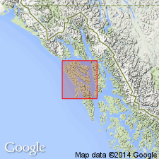
Typically exposed in ridge lying immediately east and north of Waterfall Lake in western Chichagof Island, southeastern AK. Appears to wedge out to southeast near Cobol on Slocum Arm. Rocks formerly part of "schist" unit of Reed and Coats (1941) and Rossman (1959). Consists predominantly of greenstone but contains lesser amounts of graywacke, greenschist, radiolarian chert, and marble. Overlies Pinnacle Peak Phyllite (new). Is probably transitional both upwards and laterally with Kelp Bay Group. Assigned Triassic(?) age.
Source: GNU records (USGS DDS-6; Menlo GNULEX).
- Usage in publication:
-
- Waterfall Greenstone*
- Modifications:
-
- Revised
- AAPG geologic province:
-
- Alaska Southeastern region
Summary:
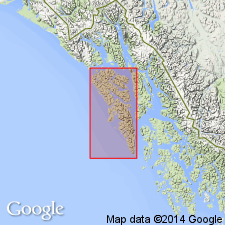
Typical exposures on ridge east and north of Waterfall Lake (described by Loney and others, 1963) are considered type locality. Waterfall Greenstone is assigned to Kelp Bay Group. Age is Triassic(?) based on relationship to Whitestripe Marble. Tentatively correlated with unnamed greenstone unit of undivided Kelp Bay Group on Baranof Island.
Source: GNU records (USGS DDS-6; Menlo GNULEX).
- Usage in publication:
-
- Waterfall Greenstone*
- Modifications:
-
- Age modified
- Biostratigraphic dating
- AAPG geologic province:
-
- Alaska Southeastern region
Summary:
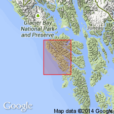
Waterfall Greenstone of Kelp Bay Group is assigned to informal Freeburn assemblage of Chugach terrane. Radiolarian collections from lenses of chert in unit have yielded diagnostic Radiolaria of Early Cretaceous age (Charles Blome, oral commun., 1980). Therefore, unit is assigned Early Cretaceous age.
Source: GNU records (USGS DDS-6; Menlo GNULEX).
For more information, please contact Nancy Stamm, Geologic Names Committee Secretary.
Asterisk (*) indicates published by U.S. Geological Survey authors.
"No current usage" (†) implies that a name has been abandoned or has fallen into disuse. Former usage and, if known, replacement name given in parentheses ( ).
Slash (/) indicates name conflicts with nomenclatural guidelines (CSN, 1933; ACSN, 1961, 1970; NACSN, 1983, 2005, 2021). May be explained within brackets ([ ]).