The National Geologic Map Database is migrating to a new infrastructure. We apologize for any service disruptions during this process.
|
|---|


- Usage in publication:
-
- Wapanucka limestone*
- Modifications:
-
- First used
- Dominant lithology:
-
- Limestone
- Shale
- Sandstone
- Chert
- AAPG geologic province:
-
- Arkoma basin
- South Oklahoma folded belt
- Ouachita folded belt
Summary:
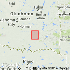
First published use of name; intent to name not stated, and no type locality designated. Origin of name not stated, but probably named for Wapanucka, in Johnston Co, OK. Crops out as narrow band along eastern border of the older Caney shale (new) in southeast and southwest corners of Coalgate quad, Coal Co, OK, Arkoma basin. Is extensive but thin lentil reaches beyond quad borders. Produces ridges, except where beds are overturned, allowing shale on both sides to erode, leaving limestone unprotected. Abrupt ending of unit at south end of Limestone Ridge due to displacement by an extensive fault. Southward at Boggy Depot, Atoka quad, Ouachita tectonic belt province, it emerges, bearing northwest and continuing to southwest corner Coalgate quad. Beds at top are white, massive, often oolitic. Cherty, sandy limestones and shales occur in central part. Below this is a massive white limestone (not constant in thickness, often missing). At base are calcareous and cherty sandstones which grade into shales on one hand, into nearly pure ferruginous sandstones of the other. In Limestone Ridge lowest strata are thin cherts and flint plates, interbedded with siliceous limestone. In vicinity of Wapanucka, S. Oklahoma folded belt province, sandstone beds occur at base. Whole unit thins westward. 200 ft thick at Limestone Ridge; 30 ft thick at west edge of quad. On columnar section is older than Atoka formation. Carboniferous age. Geologic map.
Source: GNU records (USGS DDS-6; Denver GNULEX).
- Usage in publication:
-
- Wapanucka formation
- Modifications:
-
- Revised
- AAPG geologic province:
-
- Ouachita folded belt
Summary:
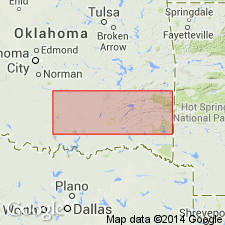
p. 854 (fig. 1), 858, 902-908. Wapanucka formation. Harlton, 1934 (AAPG Bull., V. 18, no. 8) proposed to subdivide Wapanucka into basal, middle, and upper units. It is now proposed to apply names Primrose and Limestone Gap (new) formations to unit heretofore designated as basal Wapanucka. Name Wapanucka is restricted and applied to middle unit (or main lower massive limestone as Taff undoubtedly intended the usage); to upper unit, name Barnett Hill formation is applied. Wapanucka formation has been defined in various ways by different authors. Differences of opinion respecting age arose largely from the fact that Taff did not describe or designate a type locality. Hence it has been customary to accept exposures at town of Wapanucka as type. Section at this locality is not complete and units above Wapanucka have been included at other exposures. Original description by Taff appears to have included chiefly or entirely the lower limestone series, and same limits are observed in this paper. In extreme northwestern Ouachitas, this formation, together with the Barnett Hill, as well as the Primrose, was erroneously designated by Taff, 1902 (U.S. Geol. Survey Geol. Atlas, Folio 79) as Chickachoc chert lentils. Recommended that Chickachoc be abandoned. Thickness of Wapanucka at Taff's possible type locality, 1 mile west of Wapanucka, about 220 feet. At Limestone Gap, near center of E/2 sec. 31, T. 2 N., R. 13 E., thickness is 198 feet. Here Wapanucka overlies Limestone Gap shaie and underlies Barnett Hill formation. Wapanucka is included in Morrow series of Bendian period.
Source: US geologic names lexicon (USGS Bull. 1200, p. 4122-4123).
For more information, please contact Nancy Stamm, Geologic Names Committee Secretary.
Asterisk (*) indicates published by U.S. Geological Survey authors.
"No current usage" (†) implies that a name has been abandoned or has fallen into disuse. Former usage and, if known, replacement name given in parentheses ( ).
Slash (/) indicates name conflicts with nomenclatural guidelines (CSN, 1933; ACSN, 1961, 1970; NACSN, 1983, 2005, 2021). May be explained within brackets ([ ]).