The National Geologic Map Database is migrating to a new infrastructure. We apologize for any service disruptions during this process.
|
|---|


- Usage in publication:
-
- Wall Mountain Tuff*
- Modifications:
-
- Named
- Geochronologic dating
- Dominant lithology:
-
- Tuff
- AAPG geologic province:
-
- Denver basin
Summary:
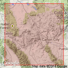
Named for exposures along south end of Wall Mountain in sec 32, T16S, R73W, Black Mountain quad, Fremont Co, CO in the Denver basin. Weathers reddish brown to yellowish buff. Formerly called Agate Creek Tuff (abandoned) and ash flows 1, 2, and 4. Is a multiple-flow (rhyolitic ash-flow tuff) simple-cooling unit. Forms cliff-like outcrops. Is moderate to densely welded and has black vitrophyre locally. Is commonly devitrified. Contains microcrystalline alkali feldspar and silica minerals of vapor-phase origin. Is 90 ft thick at type; is locally as little as 50 ft thick and as much as 500 ft thick. Is the most widely distributed formation of Thirtynine Mile volcanic field occurring at numerous localities between Castle Rock, South Park, northern Wet Mountain Valley, and northwest of Poncha Pass, an area of about 3,500 sq mi. Is the most important stratigraphic unit in the volcanic field because it marks onset of volcanism in earliest Oligocene time, dates a regional post-Laramide erosion surface, and serves as a datum for determining location and magnitude of middle to late Cenozoic block faulting. Source of tuff is unknown. K-Ar ages of 40.0 +/-1.2 and 34.8 +/-1.1 on biotite; 35.4 +/-1.1 and 37.3 +/-1.9 on sanidine and biotite. Assigned as early Oligocene (Chadron) age. Has normal remanent magnetic polarity.
Source: GNU records (USGS DDS-6; Denver GNULEX).
For more information, please contact Nancy Stamm, Geologic Names Committee Secretary.
Asterisk (*) indicates published by U.S. Geological Survey authors.
"No current usage" (†) implies that a name has been abandoned or has fallen into disuse. Former usage and, if known, replacement name given in parentheses ( ).
Slash (/) indicates name conflicts with nomenclatural guidelines (CSN, 1933; ACSN, 1961, 1970; NACSN, 1983, 2005, 2021). May be explained within brackets ([ ]).