The National Geologic Map Database is migrating to a new infrastructure. We apologize for any service disruptions during this process.
|
|---|


- Usage in publication:
-
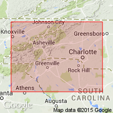
- Walhalla metamorphic suite
- Modifications:
-
- First used
- Dominant lithology:
-
- Gneiss
- Amphibolite
- AAPG geologic province:
-
- Piedmont-Blue Ridge province
Summary:
Walhalla metamorphic suite, here informally named for city in Oconee Co, SC, which it surrounds, is described as a distinctive suite of hornblende-plagioclase gneiss, amphibolite, and interlayered units that are components of the Walhalla nappe detailed by Griffin (1969). Usage of the name Walhalla by Griffin (1974) to denote a small granitoid gneiss in the same vicinity is here abandoned. Structurally overlies the Poor Mountain and Chauga River Formations, but relationship to these units is uncertain.
Source: GNU records (USGS DDS-6; Reston GNULEX).
- Usage in publication:
-
- Walhalla†
- Modifications:
-
- Abandoned
- AAPG geologic province:
-
- Piedmont-Blue Ridge province
Summary:
Author recommends in this report that term Walhalla metamorphic suite of Horton and McConnel (1991) be abandoned immediately because it encompasses parts of several easily separated stratigraphic units and was defined as a petrologic unit based solely on metamorphic grade. Suite includes part of the Poor Mountain Formation and Tallulah Falls Formation in the western Inner Piedmont of northwestern SC.
Source: GNU records (USGS DDS-6; Reston GNULEX).
For more information, please contact Nancy Stamm, Geologic Names Committee Secretary.
Asterisk (*) indicates published by U.S. Geological Survey authors.
"No current usage" (†) implies that a name has been abandoned or has fallen into disuse. Former usage and, if known, replacement name given in parentheses ( ).
Slash (/) indicates name conflicts with nomenclatural guidelines (CSN, 1933; ACSN, 1961, 1970; NACSN, 1983, 2005, 2021). May be explained within brackets ([ ]).