The National Geologic Map Database is migrating to a new infrastructure. We apologize for any service disruptions during this process.
|
|---|


- Usage in publication:
-
- Wagontongue formation
- Modifications:
-
- Named
- Dominant lithology:
-
- Sandstone
- Clay
- AAPG geologic province:
-
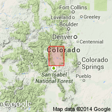
- South Park basin
Summary:
Named for outcrops along Wagontongue Creek, Park Co, CO in South Park basin. Two northward-facing outcrops in secs 29 and 30, T14S, R75W designated the type locality. Section measured in sec 30 described. Occurs only at southern end of Park. Ranges from 110 to 200 ft thick. Composed of poorly consolidated conglomeratic sandstone which contains well-rounded pebbles of andesite?, pebbly, tuffaceous, light gray to brown sandstone, and sandy, brown clay. Some beds of clay are tuffaceous. Considered to be a water-laid deposit. Fossil bones, teeth, and silicified wood identified. Is unconformable on older rocks. Is younger than Antero formation and older than Trump formation. Thought to be late Miocene, Miocene? on Table 7, but may be early Pliocene. Geologic map.
Source: GNU records (USGS DDS-6; Denver GNULEX).
- Usage in publication:
-
- Wagontongue Formation*
- Modifications:
-
- Overview
- AAPG geologic province:
-
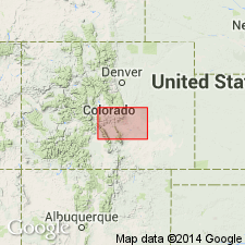
- South Park basin
Summary:
Was named for outcrops along Wagon Tongue Creek, South Park basin, Park Co, CO. The two best outcrops are in secs 31 and 32, T14S, R78W, the type locality. Type locality was mistakenly placed by Stark and others in secs 29 and 30. Consists of fluviatile, cross-stratified, brown, calcareous clayey, and arkosic siltstone, sandstone, and conglomerate deposited as basin fill. Overlies Antero Formation or Gribbles Park Tuff; underlies Quaternary alluvium. Occupies a northwest trending belt 30 mi long and up to 5 mi wide in quad. Vertebrate remains date it as Miocene. Replaces use of Trump Conglomerate, a name abandoned in this report.
Source: GNU records (USGS DDS-6; Denver GNULEX).
- Usage in publication:
-
- Wagontongue Formation*
- Modifications:
-
- Overview
- AAPG geologic province:
-
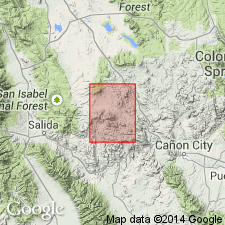
- South Park basin
Summary:
Contains Miocene vertebrate fossils. Mapped in northwest part of quad (T15S, R75W), Park Co, CO in South Park basin.
Source: GNU records (USGS DDS-6; Denver GNULEX).
For more information, please contact Nancy Stamm, Geologic Names Committee Secretary.
Asterisk (*) indicates published by U.S. Geological Survey authors.
"No current usage" (†) implies that a name has been abandoned or has fallen into disuse. Former usage and, if known, replacement name given in parentheses ( ).
Slash (/) indicates name conflicts with nomenclatural guidelines (CSN, 1933; ACSN, 1961, 1970; NACSN, 1983, 2005, 2021). May be explained within brackets ([ ]).