The National Geologic Map Database is migrating to a new infrastructure. We apologize for any service disruptions during this process.
|
|---|


- Usage in publication:
-
- Wachapreague Formation*
- Modifications:
-
- Named
- Geochronologic dating
- Dominant lithology:
-
- Clay
- Silt
- Sand
- AAPG geologic province:
-
- Atlantic Coast basin
Summary:
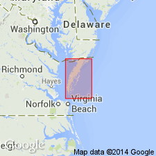
Named Wachapreague Formation for town of Wachapreague, Accomack Co., VA. Type section is a borehole, W-1, 1 mile north-northeast of town. A reference section is designated as exposure of upper gravelly sand unit southeast of Willis Wharf where tidal waters of Parting Creek cut through relict Bell Neck barrier ridge, Accomack Co. The formation is divisible into two lithic units in type section. The lower unit is 20 feet thick and consists of clayey and silty, fine- to very fine-grained gray sand and clayey-silt. The upper unit is 17 feet thick and consists of medium to coarse gravelly, yellowish-gray sand with pebbles of black chert and quartz. Wachapreague unconformably overlies Yorktown Formation; in other places it truncates and (or) overlaps Omar and Nassawadox Formations. The Wachapreague Formation correlates with the upper member of the Sand Bridge Formation of Oaks and Coch (1973) and possibly with the marginal marine beds of the Sinepuxent Formation. Uranium-isotope and amino-acid-racemization dating suggest a Sangamon to early Wisconsinan age (late Pleistocene).
Source: GNU records (USGS DDS-6; Reston GNULEX).

- Usage in publication:
-
- Wachapreague Formation
- Modifications:
-
- Overview
- AAPG geologic province:
-
- Atlantic Coast basin
Summary:
Nomenclature on State map follows Mixon (1985). Wachapreague Formation, east of Chesapeake Bay, is a coarsening upward sequence that includes a lower member of clayey and silty, fine to very fine, gray sand interbedded with clay-silt and an upper member of medium to coarse, gravelly sand. Mollusks, including MESODESMA ARCTATUM and SILIQUA COSTATA, and ostracode assemblages dominated by ELOFSONELLA CONCINNA and MUELLERINA CANADENSIS indicate cooling ocean temperatures during deposition of unit. Pollen assemblage dominated by pine, spruce, birch, and alder suggests cool- to cold-temperate conditions in nearby land areas. Unit is surficial deposit of narrow, arcuate coastal lowland ranging in altitude from sea level, at eastern border with Holocene barrier-lagoon complex, to about 15 ft at toe of ocean-facing scarp forming western boundary. Overlies Nassawadox Formation. Thickness ranges from 0 to 40 ft. Age is late Pleistocene.
Source: GNU records (USGS DDS-6; Reston GNULEX).
For more information, please contact Nancy Stamm, Geologic Names Committee Secretary.
Asterisk (*) indicates published by U.S. Geological Survey authors.
"No current usage" (†) implies that a name has been abandoned or has fallen into disuse. Former usage and, if known, replacement name given in parentheses ( ).
Slash (/) indicates name conflicts with nomenclatural guidelines (CSN, 1933; ACSN, 1961, 1970; NACSN, 1983, 2005, 2021). May be explained within brackets ([ ]).