

- Usage in publication:
-
- Virgelle sandstone*
- Virgelle sandstone member*
- Modifications:
-
- Original reference
- Dominant lithology:
-
- Sandstone
- AAPG geologic province:
-
- Sweetgrass arch
Summary:
Pg. 62-68. Virgelle sandstone of Montana group (northwestern Montana) and Virgelle sandstone member of Eagle sandstone of Montana group (central Montana). Forms bold escarpments and in places hogbacks. Consists of gray to buff coarse-grained massive sandstone, much cross-bedded, with many ferruginous concretions in upper half. In lower half slabby gray sandstone, becoming shaly toward base. Thickness 220 feet on Two Medicine River between its mouth and Family Post Office. Underlies Two Medicine formation in northwestern Montana (Blackfeet Indian Reservation) and overlies Colorado shale. In central Montana, it comprises basal member of Eagle sandstone, and still farther east it represents all of Eagle sandstone that is present. Is well exposed along Missouri River from town of Virgelle, a few miles below Fort Benton, eastward. Age is Late Cretaceous.
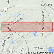
Section of Montana group studied: on Two Medicine River between its mouth and Family Post Office, Blackfeet Indian Reservation, Pondera and Glacier Counties, Montana (Sweetgrass arch) [approx. from NW/4 NW/4 sec. 2, T. 31 N., R. 5 W., Abbott Lake 7.5-min quadrangle, to NW/4 NW/4 sec. 2, T. 31 N., R. 9 W., Piegan 7.5-min quadrangle; Lat. 48 deg. 28 min. 50 sec. N., Long. 112 deg. 13 min. 45 sec. W. to Lat. 48 deg. 28 min. 55 sec. N., Long. 112 deg. 44 min. 40 sec. W. (from USGS GNIS database and ACME Mapper 2.0, accessed February 22, 2009)].
[GNC remark (ca. 1938, US geologic names lexicon, USGS Bull. 896, p. 2253): In Yellowstone-Bighorn Counties region the 350+/- feet of transition beds underlying Virgelle sandstone member of Eagle sandstone and containing a fauna of predominantly Montana types are now known as Telegraph Creek formation. In that area the Telegraph Creek formation separates Virgelle sandstone member of Eagle from deposits of unquestioned Colorado age, carrying Niobrara fossils and designated Niobrara shale.]
Source: US geologic names lexicon (USGS Bull. 896, p. 2253).
- Usage in publication:
-
- Virgelle Sandstone
- Modifications:
-
- Overview
- AAPG geologic province:
-
- Montana folded belt
Summary:
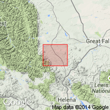
Is mapped with Telegraph Creek Formation in Lewis and Clark Co, MT in Montana folded belt province. In report area the Telegraph Creek and Virgelle crop out along ridges running parallel with valleys of Flat and Auchard Creeks. Thickness ranges from 147 to 180 ft. Lower part of unit is grayish yellow (5Y 8/4), medium to very thick bedded, slabby to massive sandstone as much as 7 ft thick interbedded with shale and shaly mudstone. Upper part is yellowish gray (5Y 7/2), very thick bedded (15-40 ft thick), massive, cliff-forming sandstone locally interbedded with thin beds of lignitic shale. Major detrital grains of upper massive beds include quartz, plagioclase, biotite, and partly devitrified grains of vitrophyric, volcanic rock. Predominant cement is authigenic calcite; where absent sandstone is friable. Is generally nonfossiliferous, though a few pelecypods were found in upper 3 ft. Telegraph Creek-Virgelle contact placed where thin- to medium-bedded sandstone first grades upward to very thick bedded, massive sandstone. Virgelle-Two Medicine contact placed at top of the lowest magnetite-rich bed that was overlain by a coal or lignitic shale. Age is Late Cretaceous.
Source: GNU records (USGS DDS-6; Denver GNULEX).
- Usage in publication:
-
- Virgelle Sandstone*
- Modifications:
-
- Mapped 1:24k
- Dominant lithology:
-
- Sandstone
- AAPG geologic province:
-
- Montana folded belt
Summary:
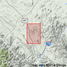
Is mapped in eastern Lewis and Clark Co, MT in the Montana folded belt province. Overlies Telegraph Creek Formation; underlies Two Medicine Formation. Is light-greenish-gray, light-gray, and white; poorly to moderately well indurated, fine to medium grained, massive but locally thinly bedded and cross-bedded; large dark-brown and gray calcareous sandstone concretions common; zone of dark-reddish-brown magnetite-rich sand, as much as 6 ft thick, at top; invertebrate fossils scarce; mainly MACTRA ARENARIA Meek; 140-160 ft thick. Age is Late Cretaceous.
Source: GNU records (USGS DDS-6; Denver GNULEX).
For more information, please contact Nancy Stamm, Geologic Names Committee Secretary.
Asterisk (*) indicates published by U.S. Geological Survey authors.
"No current usage" (†) implies that a name has been abandoned or has fallen into disuse. Former usage and, if known, replacement name given in parentheses ( ).
Slash (/) indicates name conflicts with nomenclatural guidelines (CSN, 1933; ACSN, 1961, 1970; NACSN, 1983, 2005, 2021). May be explained within brackets ([ ]).