

- Usage in publication:
-
- Vicksburg group
- Modifications:
-
- Named
- AAPG geologic province:
-
- Mid-Gulf Coast basin
Summary:
Author divides the Eocene into "Upper or Newer Eocene" and "Lower or Older Eocene," and states that Vicksburg group belongs to former and Claiborne sands to latter. Neither Vicksburg group nor Claiborne sands is described. The former he correlated with the "white limestone of St. Stephens and uppermost stratum at Claiborne, AL."
Source: GNU records (USGS DDS-6; Reston GNULEX).
- Usage in publication:
-
- Vicksburg formation
- Modifications:
-
- Revised
- AAPG geologic province:
-
- Mid-Gulf Coast basin
Summary:
Rank reduced to formation. Comprises Mint Spring facies, Glendon and Byram members. Disconformably overlies Jackson formation; disconformably underlies Citronelle formation.
Source: GNU records (USGS DDS-6; Reston GNULEX).
- Usage in publication:
-
- Vicksburg group*
- Modifications:
-
- Revised
- AAPG geologic province:
-
- Mid-Gulf Coast basin
Summary:
Vicksburg group is restricted to middle part of the Oligocene, namely Marianna limestone (with Mint Spring marl member) and Byram formation (with Bucatunna clay and Glendon limestone members). Excluded from group are the three youngest Oligocene formations --Chickasawhay limestone, Suwannee limestone, and Flint River formation --and basal Oligocene formations --Forest Hill sand, and Red Bluff clay. Thus, the Vicksburg includes only beds for which name was intended, the fossiliferous Oligocene of Warren Co., MS. This restriction is not a new idea. Various geologists have suggested that the top, or bottom, or both, of the Oligocene be removed from the Vicksburg, some have suggested that the upper part is Miocene, and others that the lower part is Eocene.
Source: GNU records (USGS DDS-6; Reston GNULEX).
- Usage in publication:
-
- Vicksburg Formation*, Group*
- Modifications:
-
- Age modified
- AAPG geologic province:
-
- Mid-Gulf Coast basin
Summary:
Age of Vicksburg Formation and Group revised from middle Oligocene to early Oligocene based on nannofossils.
Source: GNU records (USGS DDS-6; Reston GNULEX).
- Usage in publication:
-
- Vicksburg Group*
- Modifications:
-
- Revised
- AAPG geologic province:
-
- Mid-Gulf Coast basin
Summary:
Forest Hill Sand and Red Bluff Clay (partially equivalent) reassigned to lower part of Vicksburg Group as used by Deboo (1965: AL G. S. Bull. 80, 84 p.). Forest Hill overlies Red Bluff Clay or Yazoo Clay of Jackson Group and underlies Marianna Limestone of Vicksburg. Red Bluff overlies Yazoo Clay or Ocala Limestone of Jackson Group and underlies Forest Hill Sand or Marianna Limestone.
Source: GNU records (USGS DDS-6; Reston GNULEX).
- Usage in publication:
-
- Vicksburg Group*
- Modifications:
-
- Revised
- AAPG geologic province:
-
- Mid-Gulf Coast basin
Summary:
Vicksburg Group divided into (ascending): Mint Spring Formation (formerly marl member of Marianna Limestone), Marianna Formation (formerly Marianna Limestone), Glendon Formation (formerly lower limestone member of Byram Formation), Byram Formation, and Bucatunna Formation (formerly upper clay member of Byram). Forest Hill Sand and Red Bluff Clay no longer assigned to lower part of Vicksburg Group but remain of Vicksburgian Age. Vicksburg overlies Forest Hill, Red Bluff, and Bumpnose Formations and underlies Chickasawhay Formation.
Source: GNU records (USGS DDS-6; Reston GNULEX).
- Usage in publication:
-
- Vicksburg Group
- Modifications:
-
- Overview
- AAPG geologic province:
-
- Mid-Gulf Coast basin
Summary:
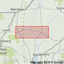
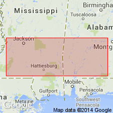
Lower Oligocene (Rupelian) Vicksburg Group includes, in ascending order, the Bumpnose Limestone, the Red Bluff Clay, the Forest Hill Sand, the Mint Spring Marl Member of the Marianna Limestone (Mint Spring Formation in MS), the Marianna Limestone, the Glendon Limestone Member of the Byram Formation (Glendon Limestone in MS), the informal "Byram marl" member of the Byram Formation (Byram Formation in MS), and the Bucatunna Clay Member of the Byram Formation (Bucatunna Clay in MS). Current Geological Survey of Alabama usage includes the Forest Hill Sand, Red Bluff Clay, and Bumpnose Limestone in the Vicksburg and excludes the Chickasawhay Limestone. This usage is followed in the present report.
Source: GNU records (USGS DDS-6; Reston GNULEX).
- Usage in publication:
-
- Vicksburg Group
- Modifications:
-
- Overview
- Areal extent
- AAPG geologic province:
-
- South Georgia sedimentary province
Summary:
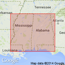
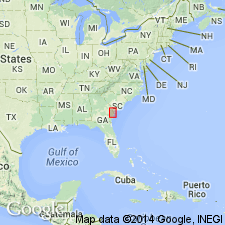
In conflict with the Code, it is not the similar lithologies or common lithologic features that unite the formations of the Vicksburg Group, but rather the fact that they contain a common fauna. In MS and AL, where the formations of the original group are found, the Vicksburg is still applied as a lithostratigraphic unit. In GA, the Group consists only of outliers of Marianna Limestone and Glendon Limestone, and in Peninsular FL none of the formations of the Vicksburg are present but stratigraphically equivalent formations are. There the term Vicksburgian Stage is more appropriate. In GA, because the Marianna and Glendon Limestones are present, the term Vicksburg Group is retained. The Vicksburg is restricted to the eastern Gulf Coastal Plain west and north of the Gulf Trough. In GA, the Vicksburg is restricted in known occurrence to the vicinity of Hawkinsville in Pulaski Co. Vicksburg limestones may occur along a southwest-northeast band from the vicinity of Hawkinsville southwestward for some distance. At one time the occurrence of the Vicksburg may have been continuous across the Dougherty Plain from Jackson Co., FL, northeastward to Pulaski Co. Group is assigned to the Rupelian Stage.
Source: GNU records (USGS DDS-6; Reston GNULEX).
For more information, please contact Nancy Stamm, Geologic Names Committee Secretary.
Asterisk (*) indicates published by U.S. Geological Survey authors.
"No current usage" (†) implies that a name has been abandoned or has fallen into disuse. Former usage and, if known, replacement name given in parentheses ( ).
Slash (/) indicates name conflicts with nomenclatural guidelines (CSN, 1933; ACSN, 1961, 1970; NACSN, 1983, 2005, 2021). May be explained within brackets ([ ]).