

- Usage in publication:
-
- Ventura formation*
- Modifications:
-
- Named
- Dominant lithology:
-
- Sandstone
- Shale
- Conglomerate
- AAPG geologic province:
-
- Okanogan province
- Cascades province
Summary:
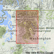
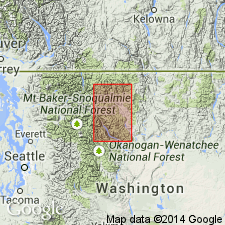
Provisionally named for abandoned mining camp [presumably on west side of Methow Valley opposite Goat Wall] whence it extended locally on both sides of the valley southeastward 15 mi to within 5 mi of Winthrop, Okanogan Co, WA. [No type given.] Is thick-bedded sandstone, shale, and coarse conglomerate, distinctively red-brown in color. Assigned "Juratrias(?)" because of its "Triassic red color" and its association with, but structural and lithological contrasts to Similkameen formation (new) and Winthrop sandstone (new) both of Cretaceous age.
Source: GNU records (USGS DDS-6; Menlo GNULEX).
- Usage in publication:
-
- Ventura Member
- Modifications:
-
- Revised
- Age modified
- Overview
- AAPG geologic province:
-
- Okanogan province
- Cascades province
Summary:
[Name Ventura Formation first used by Russell (1900) for exposures in mountains bordering Methow Valley.] Rank lowered to basal named member of Midnight Peak Formation (new). Type section designated as exposures on Lucky Jim Bluff 9 mi northwest of Winthrop on west side of Methow Valley in parts of secs.8,9,16-17 T35N R20E, Mazama 15' quad, Okanogan Co, WA. Measured section of 2034 ft is mainly red beds of sandstone and shale. Age is Late Cretaceous based on gradational relationship with underlying Winthrop Sandstone (of Late Cretaceous age).
Source: GNU records (USGS DDS-6; Menlo GNULEX).
For more information, please contact Nancy Stamm, Geologic Names Committee Secretary.
Asterisk (*) indicates published by U.S. Geological Survey authors.
"No current usage" (†) implies that a name has been abandoned or has fallen into disuse. Former usage and, if known, replacement name given in parentheses ( ).
Slash (/) indicates name conflicts with nomenclatural guidelines (CSN, 1933; ACSN, 1961, 1970; NACSN, 1983, 2005, 2021). May be explained within brackets ([ ]).