The National Geologic Map Database is migrating to a new infrastructure. We apologize for any service disruptions during this process.
|
|---|


- Usage in publication:
-
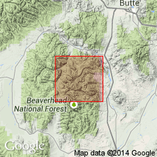
- Uphill Creek Granodiorite*
- Modifications:
-
- Named
- Dominant lithology:
-
- Granodiorite
- AAPG geologic province:
-
- Montana folded belt
Summary:
Named for exposures in drainage area of Uphill Creek in south-central part of map area, Beaverhead Co, MT in the Montana folded belt province. These exposures are called the type locality. Is composed of medium to coarse, gray, massive granodiorite. Constitutes largest pluton (of five) of Pioneer batholith. Has biotite K-Ar age of 72.6 +/-2.8 m.y. and hornblende K-Ar age of 69.5 +/-2.0 m.y., or Late Cretaceous age.
Source: GNU records (USGS DDS-6; Denver GNULEX).
For more information, please contact Nancy Stamm, Geologic Names Committee Secretary.
Asterisk (*) indicates published by U.S. Geological Survey authors.
"No current usage" (†) implies that a name has been abandoned or has fallen into disuse. Former usage and, if known, replacement name given in parentheses ( ).
Slash (/) indicates name conflicts with nomenclatural guidelines (CSN, 1933; ACSN, 1961, 1970; NACSN, 1983, 2005, 2021). May be explained within brackets ([ ]).