

- Usage in publication:
-
- Unga conglomerate
- Modifications:
-
- Named
- Dominant lithology:
-
- Conglomerate
- AAPG geologic province:
-
- Alaska Peninsula province
- Alaska Southwestern region
Summary:
Consists of brown conglomerates with SEQUOIA, occurring on Unga Island, AK. Conformably overlies coal-bearing Miocene beds. Forms upper beds of Kenai group of early Miocene or latest Eocene age. [Kenai formation is now classified as Eocene and is restricted to its type region, Kenai Peninsula (Dall, 1898)]
Source: GNU records (USGS DDS-6; Menlo GNULEX).
- Usage in publication:
-
- Unga formation*
- Modifications:
-
- Adopted
- Redescribed
- Dominant lithology:
-
- Tuff
- Conglomerate
- Shale
- AAPG geologic province:
-
- Alaska Peninsula province
- Alaska Southwestern region
Summary:
Unga conglomerate of Dall and Harris (1892) is here designated Unga formation because unit does not contain much conglomerate. Measured section (Dall, 1872) shows unit contains tuff, conglomerate, sandstone, and shale. Age is Miocene based on flora (collected by Hollick) and fauna (collected by Dall).
Source: GNU records (USGS DDS-6; Menlo GNULEX).
- Usage in publication:
-
- Unga conglomerate*
- Modifications:
-
- Areal extent
- AAPG geologic province:
-
- Alaska Peninsula province
- Alaska Southwestern region
Summary:
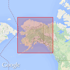
Referred to type area as Unga Island, southwest AK. Section about 200 ft thick was measured by Dall in 1872 on Unga Island where series consisted largely of conglomerates with some shales and sandstones containing in places abundant marine fossils. Also recognized at other places in same general region as on shores of Balboa and Herendeen Bays and Port Moller. At Port Moller, beds attain thickness of at least 1000 ft. In type area, Unga conglomerate appears to rest conformably on highest recognized Eocene stratum but this is not believed to be normal relation, as beds usually show much less deformation than the Eocene deposits. Unit is Miocene age based on invertebrate fossils collected from these localities.
Source: GNU records (USGS DDS-6; Menlo GNULEX).
- Usage in publication:
-
- Unga Conglomerate Member
- Modifications:
-
- Revised
- Age modified
- AAPG geologic province:
-
- Alaska Peninsula province
- Alaska Southwestern region
Summary:
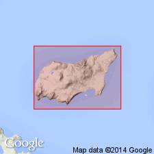
Unga Conglomerate (Dall and Harris, 1892) is here considered Unga Conglomerate Member in basal part of Bear Lake Formation. This member distinguished by its inclusion of MYTILUS MIDDENDORFFI and constituting all older rocks in Bear Lake Formation. On Unga Island unit contains plants which are dated by J.A. Wolfe (USGS) as late Oligocene(?) to middle Miocene. Plants are from collection by Dall and Harris (1892). Type section at Zachary Bay is 800 feet thick.
Source: GNU records (USGS DDS-6; Menlo GNULEX).
- Usage in publication:
-
- Unga Conglomerate Member*
- Modifications:
-
- Age modified
- Biostratigraphic dating
- Revised
- AAPG geologic province:
-
- Alaska Peninsula province
- Alaska Southwestern region
Summary:
[Recognized as Unga Conglomerate Member of Burk's (1965) Bear Lake Formation.] Age is middle(?) Miocene on basis of Marine megafossil, MYTILUS MIDDENDORFFI (collected from upper part of Unga Conglomerate Member and upward into middle part of Bear Lake Formation).
Source: GNU records (USGS DDS-6; Menlo GNULEX).
- Usage in publication:
-
- Unga Conglomerate Member*
- Modifications:
-
- Age modified
- Biostratigraphic dating
- AAPG geologic province:
-
- Alaska Peninsula province
- Alaska Southwestern region
Summary:
Age of Unga Conglomerate Member is early and/or middle Miocene on basis of included fossil, TYRANNOBERINGIUS REX, [following intent of Allison (1978)]
Source: GNU records (USGS DDS-6; Menlo GNULEX).
- Usage in publication:
-
- Unga Conglomerate Member*
- Modifications:
-
- Age modified
- AAPG geologic province:
-
- Alaska Peninsula province
- Alaska Southwestern region
Summary:
Age of Unga Conglomerate Member on Cape Aliaksin is middle Miocene based on correlation with molluscan species on Ukolnoi Island, age refinement of molluscan stages by Addicott (1981), and K-Ar age of 10.4 +/-0.49 Ma for overlying andesite flow.
Source: GNU records (USGS DDS-6; Menlo GNULEX).
- Usage in publication:
-
- Unga Formation*
- Modifications:
-
- Revised
- Biostratigraphic dating
- AAPG geologic province:
-
- Alaska Peninsula province
- Alaska Southwestern region
Summary:
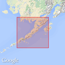
Unit everywhere revised to Unga Formation as it is mappable unit lithologically distinct from Bear Lake Formation. Type section of Burk (1965) is redefined to include more units; measured section is along west shore of Zachary Bay from White Bluff northwestward along coast to Unga Spit, Port Moller B-2 and B-3 quadrangles (scale 1:63,360). Age is stated as late Oligocene to middle Miocene based on megafauna and pollen fossils.
Source: Modified from GNU records (USGS DDS-6; Menlo GNULEX).
For more information, please contact Nancy Stamm, Geologic Names Committee Secretary.
Asterisk (*) indicates published by U.S. Geological Survey authors.
"No current usage" (†) implies that a name has been abandoned or has fallen into disuse. Former usage and, if known, replacement name given in parentheses ( ).
Slash (/) indicates name conflicts with nomenclatural guidelines (CSN, 1933; ACSN, 1961, 1970; NACSN, 1983, 2005, 2021). May be explained within brackets ([ ]).