

- Usage in publication:
-
- Uinta
- Modifications:
-
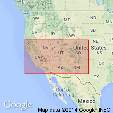
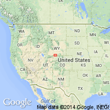
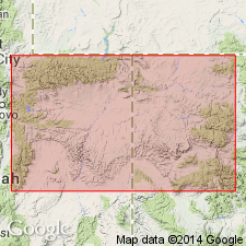
- Areal extent
- AAPG geologic province:
-
- Green River basin
- Uinta basin
Summary:
Map 2 (Green River Basin ) [from advance copy distributed in 1875.] Showed following superposition of strata in northeastern Utah (descending): Wyoming conglomerate (Pliocene), Uinta (Eocene), Bridger (Eocene), Green River (Eocene), and Vermilion Creek (Eocene). Uinta as here used apparently included Browns Park formation.
Source: US geologic names lexicon (USGS Bull. 896, p. 2209-2210).
- Usage in publication:
-
- Uinta group*
- Modifications:
-
- Revised
- AAPG geologic province:
-
- Green River basin
- Uinta basin
Summary:
Pg. 405, 531-544. Uinta group (latest Eocene). Lower members chiefly rough, gritty conglomerate, passing up into finer-grained sandstones and at certain points developing creamy calcareous beds. Is a shallow-water deposit, in all probability the sediment of a very restricted post-Bridger lake, wholly south of Uinta Range, and the last member of that remarkable series of Eocene lakes whose great deposits are piled unconformably over one another in the region. This group alone should Uinta be applied. As provisionally used on the 40th Parallel Atlas Uinta group was a term stretched for convenience to cover all Tertiaries south of Uinta Range; of whose true subdivisions we were ignorant. Thickness 500(?) feet; 400 feet only exposed. Marsh and Emmons by accident gave same name to the group. Vertebrates found in the continuation of these beds in White River Valley belong to a period higher than Bridger series. They even contain some forms closely approaching lowest Miocene types. Believed to be unconformable with all earlier Eocene groups, including Bridger. [Apparently included Browns Park formation.]
Source: US geologic names lexicon (USGS Bull. 896, p. 2209-2210).
- Usage in publication:
-
- Uinta formation*
- Modifications:
-
- Overview
- AAPG geologic province:
-
- Uinta basin
Summary:
Recognized as equivalent to the saline facies of the Green River formation of the western sections. Identified on cross section from western Duchesne Co, UT to the eastern Duchesne Co border, UT in the Uinta basin. This sequence overlies the Green River and was formerly called Bridger formation with horizons A and B. Divisible into a saline and a sandstone and limestone facies in western Duchesne Co. The saline facies intertongues eastward with the basal sandstone and banded facies in eastern Duchesne Co. Entire formation has a maximum thickness of 3,650-4,050 ft thick. Formation is a thick fluviatile deposit with minor amount of lacustrine beds. The lower 1,650 ft are lacustrine, playa, and mud-flat origin.
Source: GNU records (USGS DDS-6; Denver GNULEX).
- Usage in publication:
-
- Uinta Formation*
- Modifications:
-
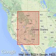
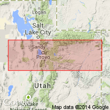
- Areal extent
- AAPG geologic province:
-
- Green River basin
Summary:
Is a unit of Eocene age that is replaced in Washakie basin within the Greater Green River basin by the Washakie Formation of Eocene age.
Source: GNU records (USGS DDS-6; Denver GNULEX).
- Usage in publication:
-
- Uinta Formation*
- Modifications:
-
- Areal extent
- AAPG geologic province:
-
- Piceance basin
- Uinta basin
Summary:
Replaces use of name Bridger Formation in Uinta basin; replaces use of Evacuation Creek Member of Green River Formation and of Bridger Formation in Piceance basin. Is of Eocene age.
Source: GNU records (USGS DDS-6; Denver GNULEX).
- Usage in publication:
-
- Uinta Formation*
- Modifications:
-
- Revised
- AAPG geologic province:
-
- Piceance basin
Summary:
Four of several marlstones in the Eocene Green River Formation that intertongue with Uinta Formation and merge with Parachute Creek Member of Green River Formation in the northern Piceance Creek basin (of the larger Piceance basin), named. These are, in ascending stratigraphic order: Yellow Creek, Dry Fork, Thirteenmile Creek, and Black Sulphur Tongues. They are of Eocene age.
Source: GNU records (USGS DDS-6; Denver GNULEX).
- Usage in publication:
-
- Uinta Formation*
- Modifications:
-
- Revised
- AAPG geologic province:
-
- Piceance basin
Summary:
A marlstone tongue of the Green River Formation named Coughs Creek Tongue separates the Uinta Formation into two parts near Cow Creek, Rio Blanco Co, CO in the Piceance basin. Coughs Creek is a conspicuous marker. It is separated from the Parachute Creek Member of the Green River by about 400 ft of Uinta. It is overlain by about 600 ft of Uinta. Uinta at the base of the Coughs Creek is a tan siltstone that grades into very fine grained sandstone and has abundant carbonaceous trash. The Uinta above the top of the Coughs Creek is a tan, very fine grained sandstone with abundant carbonaceous trash. Eocene age.
Source: GNU records (USGS DDS-6; Denver GNULEX).
For more information, please contact Nancy Stamm, Geologic Names Committee Secretary.
Asterisk (*) indicates published by U.S. Geological Survey authors.
"No current usage" (†) implies that a name has been abandoned or has fallen into disuse. Former usage and, if known, replacement name given in parentheses ( ).
Slash (/) indicates name conflicts with nomenclatural guidelines (CSN, 1933; ACSN, 1961, 1970; NACSN, 1983, 2005, 2021). May be explained within brackets ([ ]).